
by Michael R. Allen
Versions of this article were published in Common Ground, Spring 2003 and the already-missed Creative St. Louis, March 2010.
Along the southwest edge of the city of St. Louis, Missouri runs a six-mile curve of what appears to be a river with paved banks. This river is usually dry and rarely filled to even half its capacity. Covered in rip-rap and white stones along this six miles, the banks form a visual boundary of the city limits — although the actual city line is several hundred yards west. Still, the moat-like river creates an effective border between the middle-class parts of the county and city that occupy either side of it. Yet this river actually unites them, because it carries away all of their wasted water and, deep below its channel, their sewage. The river is the River Des Peres, a harnessed channel that was transformed from a natural waterway into a massive civil engineering project in the early twentieth century.
Of course, the River Des Peres is not simply a deep gorge that carries away waste water from the city and its inner suburbs. In fact, it now lies almost completely underground and is not visible at all. In a 1988 booklet published by the Metropolitan Sewer District (MSD), the quasi-governmental agency that has controlled the river since 1956, an anonymous author writes that “the rocky banks of the River Des Peres form a landmark which nearly every St. Louisan recognizes, but few understand.” Few Saint Louisans realize that its 18 miles extend along over half of the city’s western edge, covering a drainage area of 115 square miles and serving a population of over 535,000 people. It enters the city at Skinker Boulevard and Vernon Avenue at the University City limits and then winds its way through Forest Park and into the familiar open section that drains into the Mississippi River. Along the way, it carries both storm water and sewage in separate pipes with connections to most major city and inner-suburban trunk sewers. It is the backbone of the St. Louis sewer system.
Very few residents recognize that the River Des Peres became the backbone of the St. Louis sewer system by having its natural state completely rebuilt so that none of its original features remain. No living person likely remembers the days when all of it was an open and wild, albeit polluted, waterway that St. Louisans happened to dump sewage into. And few accounts describe its earlier incarnation as a pure waterway far from the French settlements on the Mississippi River. In those days, the idea of the River Des Peres becoming one of the largest regional civil engineering projects in the Midwest would have seemed strange. Yet St. Louisans slowly converted the small river into their largest sewer over the course of more than a hundred years, so most of the changes were hardly noticed until the river was already irreversibly controlled by engineers looking to drain unwanted materials from the young city of St. Louis.
Today, the River Des Peres is a complicated and vital part of the second nature that keeps the Saint Louis urban area healthy for its human population. The river itself has, for the most part, been successfully controlled. If the Metropolitan Sewer District replaced the River Des Peres sewer with another one and decided to let the river return, most likely the channel would still only occasionally fill with rainwater. The channel has no source, because the natural ponds and wetlands in St. Louis County that fed it have also been turned into parts of the area’s sewer system. Plans to restore its above-ground flow through Forest Park are complete, but they rely on mechanical pumps to regulate flow and maintain a high water level. Notably, this “restored” section is not connected to the channels under the park.
Yet the River Des Peres occasionally reminds St. Louisans that while it is usually under their control, it can still occasionally overpower that control. In 1973 and 1993 it overflowed its banks and destroyed homes in south city. It has also begun to gradually shed the appearance of an engineering project. Since the river’s open banks were first paved, a variety of grasses, flowers, and trees have taken root in the cracked pavement. Now, throughout the summer months, those concrete banks are partly green. From about March to November, visitors to the open channel can find ducks, geese, turtles, frogs, toads, and snakes living in its channel and on its banks, while the enclosed channel attracts rats and snakes. Both above and below ground, then, the River Des Peres remains very much an ecological being.
Two episodes are particularly useful in examining St. Louis’s attitude toward the River Des Peres: the massive civil engineering efforts of the 1920s and 1930s that finalized human control and the failed 1972 initiative to turn parts of it into a recreational area. Both show that the city sees a symbolic value in controlling this once-wild river at its western edge and that even efforts to re-naturalize it occur within the realm of civil — and not ecological — engineering. St. Louis continues to overlook the fact that the River Des Peres is not simply a public work but also a part of nature.
The City Encroaches
The river was named for two French Jesuit priests, Father Gabriel Marest and Francois Pinet, who, in about the year 1700, founded a mission near its mouth at the Mississippi River and downriver from the village of Cahokia, Illinois. This was 64 years before St. Louis was founded, and it appeared to be a tranquil setting for religious work. The priests sought to minister to the Kaskaskia and Tamaroa Indians and the villagers from Cahokia, although they eventually abandoned the mission because the “low-lying, swampy lands” nearby supported malaria-carrying mosquitoes. In those days, the river carried a constant flow of water.
Within two hundred years, though, the burgeoning city of St. Louis was looking to its west for expansion. As the city limits moved further west, residents set their sights on the river as a possible way to drain sewage and storm water from their expansion projects. According to the Metropolitan Sewer District booklet, the River Des Peres was “recognized as a valuable resource as far back as 1876.” Not surprisingly, that was the year that the current city limits were fixed and the River Des Peres fell almost entirely (save for a small northern section) under city control.
As developers sent sewage into the River Des Peres, city planners realized that a more permanent way of using the river as a sewer was needed. The central city was already overusing the old Mill Creek as its primary sewer, but planners hesitated to turn all of the River Des Peres into a giant open sewer. They developed a plan to drain the expanded city, and “the objectives of this plan were to collect sewage flows in the upper River Des Peres watershed and carry them eastward to the Mississippi River via the Mill Creek sanitary sewer line, thereby preventing the discharge of sewage into the River Des Peres.” Since St. Louis had a sewer system that combined storm water runoff and sewage in the same channels, use of the River Des Peres as a sewer would mean its complete and permanent pollution — something that was unpalatable in the late nineteenth century when most of the city was already facing problems of odor and hygiene.

Yet developers in the western part of the city did not wait for the city to implement its costly plans and instead continued to use the River Des Peres to drain their new, affluent subdivisions. As historian Katherine Corbett writes, “in 1887, [Sewer Commissioner] Robert McMath realized that until he extended the main public sewers into the fashionable West End, developers would continue to pipe sewage into the natural water courses, particularly the River Des Peres.” The plan to divert this water into the Mill Creek sewer was urgently needed, but it never came to fruition. The Mill Creek itself was a natural waterway that city engineers harnessed earlier in the century, and its aging entry pipes and channel walls needed improvements before it could receive new sewage. Thus “by 1894, the River Des Peres was ‘nothing less than a monster open sewer, poisoning the air with the most dangerous corruption and menace to health known, the corruption of sewage.'” The city did very little to stop the flow of sewage into the River Des Peres, most likely because it did not want to halt the rapid development on the west side of the city. If the River Des Peres had been preserved as a natural river, subdivision of the western city would have been stalled until at least the 1920s, and the city would have lost that population as well as its national status as a growing metropolis. Besides, most of the people moving westward were wealthy city residents escaping the unpleasant central city. Among them were many of the people who would ultimately determine the River Des Peres’ fate.
Before the turn of the century, the city attempted to construct a new sewer to carry sewage away from the River Des Peres, building a line that carried water from the West End to downtown. Called the Pine Street Sewer, this structure was woefully inadequate. As Corbett writes:
During the twelve years it had taken to build the Pine Street Sewer, more and more raw sewage drained into the polluted River Des Peres. Once completed, the new sewer frequently overloaded the Mill Creek Sewer, again sending sewage into the River Des Peres.
With the 1904 World’s Fair being planned and continued western development anticipated, the city had to implement some plan to keep the River Des Peres from becoming an embarrassing health hazard. The ecological consequences of overloading the river with sewage had already been accepted de facto. Lacking a permanent solution by 1904, the city began enclosing the river’s curving Forest Park section in “a large wooden box.” This kept the sights and smells of the river away from visitors and the river permanently underground through the park. Although this enclosure might seem a hasty and temporary solution, it represents the first major step toward the current human control over the river.
By 1910, St. Louis was ready to go further: Mayor Frederick Kreismann announced that the city would build a permanent enclosure of the channel from the city limits down to Manchester Avenue. This $4 million plan was too costly, and a period of inaction followed. A $1 million plan to separate sewage from storm water in the section of the river from Lansdowne Avenue to the Mississippi River was completed by 1913, though. This section of the open channel was the first one built that remains in place today.
In August 1915, the river dramatically asserted itself after a chance tropical gulf storm hit the city, overflowing the river’s banks throughout St. Louis. The impact was felt widely, as 400 local and 15 long distance telephone lines went dead, three Forest Park bridges were swept away, houses in suburban Maplewood were flooded to the second floor, and sewers backed up everywhere. Eleven people died, about 1,025 homes were destroyed, and the city experienced an additional $1 million worth of property damage. Kreismann’s plan would have prevented much of this damage, as his successor realized: “Mayor Henry Kiel stated that the only way to prevent similar disasters was to expend about $10 million to implement the plans which had been drafted in 1910.” Of course, no plan other than completely filling in the river’s channel would offer complete security against large-scale floods. Even after engineers completed their work on the river, it twice overflowed its banks.
From River to Sewer, Completely
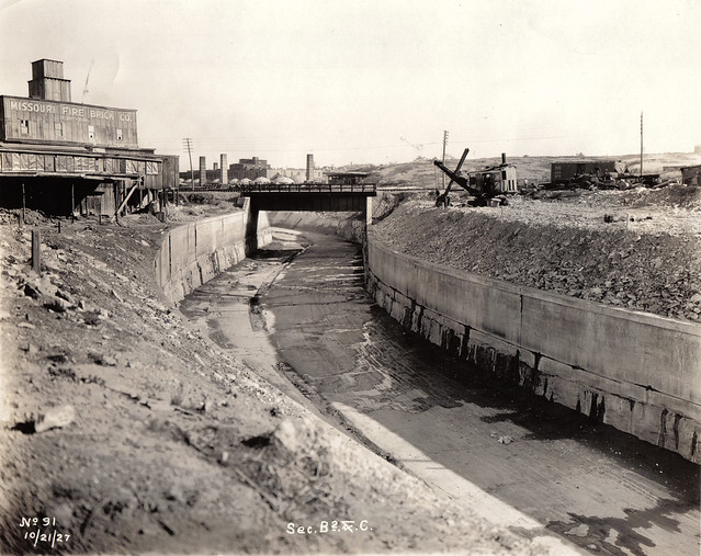
After the flood, W.W. Horner, chief engineer for the Board of Public Service, prepared a proposal to extensively engineer the section of the River Des Peres that lay within city limits. Using rainfall and runoff data, Horner prepared a new route for the river that he submitted to the city on December 16, 1916. Horner’s plan was approved and gave the river the shape that it has today. Realigning and covering eighteen miles of former river would cost the city $11 million, which had to be financed through a bond issue. The city placed 21 of its proposed public works projects, including Horner’s plans, to a vote on February 9, 1923. The River Des Peres project passed with a 78 percent majority even though it was the second-most expensive project on the ballot.

Horner’s plan apportioned the river into sections, which were lettered “A” through “J.” This lettering more than any other aspect of the plan shows how it aimed to make the River Des Peres subservient to human needs once and for all. Rather than seeing it as an ecosystem that could be respected to some extent even as it was managed with an eye towards the city’s needs, Horner saw the river as a series of projects that needed to be completed. Work began on the three-mile open channel of section “A” in 1924 and ended with the completion of the six-mile section “J” in 1933. During this time, the River Des Peres was drained and its course changed. Sewage pipes were separated from the storm water channel along the entire length. The storm water channel ran for about nine miles underground in double-arched tunnels measuring 58 feet wide before flowing into a nine-mile open channel that started around Macklind Avenue.
As the project was nearing completion, Horner spoke to City Beautiful magazine about his work — explicitly articulating many of St. Louis’s assumptions about the symbolism of the project. The resulting article, from November 1929, and a subsequent update in December 1930, both have revealing titles: “St. Louis Puts the River Des Peres Into its Place” and “Transforming the River Des Peres into the World’s Most Gigantic Sewer.” These titles express the underlying symbolism that motivated much of the city’s interest in capturing the river. There is little effort in the titles or the content of the two articles to conceal the notion that the River Des Peres project was a great conquest of wild nature. A feature that followed the 1929 article on another expensive sewer line — this one underground — leading to the new southwestern neighborhood of St. Louis Hills also underscores this fact. Obviously, St. Louis could have built needed storm water and sewer lines without disturbing the River Des Peres, although that would certainly have been more expensive and less impressive.
Indeed, Horner boasts of the visible civilizing of the River Des Peres. In the 1929 article, he is quoted as having said: “Compared to the Panama Canal, the project is a little one, but as an undertaking, even for progressive St. Louis, it has required major operation. As a sewer, it is probably the biggest and the best in the world . . . .” Clearly, the River Des Peres project serves as a metaphor for the city’s completion of its westward growth. The comparison ties the river to an American tradition of expansion of settlement and human commerce that the Panama Canal epitomized in the early twentieth century. Similarly, the comparison to the commercial-military Panama Canal project demonstrates that Horner found the social utility of the new River Des Peres more important than any ecological changes to the St. Louis watershed that the project might engender. Horner praises the way in which the River Des Peres now serves new development and doesn’t even trifle with any supposed beauty; use is all that matters in his evaluation. The author of the 1930 article echoes Horner’s concerns, stating that “I do not think any of us appreciated when we were figuring out the required size of the channels and drawing pictures of them in the plans just how truly tremendous the floodways would appear.” Here, the visible open channel attracts attention — probably because it resembles the original river enough to suggest its being conquered, unlike the unseen and artificial underground section.
Next: Sewer to River?
Later efforts to prevent mudslides involved the paving of most of the open channel’s banks. Between late 1933 and late 1940, the city and then the federal Works Progress Administration hired unemployed workers to pave the muddy banks, at one time renting eight different quarries. As a result, the lower channel took on a drastically different appearance. During the seven years of paving, the channel acquired its now-familiar look, part natural and part engineered. One struggles today to see any hint of the original river, a fact that no doubt serves to increase its impressiveness to admirers. Yet many St. Louisans do not see the river as did Horner and the boosters of the mid-century; they see it as a noxious, mosquito-filled sewer. The Metropolitan Sewer District booklet to which I have referred was first published to renew public appreciation of the River Des Peres, which was dedicated as a National Historic Civil Engineering Landmark on October 27, 1988.
While the civil engineering involved in constructing the sewer that replaced the river is impressive, it is also ecologically questionable. Among the most significant consequences of the River Des Peres project has been continued flooding of the southwestern part of the river, which has overflowed carrying stormwater from more wealthy western neighborhoods. Heavy flooding in 1973 overwhelmed governmental resources, so private citizens in the affected middle-class areas built their own levees along the open channel to prevent further flooding. These levees held for a flood in 1982-1983 and still stand today, although they did very little to help during the huge flood of 1993.
In 1972, Mayor Alphonso Cervantes endorsed a plan to regulate the flow of storm water in the River Des Peres between Lansdowne Avenue and Morganford Road, flooding that section of the channel for use as a recreational area. This $14 million plan would have included a marina and improvements in the narrow city parks that line this section of the channel, but it was defeated by residents who thought that boating was too loud for their neighborhoods. Proponents of the plan argued that the River Des Peres was far from being an impressive public work. To them, the river was a storm drain that made an ugly ring around the southwestern city. Such sentiments continue to be voiced today, although a vigorous program of landscaping and greenway expansion have improved the appearance of this part of the channel — as has spontaneous growth of flora in the cracks on the paved banks. The channel clearly has the potential to serve as a green belt, provided that the Sewer District allows it to happen.

The River Des Peres is not suitable for a return to its original condition — something that has been partially achieved in Forest Park — but rather for a renewed ecological life. Of course, the channel has to remain clear for the flow of storm water, and the underground sewage pipes are equally necessary. However, MSD is working on implementing a plan to lessen the flow of combined sewer outflows into the river. Currently, 134 combined sewer outfall stations regulate the flow, and prevent sewer water from entering the channel in dry weather. While MSD does not foresee removing all outflow, decreases make it more likely that the channel could be engineered for recreational purposes.
In the future, the River Des Peres may return to a more natural state, although it shall never be free of its engineered channelization. The River Des Peres Watershed Coalition is dedicated to long-term improvement of the river, and one of its goals is to reintroduce a flow to the channel. Maintenance of a constant water flow, even if only on a small part of the river, might increase the already surprisingly diverse animal life that the river attracts. Despite its century-long abuse, the River Des Peres remains part of the natural world. The new greenway trails on the southern leg have brought more people to its banks for walking, biking and jogging, building a constituency for further revisions to the channel. The Watershed Coalition and others have initiated a vigorous re-imagining of the River Des Peres as something ecological, and future projects will soften the damage wrought by intense civil engineering. Perhaps there shall be some consolation to the tired earth: while the River Des Peres may never be free, it could again be wild.
Works Cited
Canfield, Marsha. “Citizens’ opposition sinks Des Peres plan.” St. Louis Globe- Democrat. 19 October 1972.
Cleary, Patricia. “Contested Terrain: Environmental Agendas and Settlement Choices in Colonial St. Louis.” Hurley. 58-72.
Corbett, Katherine T. “Draining the Metropolis: The Politics of Sewers in Nineteenth-Century St. Louis.” Hurley. 107-125.
Hurley, Andrew, ed. Common Fields: An Environmental History of St. Louis. St. Louis: Missouri Historical Society Press, 1997.
Metropolitan Sewer District. The River Des Peres… A St. Louis Landmark. St. Louis: Metropolitan Sewer District, 1988.
“St. Louis puts the River Des Peres into its place.” City Beautiful. November 1929.
“Transforming the River Des Peres into the world’s most gigantic sewer.” City Beautiful. December 1930.
6 replies on “The Harnessed Channel: How the River Des Peres Became a Sewer”
[…] This post was mentioned on Twitter by rebeccaeilering, P.R.O.. P.R.O. said: [blog] The Harnessed Channel: How the River Des Peres Became a Sewer: http://tinyurl.com/2693ue3 […]
[WORDPRESS HASHCASH] The comment’s server IP (208.74.66.43) doesn’t match the comment’s URL host IP (74.112.128.10) and so is spam.
Michael,
If you check on the culvert under the channel, you will find it pollutes the old river channel downstream of Macklind.
I have a source who says in heavy rains, the box culvert under the channel overflows, and to relieve pressure, the caps on the culvert pop off, flooding the river channel with sewage.
That’s one way MSD is able to keep combined sewers running in heavy rain, by dumping the excess runoff into the RDP. After heavy rains, you can see MSD crews in the river channel, replacing the concrete caps.
I live about 200 feet to the west of where the RDP goes underground near Vernon and Kingsland in U-City.There is a stench that frequently comes out of that opening and into the neighborhood that forces me to go inside and close the windows.It is truly a horrible sickening smell so I hope MSD can eventually prevent sewage from getting into the river.
[…] this wonderful show. Works in Jessi’s show take inspiration from the historic course of the River Des Peres, (alas) not frequently the source of visual art. – […]
[…] http://preservationresearch.com/2010/11/the-harnessed-channel-how-the-river-des-peres-became-a-sewer… […]
[WORDPRESS HASHCASH] The comment’s server IP (72.233.44.22) doesn’t match the comment’s URL host IP (76.74.254.120) and so is spam.
I lived for many years near the RDP where it runs through Heman Park. In the ’50’s and ’60’s it was wild and untamed by concrete banks, and we kids loved to explore it and its wildlife. It may still be wild but I’ve lived away for over 40 years. I was wondering if the trench carrying the Wabash RR tracks, and paralleled by a street named Des Peres, was originally the channel for the RDP between Forest Park and Skinker and Vernon.