by Michael R. Allen
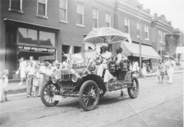
In November, we acquired a collection of 209 black and white amateur photographs taken in and around St. Louis between 1930 and 1980. Most of the photographs are from the 1950s and a large number feature parade scenes. Today we post two taken by the same photographer on the same date showing the intersection of Cherokee and Compton streets in south St. Louis.


The view in the first photograph shows the north side of the 3100 block of Cherokee Street toward the west end. At right are the buildings now housing Tower Tacos (3149 Cherokee) and Fort Gondo Compound for the Arts (3151). At left is the larger corner building where Peridot and the StyleHouse, housing clothing purveyors and St. Louis patriots STL Style and Lighthouse Design. Kuhn Upholstering Company is long gone. The Fort Gondo and Tower Taco buildings have lost their shaped front parapets. Overall, however, the view remains remarkably the same.


The second view looks north on Compton Avenue. Again, little has changed in the fifty-odd years since the parade passed by — just the removal of awnings. Even parades still pass by on Cherokee Street, at least around every Cinco de Mayo.

17 replies on “1950s Parade Scene, Cherokee at Compton”
There are words to describe how cool this is, but they aren’t appropriate for this venue! Thanks for this, Michael– what a trip!
So damn cool! I’d love to see more then and now views of STL, but thanks for starting with our block!
[…] This post was mentioned on Twitter by STL News, P.R.O.. P.R.O. said: [blog] 1950s Parade Scene, Cherokee at Compton: http://tinyurl.com/25s7btl […]
[WORDPRESS HASHCASH] The comment’s server IP (208.74.66.43) doesn’t match the comment’s URL host IP (74.112.128.10) and so is spam.
These photographs are fantastic. I love seeing street scenes of our neighborhood. Ryan Reed posted some from the ’70s at cherokeestreetnews.org (they are here) that you may have seen.
One thing about the second photo that you didn’t mention is the paved-over brick in the present-day version. There is still one brick paved street in the area that hasn’t been paved over: Virginia south of Cherokee. I’m wondering how rare this is in the city. Other than Laclede’s Landing I can’t think of any other brick paved streets that haven’t been covered. I’m sure there are some, but how common is this?
Re: brick streets. Off the top of my head: the St. in front of the Marquette pool house (Minnesota, I believe), Gasconade, from Minnesota to Iowa (?) at Laclede Park. Now that I think about it, there are alot of streets around the vicinities of both Marquette Park and Uncle Wouie (Gravois Park) that are still brick. Um, um, Virginia, just S of Uncle Wouie. Tennessee, east of Grand, S of Chippewa. Probably a few others. Very few of them are contiguous, as they run for a block or three to asphalt, or a dead end. I think that there are more around the vicinity of St. Cecilia, too. When you ride your bike around the City, I think it’s easier to note them. In the car, talking to friend(s): “Blah, blah, blah-blah-blee-blah-blah…Hey, did we just pass over a brick street?” “Huh. Dunno”. Cheers.
Oh, ps: can’t wait to see more of these pix.
Oh, pps: I think the pavers along the streetcar line on Cherokee are cobbles, not brick.
Before/after shots – – – always a winner. It must have been a fun scavenger hunt trying to find the exact spot to take the “today” shoot. Good work.
Great compare and contrast photos. — barbara
Michael, I’m currently in bed nursing the flu, so this is exactly what the doctor ordered! Much thanks for this, gg
The original thin metal awning remains on the Fort Gondo facade today, and it still serves its purpose (protecting pedestrians from pigeon droppings). Cool!
Virginia, N of Uncle Wouie. Mea Culpa.
Galen: Get well soon! Glad to brighten your day.
Jeff: Good catch on the thin awning’s still being there.
Chris: I think your observation on the loss of the brick street is good. Samizdat has laid out a good list of brick streets still remaining in the city. I’m going to throw open a thread on the subject with another post.
PS: All of my readers always make my day with their wit and insight!
Interesting lack of street trees in the before pictures.
They are nice photos and comparisons, what it really points to though is the importance of maintaining buildings and streetscapes. Jefferson Avenue from Park Ave to Lafayette Ave was lined with storefront buildings until the late seventies, I remember walking over from a house I rented on Missouri Ave and buying gooey butter cakes from the bakery from time to time. Now the row is gone and it is a useless, abandoned old mega grocery store with parking for the universe.
Instead of only requiring economic development at a single row building scale, redevelopment requires mega bucks (relative of course).
It would probably be fitting to have a moratorium on demolition until a reasonable city plan is in place to maximize the reuse of old St. Louis.
As your photos illustrate, reuse does occur, given the right circumstances.
And in fact that old row of commercial structures along Jefferson, if still in place and without their demolition: would probably have taken off economically by now, given the proximity of Lafayette Square and Soulard. Instead it is a useless, abandoned (Foodland I think) site, awaiting the magic touch of the guys who think they know everything over the diversity and multiplicity of the people.
Tremendous work! You own the talent of writing beautifully. I personally liked the way it has been drafted especially the perfect drafting of skilful thoughts.