Categories
Downtown Mid-Century Modern PRO Collection

Building the General American Life Insurance Company Building

by Michael R. Allen

Among the collections of the Preservation Research Office is a stock of amateur photographs showing changed in the St. Louis built environment at the last century’s middle point. Our collection draws from many anonymous urban gazers who took to the streets with cameras between 1935 and 1980. Toward the end of the chronology come the photographs of big late modernist buildings like the Bel Air East (1964; Hausner & Macsai), the Laclede Gas Building (1969; Emery Roth & Sons), Council Plaza (1965-1969; Schwarz & Van Hoefen), Pet Plaza (1969; A.L. Aydelott) and the General American Life Insurance Company Building (1977; Johnson/Burgee).

The General American building rises in the late 1970s. Undated photograph. Source: Preservation Research Office Collection.

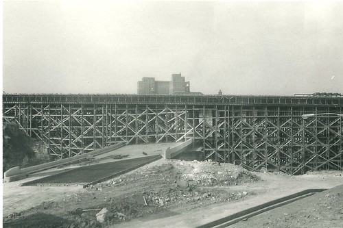
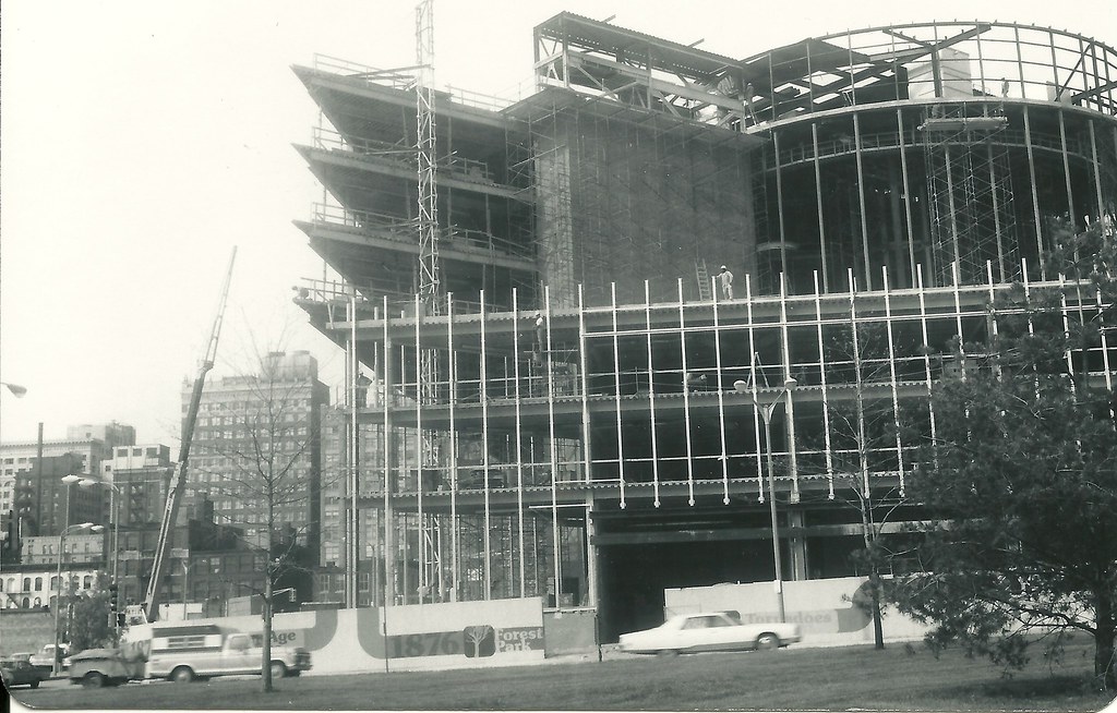
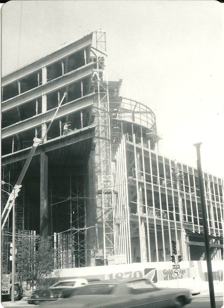
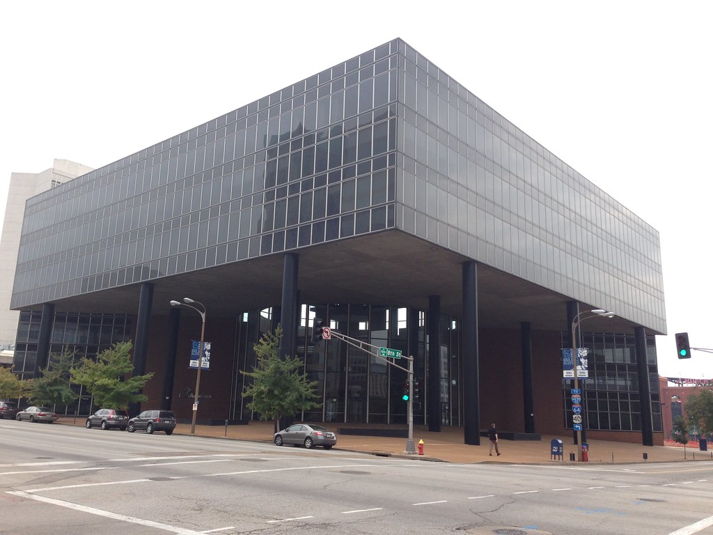
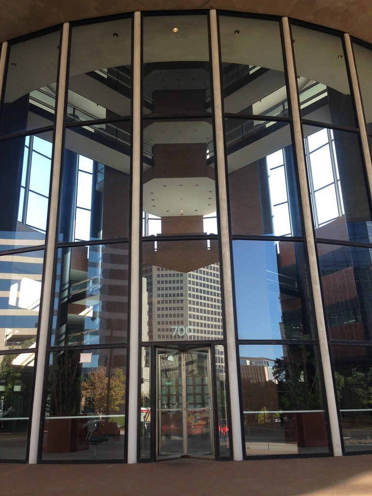
As the transfer of Laclede Gas from one downtown building to another sparks debate about the use of tax incentives to shuffle the downtown deck, we offer some views at the origin of the General American building. At the time of the building’s completion in 1977, the General American Life Insurance Building was a symbol of downtown corporate pride — the sort of pride that would have been wounded knowing that the building would require massive subsidy to be reused only 36 years later.

Old downtown meets new downtown, 1977 style. Source: Preservation Research Office Collection.

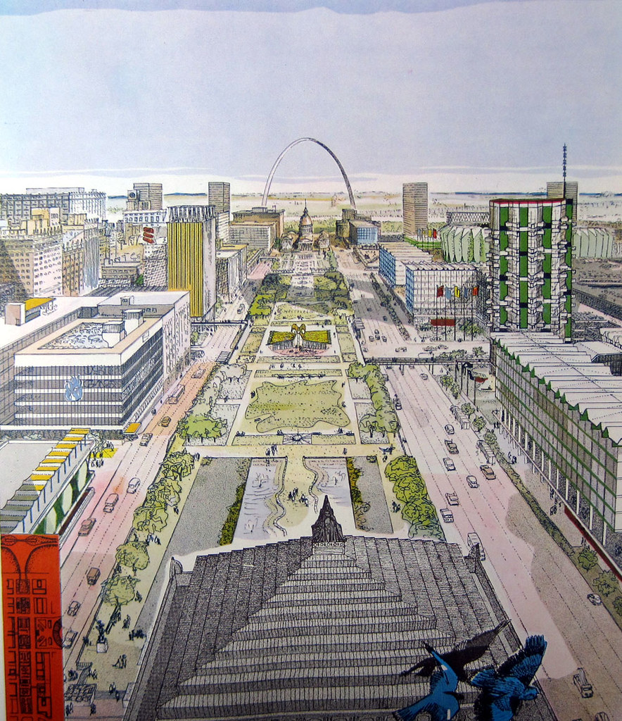
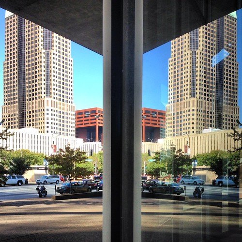
The General American building followed the heels of the city’s wishfully-triumphant attempts at creating a monumental corporate landscape around the Gateway Mall. City leaders yearned to make the Gateway Arch the focal point of a green swath framed by high-style office buildings that enshrined both the virtue of companies keeping their headquarters downtown and the ambitions of the city to build great buildings once more. General American’s headquarters fulfilled both, as did subsequent buildings along the mall path in their own more subtle ways. The mall itself proved to be the most challenging ingredient in the landscape.

Planes converging at Eighth and Walnut Streets during construction. Source: Preservation Research Office Collection.

In 1964 (the city’s proud bicentennial year), the city designed 42 blocks of downtown St. Louis as the “Civic Center Redevelopment Project” to be a new face of the city’s civic self. The project was created to realize the recommendations of the 1960 document A Plan for Downtown St. Louis, which outlines an intensive reconstruction of downtown’s eastern and southern ends. The Jefferson National Expansion Memorial landscape, where the Arch was nearing completion, was the primary impetus. The envisioned east-west park ribbon between Market and Chestnut streets was the second. By 1975, over $300 million in tax-abated development projects were complete in the area. Public subsidy’s roots in downtown development now extend to the origin of buildings potentially being subsidized in our era.

Bluebirds of happiness fly over a new park mall surrounded by corporate office buildings in this 1960 rendering from _A Plan for Downtown St. Louis_. Kurt Perlsee drew this perspective based on the plan’s recommendations.

Johnson/Burgee’s building would by far be the most impressive built in downtown for years to come; perhaps it has yet to be surpassed. The pair’s switch-cut of essentially a three story building into two cylinder-joined triangles killed the glass box. As CORTEX continues to produce ground-hugging, boxy buildings seemingly afraid of offending anyone’s taste, we should be examining the way in which the General American building transformed what could have been a dull low-rise office building into a sculptural work every bit suited for an important downtown site.

Philip Johnson and John Burgee flank General American President Armand C. Stalnaker as they examine a model of the new headquarters building in 1977.

When the General American Building was fresh, Nory Miller wrote that its components created
“a series of clear architectural pieces in locked combat with each other.” Johnson/Burge essentially twisted the Miesian glass box, defying an architectural era divided between reverent homages (Yamasaki’s World Trade Center, SOM’s Sears Tower) and heavy geometric abstraction (Roche & Dinkeloo’s Ford Foundation Building, Aydelott’s Pet Plaza in St. Louis). One year before the St. Louis building opened, Johnson/Burgee saw their ceremonial decapitation of the glass box, Pennzoil Place, completed in Houston. Johnson would won the 1979 AIA Gold Medal for his work at Pennzoil place.

Geometry — and material, with the red brick element — in conflict?

The General American building was a smaller break from modernist stricture, but not an insignificant one. General American’s completion in 1977 garnered critical acclaim from St. Louis Post-Dispatch critic Robert W. Duffy, who wrote that the “one of the most spectacular buildings to be built in St. Louis in years, and what is regarded as one of the most spectacular buildings to be opened in the United States in 1977.” In subsequent years, however, historians have not given the General American building a high rank in the Johnson/Burgee canon.

Looking at the building from inside of Citygarden at Eighth and Market streets.

When Melinda Winchester presented the National Register of Historic Places nomination for the building at the Missouri Advisory Council on Historic Places in 2007, the nomination caused a stir. Council members faced with a rather young building debated whether St. Louis possesses a fine example of the combined geniuses of Philip Johnson and John Burgee, or whether this was one of their minor works unworthy of the national designation before its fiftieth birthday. Ultimately, the building entered the National Register in 2008 (with an exceptional significance consideration), when it was 31 years old.

The entrance, looking into the soaring cylindrical atrium.
Postmodern is doubled in the reflections of the Metropolitan Square (1989; HOK) and St. Louis Place (1983) buildings on the glass lobby wall at the General American Life Insurance Company Building.

Today, the General American Life Insurance Company Building stands as testament to earlier civic optimism and corporate conviction in downtown’s future. The building preceded a small boom in construction that partially fulfilled earlier hopes for the Gateway Mall. Edward Larrabee Barnes’ 1010 Market Street (1981) and HOK’s One Bell Center (1987) maintain the trajectory set by Johnson/Burgee, while the Robert L. Boland’s Gateway One on the Mall (1985) is a glaring mediocrity. The architectural tenor of the Gateway Mall was improved tremendously a few years ago when Citygarden opened diagonally from the General American Building. Whatever happens to the tax increment financing proposed for the General American building, it remains one of downtown’s most inimitable recent landmarks.

We offer grateful thanks to our former intern Christina Carlson for scanning the General American construction photographs.

Categories
Downtown PRO Collection Riverfront

Riverfront Rodeo

Riverfront Rodeo. Source: Preservation Research Office Collection.

So, once upon a time, after the riverfront blocks were cleared (by 1943) but before the Merchant’s Exchange was demolished (1959), there was a rodeo where the Jefferson National Expansion Memorial is now located. the Exchange is located in the background right of the photograph, at the corner of Chestnut and Third (now Memorial Drive) streets. After demolition, the site was a parking lot. In 1982, the Adam’s Mark Hotel built a new building on that site.

This photograph is one of many amateur photographs in our collection, and is undated. If any readers know more about the rodeo shown in the scene, please post in the comments section!

Categories
Downtown Gateway Mall Mill Creek Valley PRO Collection

Parade Marching Through Mill Creek Valley

by Michael R. Allen

Another photograph from our collection of amateur images of the St. Louis built environment captures a parade moving westward down Market Street into Mill Creek Valley. The view was taken west of 21st street, and shows a panorama of the mid-century downtown skyline. Lacking a date, the image nonetheless offers a major clue: the surging waters of fountains around Carl Milles’ The Marriage of the Waters in Aloe Plaza can be seen at left. That installation was completed in 1940.

The image was taken before 1954, because the photograph shows blocks of vernacular, small-scale buildings between 18th and 15th streets that would be leveled for park space. Eventually this landscape would become the Gateway Mall. The buildings in the foreground would be leveled after 1959 as part of Mill Creek Valley clearance. Later, this area would be rebuilt with depressed on-ramps as part of the stalled North-South Distributor project.

Somewhere between the triumph of early intervention and later, more troubling urban renewal, a parade passed through this scene. The moment captured shows the African-American community of Mill Creek Valley in celebration, right in the heart of the city. By 1965, this community would be forever removed, and its built environment replaced by an uninspired landscape. Today city leaders have embraced the Northside Regeneration project, which calls for reconstructing the urban street grid west of Union Station and building dense infill there. Yet this photograph reminds us that architectural character is only the backdrop for urban cultural experience. Mill Creek Valley’s lively culture will never return to Market Street, and for that this city is worse.

Categories
Downtown PRO Collection

Twelfth Street in the 1930s

by Michael R. Allen

This amateur photograph may be out of focus, but its view is monumental: the Depression-era skyline of St. Louis, would-be metropolis of the Midwest. Looking north up the Twelfth Street (now Tucker Boulevard) viaduct over the Mill Creek Valley railyards, the photograph captures the hustle and bustle unfolding against the backdrop of the city’s earnest skyline. The date of this image is unknown, but it includes the Terminal Railroad Association’s Mart Building (1931; Preston J. Bradshaw, architect) and the Civil Courts Building (1930; Klipstein & Rathmann, architects for the Plaza Commission). At left is a glimpse of the J.C. Penney Warehouse (1928; T.P. Barnett & J.F. Miller, architects) and at right, obscured behind the Chevrolet billboard is the top of the Southwestern Bell Building (1925; Mauran Russell & Crowell with I.R. Timlin, architects).

Although these commercial and civic attempts to reach the sky were modest for the era, they are nonetheless beautiful and part of a fully urban scene. In the foreground, the viaduct receives repairs from a crew while the streetcar advances southward. Out of the frame, further south on Twelfth Street, would be some of the most densely populated blocks of south St. Louis. Although the city was suffering alongside the rest of the nation, its sense of purpose would not wane.

Our intern Christina Carlson digitized the photograph used here.

Categories
Benton Park West Cherokee Street Gravois Park PRO Collection South St. Louis

Cherokee Street Decorated for the Holidays, 1940s

by Michael R. Allen

Undated photograph showing the view down Cherokee Street east from Iowa Avenue. Preservation Research Office Collection.

These two photographs from our collection show two eastward views from the late 1940s down Cherokee Street around Christmas time. Amid the wreaths decorating street lights are an array of shoppers and so many projecting store signs that a count seems impossible. These photographs really make clear how much signs and marquees are visually interesting and worthy parts of the historic built environment, unfortunately now discouraged or effectively outlawed in commercial districts by zoning and local historic district ordinances. (Apparently turning on a stopped historic clock on Cherokee Street is even controversial to the city government, despite the clock’s clear role in the physical fabric.) An exact date for these two photographs, taken on the same roll of film, has not been determined but visual information likely set the year between 1945 and 1950.

Also present is the tension between modes of transportation. The streetcar, whose sign reads “Jefferson Line” in the photograph above, is dominant in the center of the street, but parked automobiles outnumber the streetcars and their rider capacity. Soon they would be the only motor vehicles on Cherokee Street.

Above, we see the Casa Loma Ballroom at left in its present appearance, which dates to reconstruction following a fire in 1940. The Dau Furniture Company marquee at left projects from a lavishly-detailed terra cotta front on the building at 2720 Cherokee (1926, Wedemeyer & Nelson). To its right is part of the former Cherokee Brewery. Almost every building in this scene still remains.

Undated photograph showing the view down Cherokee Street east from Ohio Avenue. Preservation Research Office Collection.

To the east at Ohio Avenue, the view is even more abundant with blade signs touting various stores and companies on Cherokee Street. The northeast corner building, now home to Los Caminos gallery, was the the home of the South Side Journal. Frank X. Bick founded the newspaper in 1932, and it is now part of the Suburban Journals with an office in West County. Other signs include those for Fairchild’s and Stone Bros. attached the a now-vacant building once operated by Anheuser-Busch as the Kaiserhoff, and one in the far background for Ziegenhein Bros. Livery & Undertaking Company. Visible diagonally across the street from Ziegehein Bros.’ building is the sign of 905 Liquors, housed at Cherokee and Texas in what became the home of Globe Drugs. At the time this photograph was taken, murals by artist J.B. Turnbull adorned the walls of that particular location of 905.

Categories
Downtown PRO Collection

Washington Avenue at Christmas, Circa 1965

by Michael R. Allen

From the Preservation Research Office Collection.

This photograph captures the reflection of a Christmas castle and part of the Stix, Baer & Fuller Grand Leader store building (1906, Mauran Russell & Garden; 1919, Mauran, Russell & Crowell) spread across Washington Avenue. The view is looking southeast from Sixth Street, and the procession of buildings on the south side of the street is pretty clear despite the visual accident. The view down Washington is terminated by the elevated lanes of Interstate 70, completed in 1964, so the date of this photograph — unmarked and unrecorded — is 1964.

At right, we have the S.S. Kresge store at Broadway and Washington, which opened in its streamline-slipcovered building 1939. Across the street and to the east is a surface parking lot where the B. Nugent & Brother Dry Goods Store had stood until just a few years prior. That lot gets a view of the side wall of the J. Kennard & Sons Carpet Company Building (1901, Isaac Taylor), which otherwise presented elevations articulated and adorned in the manner of the Italian Renaissance. That building would later be expanded by the Edison Brothers Company after they moved their headquarters there. The Nugent site would give rise to the studious but dour modernist mass of the 500 Broadway Building (Smith-Entzeroth, 1970).

Further east, this photograph includes a rare glimpse of a seven-story commercial building that once stood at the southeast corner of Fourth and Washington that was once home to Trorlicht-Duncker Carpet Company. That building was demolished in 1966 to make way for the northernmost of the three-story Mansion House Center office buildings (Schwarz & Van Hoefen, 1967).

Categories
Clearance Infrastructure JNEM PRO Collection Riverfront South St. Louis Urban Renewal Era

Photographing the Changing Face of St. Louis

by Christina Carlson

I recently had the opportunity to digitize several photographs for the Preservation Research Office spanning from the 1930s to the 1980s. The photos consisted primarily of pictures of historic buildings and other structures in St. Louis, but also included were snapshots of parades, fairs and local people. Although many of the photos were of great interest– revealing buildings, people and spaces now forgotten — a few in particular caught my attention.

The Old Cathedral amid riverfront clearance around 1942. Photographer unknown.

At first glance this snapshot appeared to me as nothing out of the ordinary, simply another picture of the substantial efforts at demolition which took place in mid-century St. Louis. However, on a second look I recognized the iconic nature of this photo. The church in the center of frame is The Basilica of St. Louis, King of France, which sits adjacent to the Gateway Arch ground. I realized that this image captures the moment of destruction for a large swath of the riverfront area which began in 1939 and ended by 1961. Despite the conjecture of many who saw the riverfront area as a vital, ethnically and cultural diverse area, demolition of some of the oldest buildings in St. Louis was approved in 1939. In a twist of irony, much of the Eastern portion of the city was destructed to make way for a memorial to Westward expansion.[1]

Construction of the ramps connecting Interstate 44 to Interstate 55, circa 1964. The City Hospital is in the background. Photographer unknown.

Another photo I noted was one on the opposite end of the spectrum, as it portrayed the construction of the lanes of Interstate 44 where it merges into Interstate 55 south of downtown St. Louis. This image evokes a different moment in the city’s history, one in which it suddenly became much easier for those in the rapidly expanding suburbs to reach downtown, and to leave it. Although the history of suburban development in the post-war years is well known, the story in St. Louis was particularly evident. As the population shifted outward, many buildings within the city were demolished, leaving in their wake parking spaces and empty lots.

Side by side, these two images powerfully convey prominent themes in the history of St. Louis: the destruction of older, more diverse districts and the construction of vast networks of suburbs, supported by the presence of major freeways bypassing downtown. Although there are a variety of themes present in the photographs I digitized – family ties, segregation, religion, wealth, poverty – none were so prevalent as the drastic restructuring of the face of the urban landscape in St. Louis in the middle of the twentieth century.

Categories
PRO Collection South St. Louis Tower Grove East

Snow Day on Gravois, c. 1960

Photograph from the Preservation Research Office Collection.

This photograph dates to around 1960 and shows a woman walking north on the west side of snow-covered Gravois Boulevard just north of Cherokee Street. In the background, faintly, the neon-lit blade sign of F.W. Clemens Supply Company can be seen — a sign that remains to this day. Clemens still sells bulk materials like mortar, cement, gravel, minus and sand to contractors and enterprising individuals.

Categories
Demolition Downtown PRO Collection

Live Better Electrically

by Michael R. Allen

One of the photographs in our recent acquisition of over 200 amateur photographs of St. Louis shows the Union Electric Building at 315 N. 12th Street (now Tucker Boulevard) decked out with holiday decorations. The photograph is undated but comes from the middle or later 1950s. There was plenty to see the rest of the year

In the 1950s, Union Electric’s headquarters was decorated year-round with an impressive neon-tube sign mounted on a rooftop structure. By 1953, Union Electric had purchased the adjacent St. Louis Star-Times building to the south. The image above comes from the Summer 1953 issue of Union Electric Quarterly and shows the sign atop the Star-Times building.

Both the St. Louis Star-Times and Union Electric buildings were demolished in the early 1980s and the site (on the same block as Christ Church Cathedral) is now occupied by a tiny U.S. Bank branch building and more asphalt. There are no illuminated holiday decorations, no neon signs and no sign that great buildings ever occupied the site.

Categories
Benton Park West Cherokee Street Gravois Park PRO Collection South St. Louis

1950s Parade Scene, Cherokee at Compton

by Michael R. Allen

In November, we acquired a collection of 209 black and white amateur photographs taken in and around St. Louis between 1930 and 1980. Most of the photographs are from the 1950s and a large number feature parade scenes. Today we post two taken by the same photographer on the same date showing the intersection of Cherokee and Compton streets in south St. Louis.

A parade heading west on Cherokee Street near Compton Avenue in the 1950s. Photographs from the Preservation Research Office Collection.
The same view today.

The view in the first photograph shows the north side of the 3100 block of Cherokee Street toward the west end.  At right are the buildings now housing Tower Tacos (3149 Cherokee) and Fort Gondo Compound for the Arts (3151).  At left is the larger corner building where Peridot and the StyleHouse, housing clothing purveyors and St. Louis patriots STL Style and Lighthouse Design.  Kuhn Upholstering Company is long gone.  The Fort Gondo and Tower Taco buildings have lost their shaped front parapets.  Overall, however, the view remains remarkably the same.

The parade turned south onto Compton Avenue from Cherokee Street.
The same view today.

The second view looks north on Compton Avenue. Again, little has changed in the fifty-odd years since the parade passed by — just the removal of awnings. Even parades still pass by on Cherokee Street, at least around every Cinco de Mayo.