Categories
Industrial Buildings Infrastructure Mississippi River North St. Louis

Joseph F. Wangler Boiler & Sheet Metal Works

by Michael R. Allen

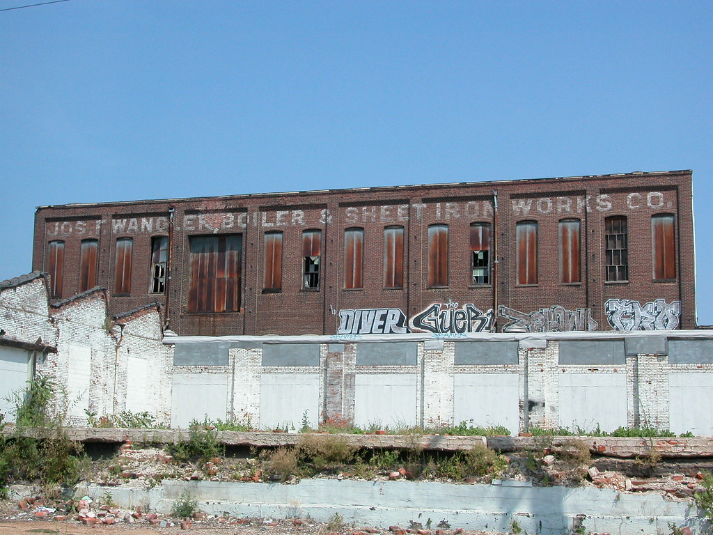
I report with relief that the latest footprint of the proposed Mississippi River Bridge at St. Louis reduces the number of historic buildings proposed for demolition to less than six. (Alas, the footprint will cover the site of the “big mound” at Broadway and Mound streets, which is potentially one of the city’s most significant Native American archeological sites.) One of the buidlings in the path of the ramps connecting the bridge to Cass Avenue is the complex once occupied by the Joseph F. Wangler Boiler & Sheet Metal Works Company, located on the superblock (Mullanphy is closed) bounded by 10th, Howard, 9th and Cass. Much of the complex dates to mid-20th-century expansion, but at the core is a taller 19th-century brick building bearing the name of the company.

The Wangler works warranted a mention in E.D. Kargau’s 1893 Mercantile, Industrial and Professional St. Louis. Kargau noted that among St. Louis’ many industrial concerns are but a few boiler makers, Wangler being one. The Wangler works started in 1864 as Cantwell & Wangler before falling under control of Joseph F. Wangler, a Pittsburgh native. The first location was at 1019-23 Main Street, but the firm need space and moved west to the block where its name can still be read.

According to Kargau, the Wangler shops “are equipped with the most approved and modern machinery and the work turned out from them is unsurpassed in exact workmanship, durability and quality of material and are always closely examined before being sent out” (page 295). Among these renowned works were, of course, boilers as well as sheet iron work, storage tanks and tanks for ice machines.

Kargau had much praise for Wangler and his sons as business leaders, stating that they “are at all times ready to participate in every movement for the welfare and in the interest of the community” (page 296). Long gone are these men, their company and the spirit of enlightened civic business culture. We have only a few buildings from the boiler works to remind us of the Wanglers’ good work, and not for more than another decade. Some may find a new bridge to be a work in the interest of popular welfare, but the fruits of employment found at the boiler works provided more bread to the common person than the new bridge ever will.

Categories
Historic Boats Historic Preservation Mississippi River Riverfront

Pinnacle Chief: S.S. Admiral Has "A Few Years Left"

by Michael R. Allen

Yesterday’s article in the St. Louis Post-Dispatch on the fate of the S.S. Admiral (“Boat my move north” by Gail Appleson) reported on both the short-term and long-term fates of the Art Moderne vessel. Pinnacle Entertainment, owner of the boat, plans to move the Admiral to a site just north of the Chain of Rocks Bridge. This move could take place in 2009, if the Missouri Gaming Commission approves.

The more troubling news comes in a quote from Pinnacle Chief Executive Office Dan Lee. According to Lee, the Admiral is close to needing its 100-year-old-hull (the Art Moderne section was built atop an existing 1907 hull) rebuilt, and Pinnacle has no interest in making that repair. Lee told the Post that re-hulling “wouldn’t be economical” but he thinks that “there are a few more years left on that hull.” How long the S.S. Admiral can survive remains uncertain.

Categories
Downtown Mississippi River Riverfront

Pinnacle Third Quarter Report Mentions Admiral Relocation

by Michael R. Allen

Pinnacle’s third quarter earnings report, released yeterday, contains this sentence:

The Company is evaluating the feasibility, subject to gaming commission and other regulatory approvals, of relocating The Admiral Riverboat Casino to another location within the city of St. Louis.

Categories
Agriculture Events Mississippi River North St. Louis St. Louis Place

St. Louis Place Alive With Thursday Night Concerts

by Michael R. Allen


Headliner Kim Massie thrilled the large crowd at the Thursday kick-off of the Whitaker Foundation/Grace Hill Urban Evening Series at St. Louis Place Park in north St. Louis. Massie’s blues-oriented programs deviated for a crowd-pleasing cover of Gretchen Wilson’s “Redneck Woman,” showing that music can knock down any supposed cultural divide. Gene Dobbs Bradford & Blues Inquisition opened.

This is the year for the series at St. Louis Place. St. Louis Place, laid out in 1850, is one of the city’s oldest and most beautiful public parks. The music energized the neighborhood, with residents of Rauschenbach and 21st streets flanking the park hanging out on front stoops to get an earful of tunes.

Concerts run each Thursday at 7:00 p.m. in St. Louis Place through July 24; full schedule here.

The joy of Thursday night came on the heels of national publicity for the neighborhood to the east, Old North St. Louis. The acclaimed conservation group the Natural Resources Defense Council’s blog featured a laudatory entry by its Kaid Benfield, director of the council’s Smart Growth program. Benfield’s post “Of the community, by the community, and for the community: the rebirth of Old North Saint Louis” celebrates the community-driven resurgence of downtown’s northern neighbor.

Meanwhile, the North City Farmers’ Market featuring produce from St. Louis Place’s New Roots Urban Farm, started on Saturday, June 7 and runs through October 25. Each Saturday from 9 a.m. until noon, people can purchase fresh food and enjoy cooking demonstrations at the intersection of 14th and St. Louis in Old North.

On top of all of this, the Mississippi River flooding has avoided the popular North Riverfront Trail, which remains open and accessible east of Old North.

Residents of the near north side are having a great summer — good music, the world’s coolest urban trail, a farmer’s market and awesome music usher in a pleasant season.

(Photographs by Lynn Josse.)

Categories
Art Mississippi River Transportation

The Facts Behind the Rumors of Miss Rockaway Armada

KWMU’s Maria Hickey interviewed Coast Guard Commander Mark Cunningham about the incident involving Miss Rockaway Armada; listen here.

Categories
Art Mississippi River Transportation

Miss-hap

by Michael R. Allen

If your hand-made river vessel, powered by wind, bio-diesel and sun and made of junk, sadly happened to fall apart in the river, you probably couldn’t have better fortune than to have that happen near the city of St. Louis. St. Louis teems with scrappy mobs of ingenious anarchist inventors, bands of starstruck architects, teams of poetic moonshiners and do-it-yourselfers who know how to rebuild even whole neighborhoods.

I think that Miss Rockaway Armada has found the perfect port to recover from strange misfortune. No doubt that the good crew will be afloat one way or another within a few days.

Categories
East St. Louis, Illinois Granite City, Illinois Infrastructure Metro East Mississippi River

New Bridge Could Widen the Gap

by Michael R. Allen

In a St. Clair County Journal article discussing the possibility of tolls being imposed on the proposed Mississippi River Bridge, mayors and alderpersons of several different Illinois cities were quoted, and all favor the new bridge. The mayor of Granite City, Ed Hagnauer, thinks that the new bridge will bring Missourians into Illinois.

One city rarely mentioned in discussions of the new bridge, and without an elected leader quoted in the article, is East St. Louis. Perhaps this neglect is due to the fact that new bridge has no real physical connection with East St. Louis, and will instead divert I-70 from even passing through the old city. The new bridge’s backers tout the economic growth it will bring to Illinois, but overlook or dismiss the inequity such growth will bring. Cities farther east, liked Edwardsville and Collinsville will benefit greatly from a quick route connecting their new strip malls and office parks to the moneyed residents of St. Charles County. This economic flow will miss older cities close to the river, like East St. Louis and even Granite City — cities that face depopulation, widespread poverty and a lack of economic growth. The bridge will allow the haves to gorge on growth while ensuring that have-nots continue to remain economically malnourished. It will carry people over the old cities and their minority populations, just as the highways built in the late twentieth century did for larger cities.

Proponents of the bridge dodge the issue. The bridge will spread the sprawl eastward, and balance out the effect of the far-west suburban growth in St. Charles and Warren counties. But it will be creating a distribution pattern resembling a donut, fueling new growth on the edges of the east side’s developed area instead of helping redensify the inner core of east side cities.

East St. Louis is left out, again. Why not? Dealing with its problems is too difficult and requires careful, long-term action. Preventing exurban growth requires strong will on the part of politicians, who would have to tell their big-bucks backers “no.” Building a bridge gives everyone a relatively quick dose of what they want: faster profits on new east side development, a short-term decrease in commute time between far suburbs in Illinois and Missouri and a fancy new structure to experience from a car.

Categories
Carondelet Green Space JNEM Mississippi River Riverfront

How Do You Get to the River?

by Michael R. Allen


It’s late in January and I find myself slipping on the ice. I am walking down a deserted city street that runs near an abandoned industrial complex. Few cars travel this street, but luckily one has driven here recently, or I wouldn’t have the fortune of walking in the tire tracks that save me from a fall. Still, I can’t avoid slipping every few minutes.

Why am I enduring this desolate and dangerous walk on one of the coldest winter days of this season? I am looking for access to the Mississippi River in the city of Saint Louis. Such a search requires patience even when one knows where to go, as I do. Beyond the public and dirty river access provided at the levee parking lot at the foot of the Arch grounds, all other access points require a little bit of walking.

There is an almost-inaccessible short promenade at the foot of Bellerive Park, but the last time that I tried to go there I found construction equipment in my way. Technically, that promenade is the only park in the city that offers access to Old Man River. It’s odd that the city doesn’t even post any signs in upper Bellerive Park pointing out how to get to the riverside.

Yet its even more odd that a city with a riverboat on its city seal, that was a pivotal seat in the river-based exploration of the Western United States and that was once a prosperous inland port does almost nothing to point out that the Mississippi River is more than just an iconic legend around here. Even Downtown Now’s new signs, which readily point out places where people can spend money, do not point out how to get to a place where one can sit by the peaceful flow of muddy water that was so important to the city’s founding and commercial development.

Signs really wouldn’t help much, though, because they could only point to access that doesn’t exist. Much of the riverfront in the city consists of concrete floor walls or industrial tracts such as my favorite river-watching spot. And the ostensibly grand civic riverfront of the Jefferson National Expansion Memorial has been host to burger barges and a shabby surface parking lot in the last twenty years. City planners have gradually cleared the riverfront of moored vessels, but they have never studies moving the parking lot.

South of the Arch grounds, one can walk though the usually-open gates on the flood wall and get to the river, but then the whole sense of the urban world disappears as one stands between a tall wall and a river. This is a bit more intimate spot than the access offered in front of the Arch grounds and Laclede’s Landing. There are no cars. But then again, there aren’t likely to be any people and hence the experience is rather cold. Engineering thwarts the potential for an urban river outlook.

Elsewhere in the city, people don’t have many choices. The north riverfront trail offers many good vantage points and in a few places provides points of access. These points, however, entail walking down banks and even trespassing. They aren’t fully public. Around the Chain of Rocks Bridge, once can get fairly close to the thicket of trees and foliage growing near the riverbank, but without a machete won’t get too far.

Then there is my favorite place, which I want to keep a secret. This place is not easy to get to, but it provides a clear vantage point far from automobiles and flood walls. I can see the city behind me and the river in front of me, and I can sit down and listen to the river. I don’t feel good about having to keep this place private, but it’s not my choice. Like 96% of the rest of the city’s riverfront, it is not a public space in the eyes of the law. Of course, all of the riverfront is natural public space. The Mississippi is the city’s greatest natural resource, despite its forces removal from the lives of Saint Louisans.

We have turned our backs on the Mississippi River because it no longer is the backbone of our commerce. Like the railroads, the river is a commercial casualty of the interstate highway. But that’s fine, because the river is a natural force that would much rather beckon weary city dwellers to its peaceful banks on a cold January day than be clogged with steamboats and barges. It’s time for us to cooperate.