
by Michael R. Allen
This blog continues to chronicle the loss of north St. Louis building stock. Our goal is to illuminate the repetitive impact of careless demolition policy, and the social impact of individual demolitions. There is a special problem posed by demolitions in neighborhoods that are proximate to parts of the north side that have retained architectural integrity and are already listed or eligible for listing in the National Register of Historic Places.
Demolitions across the north side don’t just remove problem properties. They remove housing stock and reduce the voter rolls. Demolitions destabilize neighborhoods. They erode sense of place, which turns owner-occupants away from neighborhoods, or north St. Louis entirely. Demolitions and persistent vacant lots lower land values. Expedient, perhaps. Damaging, for sure. The long-term impact of demolishing vacant buildings is the fulfillment of the “Team Four Plan” mythology: a depleted half-city easy to dismiss and lacking in density needed for truly flourishing urban life.
Yet the culprits for the outcome are not consultants hired forty years ago, but rather aldermen and Building Division staff who put city resources behind the destruction of north side neighborhoods. Long-term planning is subsumed by knee-jerk response: tear it down, tear it down, tear it down. That phrase then whispers in the weeds, maybe forever, as neighborhoods from College Hill to The Ville end up with more vacant lots than buildings. With city population shrinking, it is entirely possible that these neighborhoods might disappear forever. Without retention of building stock, these places don’t stand a chance of surviving — but will become the dreamscapes of developers with big plans.

4347-49 College Avenue: Another Day, Another Demolition
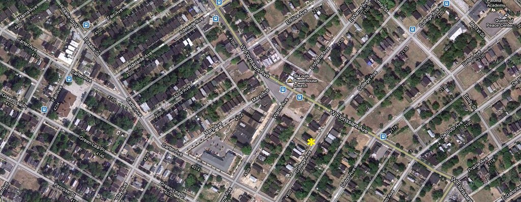
The 4300 block of College Avenue is a typical block of late 19th and early 20th century St. Louis vernacular masonry buildings. Unlike surrounding blocks in Fairground, most of the buildings still stand with proud red brick walls, ornamental brick tracing and the occasional slate-clad mansard roof. The setting certainly is one of those that combines with others to form a major city with unique, irreplaceable character.
Back to the specifics: two buildings have been torn down on this block in the last month. One of these buildings is a three-story multi-family building at 4347-49 Warne Avenue, under demolition right now. On April 2, the Building Division issued the demolition permit to the city’s Land Reutilization Authority, and work started mid-May. The reason for demolition? The back wall had spalled off a lot of its brick, leaving a gaping hole. Yet the building was otherwise intact, and the damage was not structurally threatening.
The Land Reutilization Authority acquired the building in 2000 after the prior owner, Sovereign Realty 1984-V Partnership, defaulted on its property taxes. If that corporate name is unfamiliar to readers, the name of at least one of its general partners won’t be. Sovereign Realty 1984-V Partnrship’s 1984 filing for fictitious name registration lists Floyd C. Warmann and Jesse Horstman as the company’s two partners. City records show that the building stood vacant since 1992.
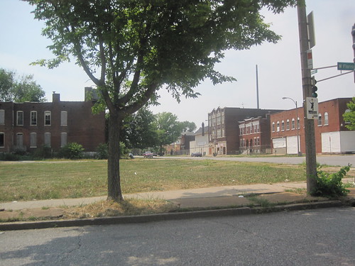
For a building that was vacant so long, this one was in remarkably good condition. This block’s location just south of the O’Fallon neighborhood, one of north city’s most intact architectural settings, makes it a key bolster. The back wall of the building at 4347-49 College Avenue was part of the viewshed from the commercial district at Warne and West Florissant avenues. Yet demolition in the Third Ward, in which encompasses the Fairground and College Hill neighborhoods south of O’Fallon, continues rapidly. Warne Avenue is the neighborhood boundary between these depleting areas and O’Fallon, which is on the oath to becoming a National Register of Historic Places historic district. Warne Avenue is fast becoming the edge between an area being conserved and an area that may be depleted beyond recognition in the next decade. That is not good for either side of the line.
Another Way
What is happening in O’Fallon, driven by Alderman Antonio French (D-21st) and residents, is the antidote to decades of north St. Louis depletion. French’s first bill placed the ward under demolition review, extending the power of the Cultural Resources Office to block needless demolition (most cases). Then the alderman funded survey of the neighborhoods leading to historic district nominations, which will enable historic tax credits to be used in the neighborhood while providing some official protection of the great buildings of the neighborhood.
Nothing is guaranteed through implementing preservation policy, except that the building stock will be retained while economic development planning occurs. O’Fallon won’t end up a sea of vacant lots dotted by a handful of remaining buildings. Would that more of north St. Louis — and there are many great parts — follow the same path. The creation of stark contrasts in neighborhood condition where there are formidable physical edges don’t help.
Following that path means being patient. North St. Louis was built up with great buildings over the course of at least 150 years, and its decline has been ongoing for at least 60 years. Reversing that decline won’t be completed within a four-year aldermanic election cycle, even stretched over three terms. We have to think in spans of generations when we think about building cities. North St. Louis will reborn for its children, and their lives will be shaped by how it gets treated today.
13 replies on “Demolition and Boundaries in North St Louis”
From what date do urban historians date the demolition of North St. Louis? Was it a specific public works project that started it 60 years ago?
1950-ish.From Wikipedia: Â
http://en.wikipedia.org/wiki/Urban_renewal  Title One of the Housing Act of 1949 kick-started the “urban renewal” program that would reshape American cities. The Act provided federal funding to cities to cover the cost of acquiring areas of cities perceived to be “slums.” (The Federal government paid 2/3 of the cost of acquiring the site, called the “write down,” while local governments paid the remaining 1/3.) Those sites were then given to private developers to construct new housing. The phrase used at the time was “urban redevelopment.” “Urban renewal” was a phrase popularized with the passage of the 1954 Housing Act, which made these projects more enticing to developers, by among other things, providing FHA-backed mortgages.http://library.cqpress.com/cqresearcher/document.php?id=cqresrre1963082100Â
Wait a minute, in a previous post you stated it was a good thing that College Hill was left out of the preservation review, but now you’re criticizing the demolition of a building in that very neighborhood? Please explain.
And besides, Housing Conservation Districts are a complete joke in the city of St. Louis. None of the slumlords are ever forced to fix up anything around me–in fact, a supervisor overruled a building inspector’s decision to condemn a drug house for occupancy across the street from me.
Here would be a good way to reduce Alderman induced demolitions – New rule: Once a ward becomes 50% depleted of buildings, it is eliminated and ceases to be a ward, with the property then being distributed evenly to adjacent wards.Â
In this article, I was taking as a starting point the findings of the City Plan Commission reported in the 1947 Comprehensive Plan. That document included infamous maps of the city with “obsolete” areas shaded. Proportionally, the difference between the parts of north and south city given that designation is vast.Â
That makes some sense. Another thing that makes sense is replacing wards with service districts and electing council members at large, from the city’s entire voting population. That way, depletion would not affect representation.
In my previous post, I suggested that the standard of review in College Hill should be different than in intact, dense neighborhoods. In that same post, I reiterated my strong support for returning St. Louis to citywide demolition review. My point was not that all of College Hill should be reviewed as if demolitions had no impact, but instead that denying permits in intact areas was very important (and that there were blocks where denial would make no positive difference in retaining already-lost architectural character).
Here, I am criticizing the demolition of a building in Fairground. Fairground has been depleted in parts but collectively has greater density than College Hill. There are areas of the neighborhood that may be eligible for historic district designation. Furthermore, there are blocks like the 4300 block of College that are intact enough to deserve preservation regardless of whether they can be included in a National Register district.
You are right, the whole city should be under demolition review. Where are the aldermen/women making such a proposal? Of course there is no doubt many business interests in the region that wouldn’t want to see St. Louis City to rebound either.
I don’t have a problem with the fact it takes time to build cities. The real problem is the path of 60 years of City decline is still in place. Until that changes there may not much of a City left for the next generation.
It sounds like Alderman French is taking actions to help his ward, that is great, but if city wide issues are ignored due to territorial issues, in the end it will doom other efforts. I can remember in the early 80’s when it looked like Hyde Park might take off like Soulard. It didn’t happen in spite of a great deal of activity in that neighborhood.
The aldermen/women need to forget territory and take care of St. Louis as a whole. They should definitely look at the City transit system. In fact attractive transit is one of the major losses of the continual demolition.
Forget the experts, Metro, East West Gateway Council and the rest. The aldermen/women should understand the role of transit in rebuilding the city and demand better outcomes that we are getting now.
Without city wide focus O’Fallon Neighborhood could end up Hyde Park and revert to decline. True aldermanic influence over the planning process, making it a public debate could also finally also generate answers about McKee and the standards he has to meet to build in St. Louis.
 “I can remember in the early 80’s when it looked like Hyde Park might take off like Soulard.” Word. I remember that as well. I suppose we can thank Dick Gephardt and the 1986 Tax Reform Act for that. Pretty much stopped rehabbing/restoration cold in the City.
You could conceivably go back even further to trace the political evolution of the process. Demolition in the ’50s was just the most recent incantation of what those at the time saw as an inevitable, even natural process, of urban decline. The perceptions that shaded the maps of 1947 can be traced back a decade earlier. The 1936 St. Louis Regional Planning Report stated “The older residential districts which are depreciating in value and in character constitute one of the most serious problems of the region… Even if owners wished to build new homes within them, it would be inadvisable because of the present character of the districts.” One year later, the Home Owners’ Loan Corporation employed local bankers and appraisers to survey the region and in the surveys from 1937 and again in 1941 the HOLC gave the neighborhoods on the near north side of downtown the lowest ratings of C and D. The FHA adopted the HOLC’s ratings in determining what neighborhoods could receive federally-insured home loans. C and D neighborhoods received few loans for either new construction or property improvement. I would bet that if we overlayed the maps and plan  the C-D rated neighborhoods from HOLC’s 1937 and 1941 Residential Security Maps would match the shaded obsolescence in the 1947 Comprehensive Plan.
 Informative and interesting, I have believed for a long time the destruction of St. Louis was not accidental, but calculated. Finding the time to research the various actions undertaken in the past is a real effort.
Of course destruction is always easier than building, and is why St. Louis still languishes as the current misguided governance continues the wholesale demolition of Old St. Louis.
(There is no effort to present a coherent plan or idea for public debate, none, absolutely none).
But it is good to see this information.
If I had to sum the problem up in one word it is oil. And the oil interests still rule St. Louis and America.
Michael: The HOLC surveys indeed are an earlier indicator than the 1947 report. Plus, the 1947 plan’s recommendations are based on data collected by the City Plan Commission in the 1930s. One can even go back further to the recommendations of the Civic League in the 1907 plan to see a consensus emerging about the deterioration of the north side east of Jefferson. For my purpose, however, I selected the date in which public policy was adopted that made clearance of the building stock a target.
The policy that mandates the destruction of housing that is valuable and that will never be replace is what is de-populating the city…The electeds need to look at the past and and make rules that preserves housing stock and regrow the city….The electeds ignorance and arrogace makes them complicit in smothering a once great place to live and work….Mill Creek…..the West End….sad news