by Michael R. Allen

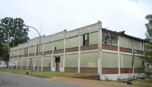
I just submitted a National Register of Historic Places nomination for the Alligator Oil Clothing Company Buildings, early reinforced concrete industrial buildings designed by Leonhard Haeger (architect of the possibly-lost Pevely Dairy Plant office building). Some readers may recognize the mighty factory building on the northern edge of the Bevo neighborhood, which stands on Bingham Avenue between Gravois and Morganford. Built in 1918 and 1919, the two contributing buildings use the Turner “mushroom cap” structural system, and the main building is a very unusual early example of a fully-exposed exterior concrete structure. More on the Alligator plant later — now I want to show a neat discovery.

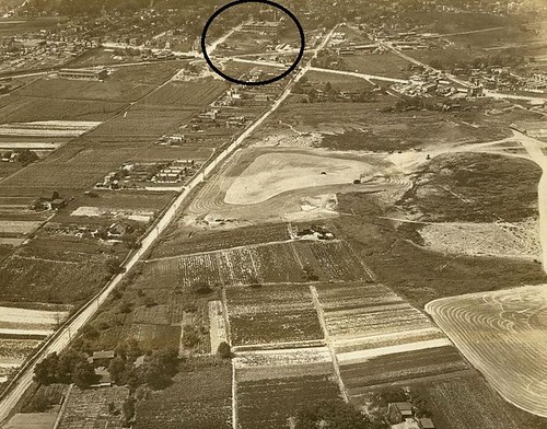
In researching the building, we needed photographs showing that the Alligator buildings retained what the National Register defines as “integrity” — essentially, whether the buildings still convey the attributes that they displayed in their historic period. Tracking down historic photographs was difficult, but we managed to fine one view showing the main Alligator building in 1918, thanks to the St. Louis Building Arts Foundation. The date is clear because the smaller eastern building completed in 1919 is not evident in the photograph.
The view looks west down Meramec Avenue. The diagonal road running across the photograph is Gravois. Chippewa Avenue is seen at right, running diagonally toward the top of the frame. An intersecting diagonal running toward the right top of the frame is the former St. Louis, Oak Hill and Carondelet Railroad line. The Alligator plant is marked with a dark circle. Contrasting with the one-story flat-roofed houses sprouting on subdivisions lots is the dominant feature of the images: the contours of row cropped farm fields. Less that 100 years ago, the area around Chippewa and Gravois was nearly rural.

5 replies on “The South (Country) Side”
Eric Friedman was trying to figure out what to do with the building some years ago, I guess no solutions yet. Even though it is a central site it is out of the way. Then any integration with the surrounding residential neighborhood makes the task more difficult.
The intersection of Gravois and Chippewa looks to be built up in the photo, otherwise it shows mostly open space with scatterings of residential, including around the alligator.
I tried to do a quick search for the population of St. Louis at this time, but couldn’t find it.
Interesting history, and yes the rural in the area is amazing, Today agriculture is a distant thought in the corporate grocery aisles.
Amazing building too!, wasn’t there another one that burned down?
I think this is the building in which Bicycle Works stored thousands of donated bikes in the 90’s, until the vast majority of them were shipped to Central America for sale/donation. So many bikes! So many to move!
I think one of these was torn down last year, and as gmichaud notes, I believe it was due at least in part to a fire. If there are those who are unsure where these are, they are basically behind Chauvin Coffee and that apartment complex on Meramec. As Mr. Allen has already stated, the route to this group almost needs a password to locate.
Oil clothing was basically the only weather/rain resistant/proof outerwear available at the time these buildings were erected, at least until synthetic products were widely available. I would guess that in addition to outerwear, some production was devoted to providing protective gear to industry, such as those which used dangerous chemicals and/or processes: tanneries, foundries, refractories, brick manufacturing, etc.
A connector between the two primary buildings caught fire in 2001 and was wrecked. That section dated to 1943 and was not part of the original plant.
Eric is working on new plans for the site, and that is why we are preparing the nomination. The location is close to a lot, but circulation is an issue. On the whole the surrounding area is cut off by Gravois and the railroad viaduct. Of course, that makes the area pretty quiet and peaceful. Residential at Alligator would work well.
The section of the building that burned in 2001 was a connector built in 1943. It ran between the original Alligator plant and the building built in 1919, which was leased to the P.D. George Company. The George company made varnishes and paints in co-production with Alligator.
Up until the 1920’s there were still larger areas of the city that were fairly rural. Is there much information available that documents what the rural areas were like? Were there communities? What happened to the farmsteads? How old were many of the rural homes? Any of them still exist? Just something that I have always wondered.