Postmodernism’s preservationist audience has yet to emerge, but when it does it may find solace in the fact that not all of St. Louis Centre was altered in its parking garage transformation. On the top level of the garage, now called the Seventh Street Garage, remains the barrel vault skylight that once illuminated the mall atrium. The atrium’s openings have been infilled by new floor plates, and the interior’s white and green supplanted by the gray din of utility, but the lighting remains beautiful.
Preservation Research Office is pleased to be one of the sponsors of Open/Closed: Exploring Vacant Property in St. Louis, the second annual St. Louis vacant property conference. This year’s conference offers a multi-day schedule that includes panel discussions, workshops, film screenings and activities in north city’s O’Fallon neighborhood.
Last year’s conference laid the groundwork of awareness of how vacancy affect St. Louis’ neighborhood quality of life, our sense of place and our economy. This year Open/Closed examines strategies of intervention that can transform vacant property into cultural and economic assets — including managed decline, historic preservation, landbanking, redevelopment, agriculture and arts programming.
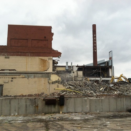
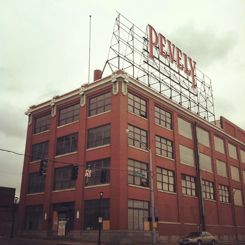
At the start of April, St. Louis University started demolishing the Pevely Dairy plant at Grand and Chouteau avenues. Last month, the Planning Commission overturned a series of Preservation Board decisions about applications to demolish components of the complex. The result of the Planning Commission decisions was the immediate approval of demolition of every part of the plant save the landmark corner office building, which can be demolished once the university secures a building permit for its new ambulatory care center.
Upon completion of demolition, the only building to remain at one of south city’s busiest intersections will be the esteemed work of Nautical Revival architecture, the Captain D’s franchise at the northwest corner of the intersection. Urbanists who proclaimed that removal of the Pevely plant would rob the intersection of urban character stand in the wrong.
Let us not forget to thank the Planning Commission’s members for wise and world-class judgment.
It’s a good thing that we have the myth of a “Team Four Plan,” because that allows us to ignore the convergence of neglectful property owners, ineffective aldermen, minimal city planning oversight and new-development-obsessed community development corporations that are more responsible for the depletion of north St. Louis than consultants who prepared a memorandum nearly forty years ago. A close read of that document does not yield the phrase “College Hill” even once, so the blame for that neighborhood’s despair lies elsewhere.
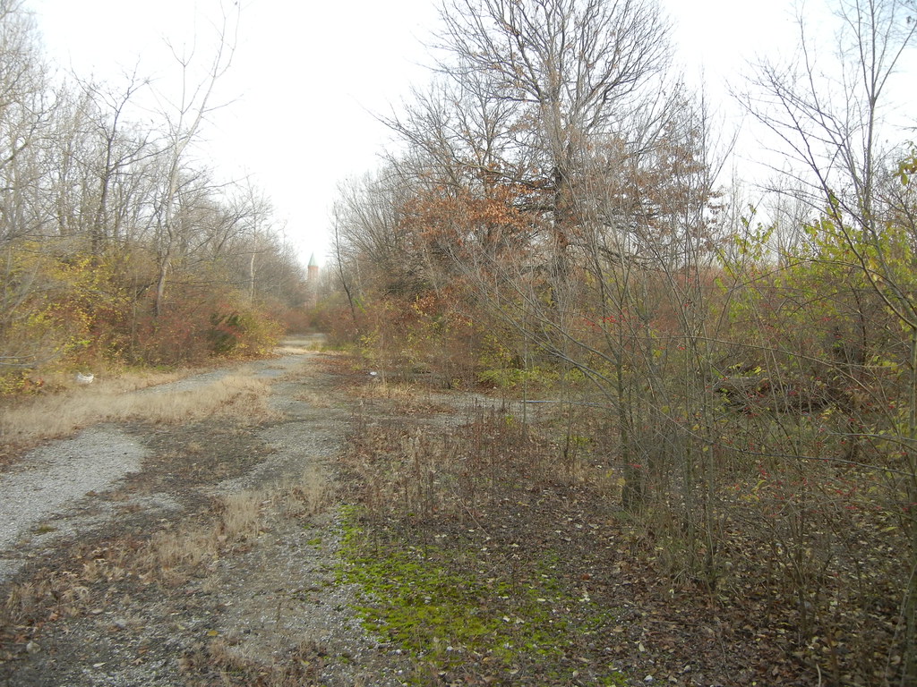
The blame for the impending demolition of the privately-owned one-part commercial block at 3773-3783 West Florissant Avenue, at the intersection of Prairie Avenue, can at least partially be laid upon recent rains that besieged a weak parapet wall that has now fallen into the building. Yet the rains are not why the building has been listed as a vacant building since 1990, and when the waters pour upon a vacant lot for the next few decades we will have to trace the demise of commercial life at the intersection further back than 2012.
Open/Closed: exploring vacant property in St. Louis (April 18-23) will kick off with an exclusive sneak peek of the documentary film Spanish Lake. The screening will offer extended clips of the film in progress and will open the Shuttered Film Fest, a series of films focused on issues related to vacancy and urban change. Spanish Lake native and director Phillip Andrew Morton and producer Matt Jordan Smith will attend and lead an open discussion following the screening. Shuttered will feature four films and Open/Closed will present five days of panel discussions and presentations. Additional details to be released. Visit Open/Closed 2011 to review last year’s event.
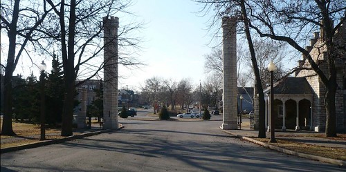
Looking west through Tower Grove Park's Kingshighway entrance, which aligns with Reber Place.
On March 12, the National Park Service placed the Reber Place Historic District in the National Register of Historic Places. Lynn Josse and Michael R. Allen of Preservation Research Office prepared the nomination for the new historic district, located just west of Tower Grove Park. The Southwest Garden Neighborhood Association commissioned the nomination using funding provided by Alderman Steve Conway (D-8th). The project also includes a nomination of a second area in the Southwest Garden neighborhood west and north of the Missouri Botanical Garden. That area is nominated as the Shaw’s Garden Historic District, and final listing is pending.
Reber Place reflects both the ambitious aspirations of its founders and a series later development patterns based on streetcar access, the presence of industry, and the rise of the builder-developer as a key force in the landscape of middle-class St. Louis. This six-block area, tightly confined between Tower Grove Park and the Oak Hill and Carondelet Railroad, has significant associations with patterns of residential planning usually seen in the successful private places of St. Louis, with rail-oriented suburban development, and with later typical patterns associated with the rise of the builder-developer and the streetcar grid.
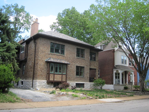
Houses in the 4900 block of Odell Avenue.Washington University architecture professor Austin Fitch designed his family's residence at 4943 Reber Place (1930).
Development began in 1885, when the first contributing feature (Reber Place’s defining central median) was created, and ends in 1957, when the neighborhood’s major institution, Holy Innocents Parish, completed its building program. With the exception of commercial intrusions and parking lots at the northeast and southeast lots of the district, Reber Place is exceptionally intact.
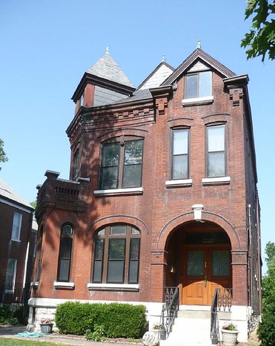
The house at 2721 S. Kingshighway, built in 1889 by F.C. Mueller & Bro.
Margaret Reber platted Reber Place in 1885 on two tracts of land that she had owned with her husband, Judge Samuel Reber. Judge Reber was known in St. Louis as a circuit court judge of good judgment and mild temper. He wrote the well-known (and controversial) majority opinion upholding Missouri’s anti-Confederate test oath at about the same time the United States Supreme Court was striking it down.” Judge Reber died in 1879.
On February 3, the Building Division issued a demolition permit to Transformation Christian Church and Outreach Center for the house at 4205 Page Boulevard in the Vandeventer neighborhood. No doubt the church needs the land for a noble purpose. No doubt also that the house was in good condition at demolition. And no doubt at all that one less house in Vandeventer is one less family in north St. Louis. Buildings fall, people scatter.
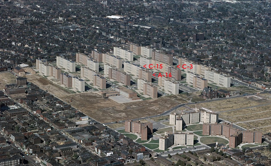
Forty years ago today, demolition work started at the conjoined Pruitt and Igoe housing projects. On March 16, 1972, the St. Louis Housing Authority took down half of building A-16 in the Pruitt side of the project through an explosive blast. This was followed by a larger blast that took down all of double-module tower C-15 on April 21, 1972. These two spectacular demolition events led to the ultimate decision to demolish all of Pruitt-Igoe’s remaining 31 towers in 1976 and 1977. Yet on March 16, 1972, the St. Louis Housing Authority was not attempting to kill modernism, high-rise public housing or even Pruitt-Igoe. Instead, the Authority was trying to save these things.
In early 1972, the St. Louis Housing Authority created a task force of local and Department of Housing and Urban Development officials to examine physical interventions that might alleviate the problems at Pruitt-Igoe. The biggest challenge then was vast oversupply of housing units. Fewer than 400 of the over 2,800 units in the 33 towers was occupied. The St. Louis Housing Authority was faced with a need to reduce the unit count and eliminate vacant buildings in order to improve conditions for occupied buildings. Yet the fractional rent collection on the complex made solutions difficult to finance.
The locations of the three towers slated for blast, amrked on a 1959 U.S. Geological Survey photograph of the Pruitt and Igoe projects.
The task force elected to explore reducing the towers’ heights to four stories — a somewhat ironic move given that early plans had called for a low-rise development. The 1947 city Comprehensive Plan had advocated low-rise garden apartments on the site, and architect Minoru Yamasaki’s first concept for the project consisted of four and six story buildings. The St. Louis Housing Authority, under the leadership of Director Thomas Costello, elected to experiment with reducing floor heights.
However, recognizing the surplus of buildings and the need for experimentation, Costello successfully sought HUD permission to demolish three buildings in the project. These demolitions would allow for experimentation in demolition techniques to assess value engineering of the floor removal, and they also would allow the Authority to create a park in the center of the project. At one point, the Authority even explored retaining the rubble from the wrecked buildings as a sort of bizarre landscape feature.
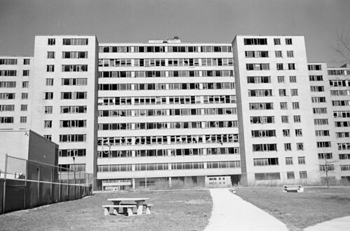
The south face of a vacant single-module tower at Pruitt-Igoe. (Source: State Historical Society of Missouri.)
On the morning of March 16, 1972, Costello obtained a building permit for demolition of three towers, to be taken down by explosive blast. The St. Louis Housing Authority selected three towers at the center of the project, along Dickson Street (the only east-west public thoroughfare on the site, and the dividing line between the Pruitt and Igoe projects). The Authority chose towers A-16 and C-15 south of Dickson, and tower C-3 north of Dickson. C-3 would never be demolished by blast. The towers chosen included one of the 180-foot-wide single module towers, A-16, and two 360-foot-wide double module towers, C-3 and C-15. The Authority estimated the cost of demolishing the three towers at $12,000. Over $35 million in bonded construction debt was still owed on Pruitt and Igoe.
The St. Louis Housing Authority hired Dore Wrecking Company of Kawkawlin, Michigan, to conduct the demolition. St. Louis wreckers had never worked with large-scale explosives. Dore Wrecking in turn subcontracted the explosive work to a colorful firm in Towson, Maryland, named Controlled Demolition, Inc. Jack Loizeaux founded Controlled Demolition in 1947, and the company had experience using explosive methods to take down many buildings around Baltimore. The well-publicized Pruitt-Igoe blasts would make the company famous. Controlled Demolition would become the nation’s top firm for explosive demolition, and its future projects would include the Hudson’s Department Store in Detroit, the Kingdome in Seattle, and parts of Yamasaki’s World Trade Center in New York.
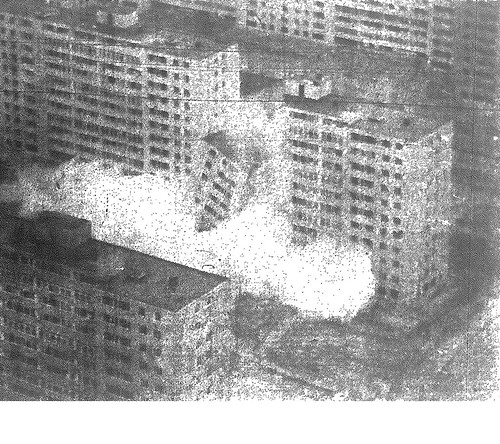
Building A-16 collapsing on March 16, 1972.
For A-16, Controlled Demolition planned to take down only half of the tower by blast. There was electrical equipment in the basement that the St. Louis Housing Authority wished to protect, so the other half would be taken down by crane and wrecking ball. Controlled Demolition placed specially-designed dynamite sticks into holes drilled in the building’s concrete upright columns. The detonation would start at the base of the building, to weaken its support, and travel upward.
On March 16, the demolition event was set for 1:30 p.m. At that time, officials postponed it to 2:15 p.m. That time arrived, and wreckers realized that the blast machine had accidentally went along for a pick-up ride to Lambert International Airport. John D. Loizeaux, president of Controlled Demolition, professed embarrassment at the less than punctual start of demolition. Yet the delays allowed for the blast to start after 3:00 p.m., when Pruitt School sent its elementary students home for the day. The students flocked to the demolition site.
Looking east down Dickson Street in December 2011. The sites of A-16 and C-15 are at right, while the site of C-3 is at left.
The blasts were heard as muffled gunshot-like sounds, and rather than send out a distress call, they were almost easy to miss. Upon the end of the blasts, the west half of A-16 collapsed in a rising clod of debris. Notable was that the building had lead paint used inside, and there had been no abatement. The slabs pancaked into a pile that would require hand wrecking to remove. Building A-16 was only 17 years old upon demolition, and its reinforced concrete structure was resistant to blast.
At the end of demolition, officials were confident in the methods of Controlled Demolition, and scheduled the second and more spectacular blast for April 21. Yet Thomas Costello told the St. Louis Post-Dispatch, “[t]his is only the first step, and there are many more to go. We don’t know what they will be at this time.” Pruitt-Igoe was not dead yet.
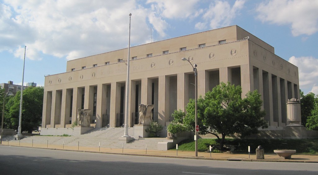
The Soldiers’ Memorial was completed in 1938 as the centerpiece of Memorial Plaza, a municipal landscape devoted to St. Louisans who sacrificed their lives in World War I. Designed by Mauran, Russell & Crowell with Preston J. Bradshaw, the building offers an angular, modernist reduction of a classical Greek temple form. This building and its military museum anchor a historic civic landscape, but public awareness and financial stability have been elusive in recent years.
Now the National Park Service is studying acquiring the Soldiers’ Memorial, which the City of St. Louis has owned since construction. Should the city convey a public building long maintained by local taxpayers to the federal government? Will the National Park Service be able to increase attendance and improve the curatorial practices of the museum? These questions are now on the table.
Thursday, members of the public will have the chance to offer comments on the National Park Service study of acquisition and management of the Soldiers’ Memorial. The following is taken from an announcement posted this week by Ruth Heikkinen, Project Manager, Soldiers’ Memorial Military Museum Special Resource Study:
The National Park Service was directed by Congress in Public Law 110-229 to evaluate the Soldiers’ Memorial as a potential unit of the national park system. For a site to be recommended as a potential new park unit, it must meet the criteria for national significance, be a suitable and feasible addition to the park system, and NPS must be found to be the best option for management. Studies that evaluate these criteria are called special resource studies (SRS).
Public input is an important part the of the SRS process, and we invite your attendance at our public meeting at the Memorial on March 15th from 5-6:30pm (see Meeting Notices at left for more details). We also invite your comments on the Draft SRS (to be posted by March 14th, 2012 …).
We are in the final stretch of the process of securing historic district status for most of the O’Fallon neighborhood. By early May, Preservation Research Office will have submitted the first of two National Register of Historic Places nominations that cover almost all of the historic neighborhood. The O’Fallon Park Historic District will encompass the areas east and south of O’Fallon Park, while the Fairground Park Historic District will encompass an area west of Fairgrounds Park south of Lee Avenue, north of Natural Bridge Avenue, west of Fair Avenue and east of Newstead Avenue.
The historic district designations are sponsored by the Acts Partnership with the assistance of Alderman Antonio D. French (D-21st). Work began last February on a 1,796-building survey that had led to the two historic district nominations currently being drafted.
The decision to split the neighborhood is based on subdivision history and development patterns. The area of O’Fallon west of Fairgrounds Park was first developed after the platting of White Place in 1859, but construction was slow. Additional subdivisions were Mary E. Burson’s Subdivision (1889), Fairground Place (1910), Lucille’s Fairground Park Addition (1912) and several others. Most of the building stock there dates to between 1910 and 1940, somewhat later than the northern part of O’Fallon that started development in the 1890s and largely built out by 1930. Like the northern part of the neighborhood, the area is remarkably intact. Here are a few photographs.
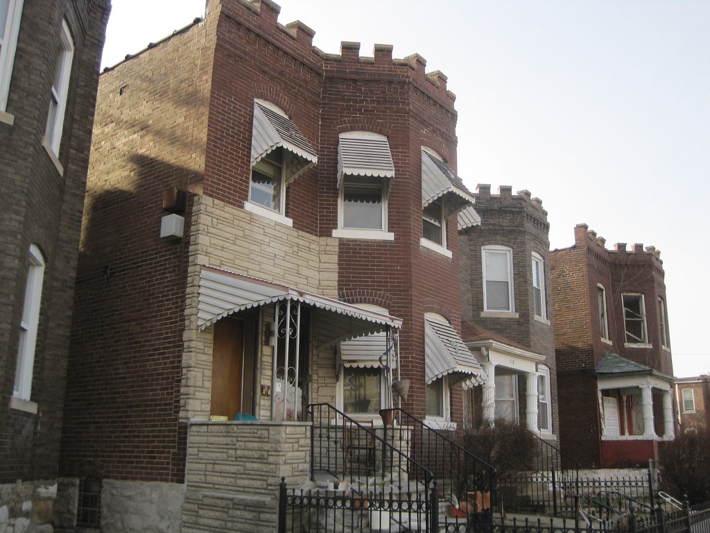
There is a row of castellated two-flats on the east side of the 4100 block of Harris Avenue.The 4100 block of Kossuth Avenue is on the north side of Fairgrounds Park.