Categories
Brick Theft Demolition North St. Louis Northside Regeneration St. Louis Place

Cut Off

by Michael R. Allen

Shown here is the house at 2569 Montgomery Street in St. Louis Place before its demise at the hands of brick thieves earlier this year. When I took this photograph in February, thieves had already taken down much of the western wall of the house, causing interior collapses. Not long after I took this photograph, a brick wall collapsed on some thieves working on this house and, in the ensuing attempt to dig out one of the wreckers, police arrived on the scene to ticket the “crew” with trespassing. At least, that’s the word on the street — court records don’t turn up anything.

The false-mansard-faced two-story house was built in 1888, long before Parnell Avenue to its east was widened out of proportion with demands. This house stood on a block orphaned between the needless expanse of Parnell — a formidable pedestrian boundary — and the expansion of industries to the west that involved major street closures. The life-flow of cities and blood alike is circulation. Any part cut off from circulation eventually dies. This house ended up in the possession of Blairmont Associates in 2005. No surprise that the owners of the house next door sold to Blairmont sister company Sheridan Place in 2006.

Categories
Demolition North St. Louis Northside Regeneration St. Louis Place

Another Lost Chance

by Michael R. Allen

In “Daily Dose of Blairmont #12” back in March 2008 (the daily series is now up to #137), Built St. Louis author Rob Powers presented the graceful mansard-roofed four-flat at 2341 University Street in St. Louis Place. Powers’ chronicle of historic buildings in north St. Louis owned by developer Paul J. McKee Jr.’s holding companies shows us both solitary survivors and houses that contribute to groups of historic houses. This building was one of the latter — while the block face across the street is gone, the north side of the 2300 block on University is fairly intact toward its west side.

In his blog post, Powers asked the question: “Will this row, like so much around it, become nothing more than a memory, leaving no trace of what this neighborhood once was?”

Sadly, the answer has come: Yes.


On June 9, the city’s Building Division issued an emergency demolition permit for the building. Unlike many other McKee-owned buildings on the near north side, this house was protected by occupied neighboring houses. The brick thieves never arrived to carve up the fine house. Although vacant and deteriorating since at least 1989, the house was in pretty fair shape as vacant north side buildings go. The house was pretty rough when McKee’s Blairmont Associates LC purchased the house from Ruth Erbschloe in 2006, but not unsound under reasonable interpretation of city code. An emergency order seems rash, even from the perspective that the house needed wrecking.

Then again, we don’t have means for making very careful choices about houses like this one. The 5th and 19th wards, where McKee’s holdings mostly lie, lack preservation review for demolition. Even without the questionable emergency order — not the first in this neighborhood for a building that seemed sound under city ordinances — there would have been little to stop this demolition, save the owner. The owner, of course, has made no plans clear. With no comprehensive plan for land use and preservation coming from either the city or McKee, much of St. Louis Place and JeffVanderLou stand in a torpor — except that which will no longer stands. Add the house at 2341 University to the list.


What a shame this loss truly is. As Powers notes, that block is pretty solid architecturally. The house immediately to the east is obviously well-tended, retaining many original architectural features including its iron fence. Obviously, that house should be an anchor for spreading redevelopment on a block still residential in character. There are plenty of blocks in St. Louis Place where one can find large expanses for new construction. Those retaining historic residential fabric and homeowners need a careful approach we’re not likely to get without a public planning process. The real “emergency” is the lack of coordination between city government, McKee and stakeholders in St. Louis Place and JeffVanderLou.

Categories
Demolition Industrial Buildings North St. Louis

Vanishing Bakery

Currently under demolition, an old bakery complex stands at the northwest corner of Cook and Sarah avenues inthe Vandeventer neighborhood. While not as large or as architecturally refined as some of the larger bakeries of the city, the complex here typifies the smaller bakeries that were opnce sources of neighborhood employment across the city’s working-class neighborhoods.

While growing into a complex of at least four different sections, this complex had its start as a small neighborhood bakery operated out of the two-story brown brick corner building. The permit for the corner building dates to January 6, 1904, when baker F.J. Schneider (who resided nearby at 1115 S. Sarah) took out a permit for a $13,000 facility. The bakery may have been small, but that cost is not insignificant. H.F. Holke (office at 2583 Wrne Avenue) served as contractor and little-known Otto Bachner (office in the Wainwright Building) was architect. These names indicate the extent of German settlement in this part of north St. Louis.

Schneider continued to expand his operation, adding oven in 1905. The operation was called, oddly enough, the “French Bakery.” In 1909, Schneider built a two-story stable on the alley side, hiring A.H. Haesseler as architect. The 1909 Sanborn fire insurance map captures this point in the bakery’s history:


Here we see the bakery building at the corner, showing the first floor partitions and the three bake ovens then in place. This map shows that the block was essentially a residential block, with houses just a few hundred feet from the hot, pungent world of the bakers. However, just west of the bakery the map shows a “bottle works” operating along the alley behind a house. (That building was later incorporated into the bakery.) This mix of uses was not uncommon in the early 20th century even in well-kept neighborhoods west of Grand Avenue. Our ancestors were doing the “live-work” lifestyle long before it got any coverage in Dwell.

In 1910, Schneider again expanded, taking out a $19,000 permit for “alterations to a second-class bakery.” Hartmann Building and Construction Company served as contractor. Additional permits from 1918 show installation of four more ovens and significant alterations. By 1919, the bakery was owned by Nafziger Baking Company. That company continued to expand the facility, and on February 18, 1928 took out a $42,000 permit to build a two-story addition to the west of the 1904 building, most of which is missing in my photographs. This particular bakery ended its baking days as the Taystee Bakery, operated by the American Bakeries Company.


The robust concrete-framed inudtrial buildings showed few signs of deterioration when owner Transformation Christian Church took out a permit this year for demolition. Located in the 19th Ward, which is not covered by the city’s opt-out preservation review laws, the demolition was never reviewed by the Cultural Resources Office.

Categories
Demolition Historic Preservation North St. Louis Northside Regeneration St. Louis Place

Another Lost Corner in St. Louis Place

by Michael R. Allen

In March, I wrote about the tragic loss of an entire block of buildings in St. Louis Place due to brick rustling. Many of the houses on the 1900 block of Wright Street between Florissant Avenue and North 20th Street were owned by Paul J. McKee, Jr., but three were owned by others. (See “Brick Rustlers Decimate Wright Street Block,” March 26, 2008.) Two buildings comprising a magnificent row had been the property of DHP Investments, the failed company led by Doug Hartmann that left over 120 historic city buildings in various states of abandonment, including the landmark Nord St. Louis Turnverein. Hartmann’s buildings here were imposing three-story buildings with elegant masonry details, mansard roofs punctuated by squared dormers and even intact cast iron balconies.

Missing from my earlier coverages was mention of a row that stood across the alley on Dodier Street until this February. The two buildings at 1944-50 Dodier Street were not as exotic as their neighbors to the south, but they were every much as responsible for creating the sense of place for the neighborhood. The best part of these two buildings was their relationship: the eastern tenement building was wide and set back from the street, while its conjoined neighbor with commercial space came right up to the sidewalks on both Dodier and 20th streets. This pair beautifully demonstrated the order or urban space as it recedes from the public sphere to the semi-private. Here, the public was that which is immediate to the right-of-way, while the semi-private was removed just enough to mark the boundary between residents and passers-by. Both buildings were completely urban.

The details were also lovely. The tenement’s brick dormers pack a punch not found in the small belt courses and elegant but typical stone sills. Next door, a corbelled cornice, central dormer and vivid stone keystones give a plain brick wall pizazz. The details are common for vernacular buildings of the 1880s and 1890s, when these were built. While the rarity of such buildings and their details makes them more precious, their historic commonality provides the real significance. There was a time when such finesse was a matter of course even in working class housing.

Alas, these buildings fell into the hands of the city’s Land Reutilization Authority by the 1970s, and were vacant for awhile before Victor Casine (whose ownership of another building recently was profiled in the Vital Voice) purchased them in 1982. Casine promised rehabilitation, but did little other than allow further deterioration. The city’s Building Division reported the buildings as vacant for every year that Casine owned them. Numerous citations led to one suit filed by the city against Casine. Casine himself sued the city in 1989 for supposedly damaging the property when the Forestry Division mowed the overgrowth Casine did not trim himself.

After three years in which Casine did not pay outstanding liens and taxes on the property, the Sheriff auctioned the houses in 2003. This time was on the cusp of McKee’s purchasing, and so the buildings found no bidder. The Land Reutilization Authority took title once more, and after the rear walls collapsed was granted emergency demolition by the Building Division in January 2008. And so it goes. Those new to following land speculation and demolition in St. Louis Place should know that the tragedy is not new and has never been closer to real solutions as it is now. A long time ago, buildings bit the dust without so much as a photograph taken and owners let property decay without a call to the alderman, let alone protests at City Hall. Now, there is relatively wide attention on the future of the neighborhood. From that attention could come action.

Categories
Demolition Historic Preservation LCRA Riverfront

Casino Claims Historic North Riverfront Warehouses

by Michael R. Allen


Nestled between two prominent landmarks, the glitzy new Lumiere Place casino complex and the venerable Ashley Street Power House, stands a group of warehouse buildings. These aren’t the most iconic buildings — certainly not amid such strong competition. Still, the street wall presence of three buildings on Leonor K. Sullivan Drive between Carr and Biddle ties together disparate sections of riverfront fabric.

That presence is about to disappear. In May, the city’s Preservation Board voted 3 to 2, approving demolition of the buildings. While the applicant was the city government, Lumiere Place owner Pinnacle Casinos was a forceful advocate for razing the historic warehouses.

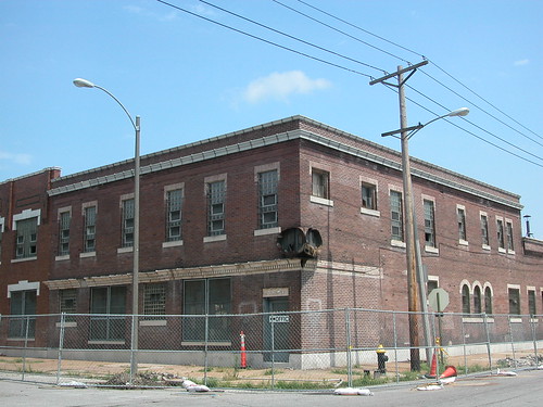
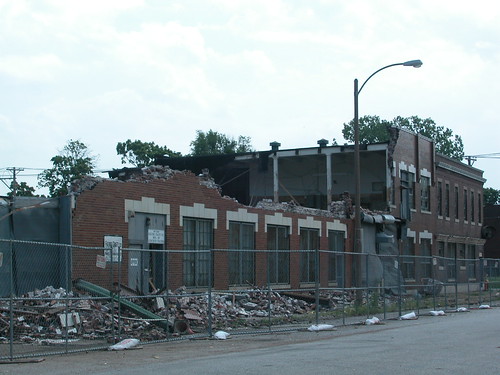
The warehouses in question comprise a wide four-story brick building built in 1881, a modern addition to the south from 1946 and a long one-story stone building to the north built in 1883. The grouping is a little peculiar, but there’s a reason for the strange appearance.

Thomas McPheeters was on his way to becoming one of the West’s biggest storage magnates when he built the four-story center building in 1881. That building was used for warehousing dry goods, and its looks are not out of the ordinary for industrial St. Louis. Yet its northern neighbor is an odd one-story stone-faced building built by McPheeters in 1883. Early fire insurance maps state that this building was lined with cast iron, suggesting that this was a primitive cold storage warehouse. McPheeters continued to develop cold storage facilities, and in 1900 and 1901 built much larger brick cold storage warehouses a few blocks north of his earlier building. Eventually McPheeters’ company sold the earlier buildings to the Thompson Chemical Company, which added the south building in 1946 and used the buildings for production.

Concerning the immediate surroundings, many remaining buildings were wrecked for Lumiere Place but an impressive pocket to the north contains large buildings, including the Ashley Street and Laclede power houses and McPheeters’ later buildings. These buildings comprise the North Riverfront Historic District National Register of Historic Places, listed in 2002 in response to renewed interest in developing the area.

Unfortunately, the old McPheeters buildings were not able to be included because a 2001 fire (and demolition) at the old Belcher Sugar Refinery left the old McPheeters buildings too far from the district to qualify. Yet the buildings could still be listed on the National Register of Historic Places, making historic rehabilitation tax credits available.

Unfortunately, that prospect will not come. The city’s Land Clearance for Redevelopment Authority (LCRA) purchased the buildings in 2003. LCRA’s name says it all – the agency exists to clear land for new projects like Lumiere Place. However, the original Lumiere Place redevelopment plan didn’t include the fine old warehouses, leaving open the possibility of reuse.

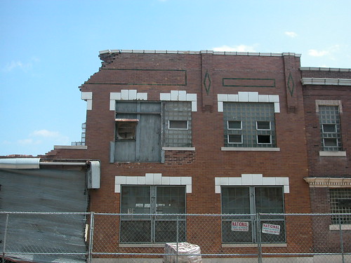
All three buildings are sound, and the city’s Cultural Resources Office has advised that none have conditions of unsoundness established under the city’s preservation review ordinance. Still, there are challenges here — but none even as big as building a multi-million dollar, state-of-the-art casino. The middle warehouse has lost a section of one wall, exposing part of the wooden post and beam structure. The roof is missing in places. These are the conditions one expects for vacant property of this age, and conditions that have become standard fare for St. Louis tax-credit-savvy developers.

Although I cannot profess much respect for the execution of the Lumiere Place architecture and site plan, I was hopeful that its presence would not be a huge intrusion into the historic fabric of our riverfront. While the casino is visually at odds with surrounding architecture, and its construction entailed demolition of historic fabric, its location is ideal for connecting Laclede’s Landing to the industrial buildings to the north. Pinnacle repeatedly discusses a second phase of Lumiere Place that will create much-needed housing on the riverfront.

Pinnacle could have made as bold of a move as it did with its new casino and included historic rehabilitation in its plans. Connecting the new development with the historic context would be cool and smart, demonstrating Pinnacle’s commitment to transcending the usual. Also, utilizing historic rehabilitation tax credit and unusual buildings would offer additional financing tools and create something more special than a new building. The bonus would be the impact of helping to draw development up into the North Riverfront Historic District.

Pinnacle and city development officials have touted Lumiere Place as a catalyst for spreading investment across the riverfront areas north of the Eads Bridge. The vision of a vibrant riverfront with residential space certainly is compelling. Then, at the Preservation Board we heard from St. Louis Development Corporation Deputy Director Otis Williams, who told us that Lumiere Place wanted the McPheeters warehouses torn down because their appearance was supposedly hurting casino revenue. There’s a mighty large gap between the promises of spreading investment and the self-contained concerns conveyed through Williams.

That’s a gap big enough to swallow three fine buildings, but hopefully not the larger vision of revitalizing this section of riverfront by sensitively connecting the fabric of Laclede’s Landing and the North Riverfront Historic District.

This article first appeared in the Vital Voice on June 13, 2008.
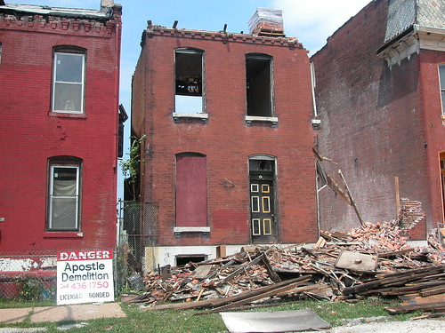
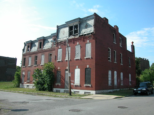
Categories
Abandonment Demolition Flounder House Historic Preservation North St. Louis St. Louis Place

Two Blocks of Florissant Avenue in 1985

by Michael R. Allen

While demolition permit numbers show that the peak decade for material building loss in the Old North St. Louis and St. Louis Place neighborhoods was 1970-1980, a substantial slower loss has transpired since then. The cumulative result is that streetscapes recognizable as urban places twenty-five years ago now form desolate landscapes lacking architectural definition.

Two photographs of the west side of Florissant Avenue in 1985 taken by Mary M. Stiritz for Landmarks Association of St. Louis depict the absurd reality that in the near past, the eastern edge of St. Louis Place was marked by the familiar nineteenth century vernacular masonry buildings that typify other sections to this day.

Nowadays, Florissant Avenue is a confused corridor notable for its many vacant lots and the needless wide expanse of roadway that awaits MetroLink expansion. This area was once a vital part of a beautiful neighborhood. In 1985, Landmarks was preparing a survey leading to expansion of the Clemens House-Columbia Brewery Historic District; sufficient physical stock existed here to allow major expansion of a national historic district. Today, further expansion remains a fantasy at best due to continued loss.

Behold the northwest corner of Warren Street and Florissant Avenue, today a sun-scorched vacant lot:

While the architectural context is visibly diminished, the important corner site is occupied by a building that becomes a landmark heralding the site as one for human comfort and exchange. As we rebuild St. Louis Place, we should ensure we have good corners, and not drive-through lanes, curb cuts and fences where the marks of human settlement should be.

The second photograph shows the block of Florissant between North Market Street on the south and Benton Street on the north:

Here was a hybrid row of commercial and residential buildings, all brick but differing somewhat on setback, height and style. There are a few side-gabled buildings, with a mansard-roofed store second in from the corner adjacent to a flounder house with a generous side gallery porch. Dormers abound. There’s even a modern Payless Shoe Store at the right of the image. This is a resolutely urban group, friendly to the pedestrian and attractive to the eye.

All of these buildings are now gone.

Categories
Demolition Historic Preservation Midtown

Locust Street Building Demolished

by Michael R. Allen


A few people have asked me about the current demolition of a building at 3126 Locust Street in the Locust Business District just east of Compton Avenue.

The building being demolished unfortunately could not be included in a recent Locust Street Automobile Row Historic District extension due to heavy alterations. While remaining sections of the building show a Spanish Revival facade of stucco and brick, the building was clad in metal paneling until very recently. The installation of the panels damaged the facade, and the owner — Scott Pohlman, who developed the residential building next door to the east — elected to demolish the building and build a new residential structure on the site.

In 1888, this was the site of the new First Christian Church building. The present building sections date to 1913 and 1919. A 1919 city directory shows Gill Piston Ring Company and Standard Roller Bearing as tenants. The tenant listing is not surprising; “Automobile Row” on Locus included perhaps more parts manufacturers and distributors than automobile dealers and distributors. Companies like these made St. Louis the “Second Detroit” (almost first).

While 3126 Locust may have been salvaged, and I think it could have been, at least there is a redevelopment plan leading to a beneficial trade-off. There have been too many parking lots added in recent years, especially by St. Louis University — which makes no secret that parking, not development, is its end goal.

Categories
DALATC Demolition North St. Louis Northside Regeneration Old North

Old North Building Owned by McKee Demolished

by Michael R. Allen

The house at 1412 Sullivan Avenue in Old North St. Louis fell to wreckers last month. The building was already badly deteriorated when Paul McKee’s holding company Babcock Resources LLC purchased the property at a sheriff’s sale in October 2007. (See “McKee Purchases Building on Stable Block in Old North”, October 25, 2007.)

Complaints from some neighbors over bricks falling from the parapet wall led to Building Division action. No, not stabilization or a nuisance property suit, but “emergency” demolition, via an order issued on April 16 by Demolition Supervisor Sheila Livers.

The 1400 block of Sullivan Avenue has only seen one demolition since the start of the twentieth century. The block of Hebert Street to the north has seen none (although it has three McKee-owned buildings on it now), making it the only fully intact block in Old North. Still, this block of Sullivan came in closely behind, with a strong sense of historic character and committed residents.

Obviously, McKee cannot tear down the rest of the block. Mayor Francis Slay would be crazy to approve eminent domain use in Old North, where he has attended several house fundraisers for his campaigns. McKee’s interest in this property stems from its ability to help him qualify for acreage requirements under the Distressed Areas Land Assemblage Tax Credit as well as to have further political leverage in Old North. The building was inconsequential to his plan — but vital to the sense of place of those who look out of their windows and now see a pile of brick bats.

Would it have hurt McKee to have put a new roof on the building and done some brick work? Those expenses would have qualified as maintenance costs under the same tax credit that covers demolition. Promises to do better with maintenance are meaningless in the face of demolition by neglect.

For residents of Old North, amid a $35 million rehabilitation project that will reopen 14th street and rebuild 28 buildings, this is a small blow. We’re on a roll. Still, that makes this loss so much more senseless.

Categories
Demolition Historic Preservation North St. Louis St. Louis Place

The House at 20th and St. Louis

by Michael R. Allen

We shall never again see this beautiful house at the northeast corner of 20th Street and St. Louis Avenue in St. Louis Place, just north of the boundary of the Clemens House-Columbia Brewery National Historic District. Wreckers took down the house last week as part of a city demolition package. The house had fallen on hard times. Vacant for years, the house lost its roof through collapse and sections of the western wall were beginning to collapse inward. Its owner was an elderly man who lived in the ruins; he was apparently on a bus downtown to try to stop the demolition when the wreckers started their work. The home was mostly gone when he returned.

Nonetheless, the beauty shone through the devastation. This was one of the few early large corner houses on St. Louis Avenue. Notice the shallow setback from St. Louis Avenue and the lack of any setback at all from 20th Street. Originally a single-family home possessing the same grandeur of its peers on the avenue, the house is resolutely urban in character. St. Louis Place had an order of fine houses, and homes on St. Louis Avenue were more prosaic than the slightly more expensive ones that lined both sides of the St. Louis Place park. Hence this house balances the expression of wealth its owners intended with a conventional placement of the home typical of the street. No one could have expected seclusion on a main thoroughfare.

What was most striking about the home was its intact features. Although derelict, the house was never painted and kept its wooden windows, the cornice, dormer, slate shingles and even its roof cresting. The eclectic mix of Second Empire and Italianate features was restrained by the purity of expression typical of its time (likely the early 1880s). The front wall was brick, the lintels simple stone arches. There was little pretense despite its stylistic impurity.

Standing vacant, the home was almost frozen in time. While the home remained immobile, the forces of water, gravity and time moved forward against the house.

Categories
Central West End Demolition Flounder House Historic Preservation North St. Louis Preservation Board South St. Louis The Ville Tower Grove East

Preservation Board Approves Flounder House Demolition, Denies Demolition in The Ville

by Michael R. Allen

Here’s a quick report of some actions at yesterday’s St. Louis Preservation Board meeting.

2915 Minnesota Avenue: Preliminary approval for demolition of flounder house granted 4-2. Terry Kennedy, Mary Johnson, David Richardson and Anthony Robinson in favor; Melanie Fathman and Mike Killeen opposed.

4477 Olive Street: Unanimously deferred until the July meeting to provide more time to explore alternatives.

4568 St. Ferdinand Avenue: Demolition permit denied 4-3. Killeen, Fathman, Robinson and Richard Callow in favor of motion to deny; Johnson, Kennedy and Richardson opposed.