Categories
Infrastructure St. Charles County St. Louis County Streets

St. Louis Area Makes a List for Obama Administration

by Michael R. Allen

An article in the December 26 edition of the St. Louis Business Journal reported that the City of St. Louis has created a 400-page report on its federal infrastructure funding priorities, while St. Louis County has created a 200-page document of the same. The governments will deliver these reports to the incoming presidential administration of Barack Obama in response to his promise to channel federal dollars into public works programs across the nation.

The city’s report outlines some big-ticket priorities: $900 million for the North/South MetroLink line, $219.5 million in streetscape improvements, $160 million in public school building improvements, $80 million in airport improvements and $59 million to implement the Gateway Mall Master Plan. According to Deputy Mayor Barbara Geisman, all of these projects are ready to start as soon as they are funded, but full funding is unlikely immediately. Still, the city’s placement of MetroLink expansion at the top of its list is smart, since that is a crucial component of building a strong city economy and connecting citizens to jobs. The city’s list carries some basic but crucial needs: street and transportation improvements and school renovation. (The Gateway Mall project is another story, but something does need to happen to the mall area.) These are important to stabilizing our neighborhoods, and Geisman should be commended for placing a high priority on these things.

Moving beyond the ready-to-go ideas, perhaps the city would consider a future request for an urban homesteading program. The program could find funding to stabilize and market the Land Reutiliation Authority’s thousands of vacant homes across the city, generating hundreds of construction jobs and getting tax-free property back on city tax rolls where it can generate money to fund roads and schools.

St. Louis County’s list starts with a $200 million, 3.3-mile expansion on Highway 141 at the top followed by the $105 million needed to retain existing Metro public transportation in the outer county. A significant and less costly item on the St. Louis County list is $24 million to fund a Midwest China Trade and Commercialization Center at NorthPark. While the China cargo hub prospect is not a done deal, it has the potential to bring more jobs to the St. Louis area in the next decade than any other prospect.

Other requests headed to the Obama administration are a predictable $510 million highway spending request from the Missouri Department of Transportation and a $66 million request to extend Page Avenue farther into St. Charles County, so that one may have a straight drive from downtown St. Louis to Mid Rivers Mall Drive. These requests are the usual pave-it-and-they-will-come junk.

Obviously, the disparate requests show the problem of regional political fragmentation. Inevitably, there will be partial funding of many requests rather than full funding of something big and transformational. Imagine what might happen if the regional governments pulled together with one request for the North/South MetroLink line this year, and further extensions in the future, rather than place the burden solely on the City of St. Louis. Imagine if the Missouri Department of Transportation put some of the needed Metro funding in its request.

Remember when we imagined that Obama could become president? Now that the dream is real, it’s time to imagine other changes closer to home. Or, we can all fight over the pie for the next eight years, but it doesn’t take much imagination to guess where that will get the St. Louis area.

Categories
Chicago Infrastructure Streets

STOP

by Michael R. Allen

This neat feature alerts drivers in an alley headed north toward Ontario Street between Linden and Euclid avenues in Oak Park, Illinois. Embedded tiles form a sturdy, enduring stop sign.

Categories
Architecture Central West End Infrastructure

Kinloch Telephone Company Delmar Exchange

by Michael R. Allen


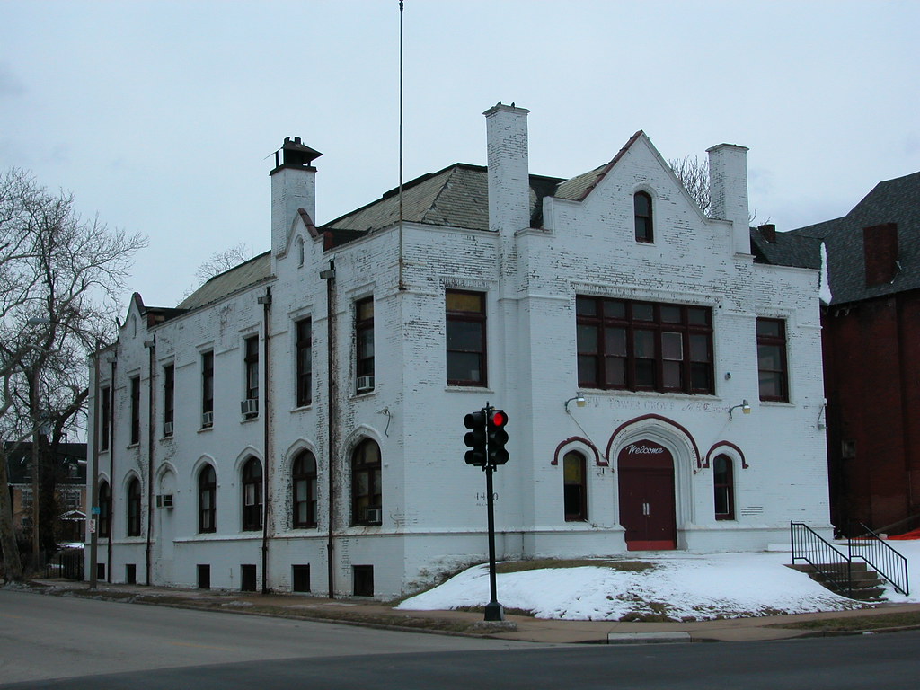
People driving down Delmar Boulevard may not known the history of the building pictured above, which is located at 4400 Delmar (southwest corner of Newstead & Delmar). With its hipped roof, almost Gothic window profiles and prominent entrance, the building may look like a church or social hall of some kind. In fact, currently the building is home to the New Tower Grove Baptist Church. Yet underneath the layer of white paint and the exotic style lies an intriguing but somewhat mundane building.

This building is the Delmar Exchange of the old Kinloch Telephone Company. At the turn of the twentieth century, St. Louis had two major telephone companies: Kinloch and Missouri Bell, which eventually secured a statewide monopoly. Kinloch served the entire city and St. Louis County; the company built four “exchanges” in the city where calls were repeated and switched to local lines. Kinloch survives as the name of a north county municipality near the airport, but little else. Kinloch’s last company headquarters stands downtown at the northwest corner of 10th and Locust streets, with its brick and terra cotta covered in a 1950s concrete skin. That building became the Farm and Home Building in the 1950s.

The architect of the repeater and switching building is Isaac Taylor, who also designed the first downtown headquarters on Seventh Street, served as chief architect of the 1904 World’s Fair and design numerous important downtown buildings. The building permit for the Delmar building dates to April 14, 1902, with the cost listed as $30,000 and Edward Steininger as contractor. A second major permit issued July 16, 1923 reports $20,000 in repairs with Southwestern Bell as the applicant and Steininger as contractor. The station had been subsumed when Bell purchased Kinloch Telephone Company earlier that year.

Categories
Downtown Infrastructure North St. Louis Streets Transportation

Time is Right for Making Changes to New Mississippi River Bridge

by Michael R. Allen

On February 28, outgoing Missouri Governor Matt Blunt announced that Illinois and Missouri had reached a final agreement for construction of the new Mississippi River Bridge. While actual construction remains a few years away, the agreement brings back to the forefront concerns about the bridge’s impact on the urban fabric of north St. Louis.

While officials long ago shelved a highly destructive initial bridge concept that included a local traffic connector from the bridge to 14th street, the current plan leaves much to be desired. There are many problems

Clearance. The bridge plan still entails clearance of historic buildings and existing business. While the path of the bridge itself is actually one of the least invasive paths possible, the affiliated roadway projects will entail demolition of dozens of buildings. Particularly troubling is the plan to wipe out all of the buildings remaining on the east side of 10th Street north of Hempstead Street. There are many occupied buildings and houses in that stretch. Most important, the part of Old North St. Louis east of I-70 is integral to connecting Old North to the emerging North Broadway corridor.

Bridge planners are more concerned with traffic efficiency than creating infrastructure that respects settlement patterns. While I-70 has some maddening issues related to placing exit ramps in odd spots due to existing buildings, those issues are small concessions to reality. Reality is that cities are what bind people together, and highways are but a means to that bind. Reconfiguring the St. Louis Avenue interchange is economically profligate; the plan entails spending millions on a road project with no economic return. Reconnecting Old North and North Broadway will cost less and maintain an existing building stock with the potential for high real estate values.

A corollary is that the presence of highway noise and pollution lowers real estate values. Why on earth political leaders would want to champion anything that lowers real estate values amid a recession is beyond my comprehension.

Connectivity. The plan still entails closure of north-south streets like 10th Street. Northside residents use these streets to get downtown. Closing the connections will stall pedestrians and add time to drivers’ commutes. Closing the connections could isolate Old North from downtown. There is natural synergy between Old North and downtown, but there are physical impediments caused by a belt of vacant land, industrial uses and monolithic public housing complexes. The bridge exploits that belt, and tightens it.

Short-Sightedness. The new bridge does not address the terrible congestion caused by the poor configuration of ramps on the Poplar Street Bridge. Would the bridge even be needed if the Poplar Street’s problems were fixed? No.

The bridge plan does not include any allowance for public transit. There is no space on the bridge for a street car line. That’s going to seem silly in 25 years when our automobile lifestyle will be in crisis. Oh, well — at least we can still walk across the bridge then.

Avoidance. The bridge path funnels I-70 traffic out of East St. Louis and away from downtown St. Louis. This path is a boon to people wanting to live in far-off Illinois suburbs like Highland but work in St. Louis or St. Charles counties. Sure, long-distance traffic will be well-served by a new bridge, but so will exurb-to-exurb commuters.

The bridge itself seems every bit a done deal. But are the details cast in concrete? No. There is still space to mitigate the bridge’s impact on the urban fabric of the near north side. Since almost every change for the better involves reducing the project cost, changes are not only logical but prudent. In the wake of the agreement, it’s time to make the best of the bridge.

Categories
Infrastructure North St. Louis South St. Louis Streets Transportation

Hemmed In

by Michael R. Allen

A resident of north St. Louis is heading south to see a friend. He drives south on Florissant Avenue but then remembers that the section of Florissant/13th/Tucker over the old Illinois Termianl Railroad tunnel is closed indefinitely. So he makes a left turn on Cass Avenue, figuring that he can useBroadway to head south and bypass downtown. oops! The bridge over I-70 is closed indefinitely. So he turns around, heads west on Cass and then south on Jefferson. That is fine until he passes I-64. Jefferson is closed.

In the kind of city where north-south connectivity is easy, this driver would not be having so much trouble. But in a city with fewer than a half-dozen north-south streets that actually connect downtown to the city south of it, he’s in a bind due to some coincidental road repairs.

There is definitely a spatial dimension to our city’s polarization between north and south. I sure hope that Richard Baron is thinking about this fact as he contemplates Chouteau Lake.

Categories
Infrastructure Metro East Transportation

East Side Sprawl Connector Stalled

by Michael R. Allen

Gateway Connector Lacks Funding – Nicholas J.C. Pistor (St. Louis Post-Dispatch, October 8)

Apparently, the State of Illinois lacks funding for a $500 million east side highway that would connect Troy and Columbia. Plans aren’t dead, though — and that’s a bad thing for the character of the small towns in Illinois that it would “connect.”

Proponents of the connector call it a boon to the growing cities of the metro east. Careful scrutiny might show that the cities are losing investment and residents in their core areas while using annexation of placeless sprawl to offset the losses. The road would reward and subsidize an a trend that is slowly killing the small urban areas of the metro east.

Categories
Downtown Infrastructure

Sidewalk Indecision at the Ninth Street Garage

A new game downtown is taking bets on how many times workers on the Ninth Street Garage will tear out and rebuild the sidewalks around the new parking garage. Today crews were seen repaving already-paved sections of the sidewalk on Locust Street along the north elevation. In recent weeks, the crews went through many changes on the Ninth Street side that involved installing a thin strip of granite since buried under a sheen of dust that renders it nearly invisible.

Needless to say, the sidewalks around the garage do not include street trees.

Categories
Downtown Infrastructure Streets

How About a Big Plan for Downtown Circulation?

by Michael R. Allen

I certainly don’t disagree that the Gateway Mall needs massive reconfiguration. I’m not opposed to drawing more people to the riverfront. I definitely would like to see a better connection between downtown and the Gateway Arch grounds.

However, as someone who uses downtown as a pedestrian up to seven days a week, I can’t say that any of those concerns is high on my mind as I walk around. One of my biggest concerns is the traffic flow. With the traffic lights not synchronized, the flow of traffic downtown is ragged — especially east of Tucker. This creates a somewhat unpredictable environment for pedestrians, and annoyances for drivers. Perhaps the Gateway Foundation or another civic-minded group would like to underwrite a study on synchronizing downtown traffic lights.

Another concern is the prevalence of loading zones and no-parking zones. On some streets, like almost all of Locust east of 9th Street and Washington east of 10th Street, there is no on-street parking at all. No surprise that few street-level uses are found on these stretches, and that pedestrians avoid these speedways. On-street parking would help businesses, slow traffic and create a more welcoming pedestrian environment.

Also of concern is the growing number of signs, benches, outdoor dining areas and other obstructions that impede the public right-of-way. While not devastating, this problem creates hostile spots for pedestrians, who aren’t always equally able-bodied. I welcome outdoor dining, but hope that the city thinks circulation on public sidewalks is a higher priority.

Then there are street and alley closures and cut-offs that force people into unnatural travel patterns. Sadly, the Gateway Mall Master Plan actually recommends new street closures. Such closures are the worst thing that could happen downtown right now. Streets are the mechanisms of urban exchange; they create economic opportunities for developers and merchants. More streets are always a good thing for a downtown.

Sidewalks and streets are our rights as citizens of a city. They create the means of traversing the city, moving people as well as goods. The success of downtown hinges on the usability of its streets and sidewalks, which deliver people to the buildings where they live, work or spend money. Big plans for the downtown area need to examine circulation issues. In fact, I would argue that the circulation issues are far more pivotal than the supposed lack of destinations fueling the Gateway Mall and riverfront plans. I think that many of the problems with people not going to certain parts of downtown is more due to poorly-functioning streets as well as a lack of places to live, work and shop (read: functional urban buildings). Fixing some of these problems will yield bigger results than any of the current big plans could.

Categories
Infrastructure South St. Louis

Chippewa and Kingshighway Getting Slammed

The intersection of Chippewa and Kingshighway — recently the subject of a streetscape program — received some coverage from the blogs last week:

Not Pretty (Brick City, June 6)

When I Awakened, I was Mistaken… (A Six Pack of Zima and a Van, June 6)

Categories
Infrastructure

Breaking the Tamm Avenue Bridge

People watching crews breaking up the Tamm Avenue bridge over Highway 40 just minutes after wreckers exploded the bridge piers. Taken Friday, April 20.