Categories
Infrastructure Rivers South St. Louis

Getting Creative with the River Des Peres

by Michael R. Allen

Yesterday, after successfully keeping the project under wraps for some time, Thomas Crone launched his new website Creative St. Louis: A Conversation on Creativity.

The site is “dedicated to celebrating the creative people, places, things, history and traditions that make St. Louis a great place to live and work.” I can’t wait to see what Thomas does with the site.

Meantime, I have the first Tuesday “Creative Places” spot with a history of the River Des Peres that examines the creativity of engineers as well as what a new future for the channelized river-sewer could look like.

Categories
Infrastructure Mass Transit Public Policy

Jobs for Main Street or Sprawl Road?

by Michael R. Allen

Former Milwaukee Mayor John Norquist published an op-ed in the Charlotte Observer that lays out the problems in the “Jobs for Main Street” bill that Congressional Democrats pushed through the House of Representatives. The bill is yet another instance where the Democratic Party has missed the boat on urban policy under the guise of helping cities and small towns. While the bill includes $8.4 billion for transit and $800 million for Amtrack, its biggest component is a $27.5 billion appropriation for highway construction!

According to Norquist:

The $27.5 billion isn’t targeted to rebuild streets at the heart of older cities and towns. No, it will mostly go to the expansion of wide, motor-vehicle-only highways that go hand-in-hand with energy-wasting sprawl. This follows the earlier stimulus bill that favored massive highway projects, including a batch of expensive “highways to nowhere,” which an examination by the Infrastructurist Web site concluded “make no sense.”

Categories
Downtown Green Space I-70 Removal Infrastructure JNEM

International Design Competition Will Look at a Big Picture

by Michael R. Allen

The New Year will bring to St. Louis an international architectural competition centered on the Jefferson National Expansion Memorial. The only other such competition to take place in St. Louis also concerned the Memorial; in 1948, a competition selected for the Memorial the designed landscape of architect Eero Saarinen and landscape architect Dan Kiley. That selection gave a declining American river city a triumphant architectural boost and a place in postwar architectural history. The Gateway Arch designed by Saarinen became the internationally-recognized symbol of the city.

Will the new design competition lead to the implementation of a design as boldly modern as the Arch? Probably not. After all, the program for the competition is realization of the National Park Service’s new General Management Plan (GMP) for the Memorial. That plan’s preferred alternative is not a blueprint for radical upheaval of a significant landscape but a corrective program for finding remedies to that landscape’s flaws. The new CityArchRiver 2015 Foundation, spearheaded by attorney Walter Metcalfe, Mayor Francis Slay, Memorial Superintendent Tom Bradley and national parks advocate Lynn McClure, is sponsoring the competition and raising money for implementation of the winning entry.

The competition thus wisely avoids a fruitless effort to construct a parallel icon near the Arch. The architectural genius of the Gateway Arch is elegant and unparalleled. Few contemporary architects — or even starchitects with their tedious “signature” touches — could match Saarinen’s vision. Likewise, the Kiley landscape is a masterpiece. To attempt to add to the Memorial design through iconic design is folly. John Danforth’s museum proposal was fueled by the incorrect assumption that any large new building on the Memorial grounds could be anything other than pretty clutter.

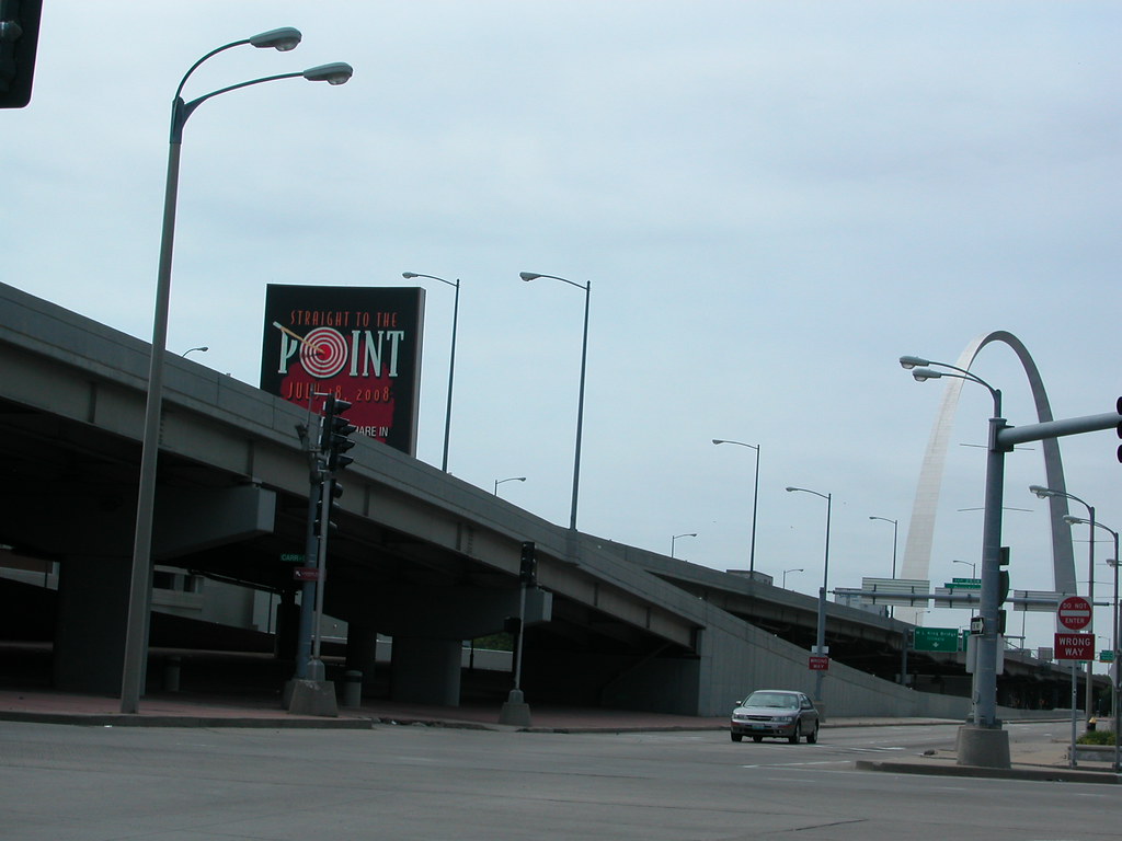
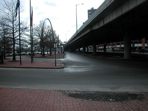
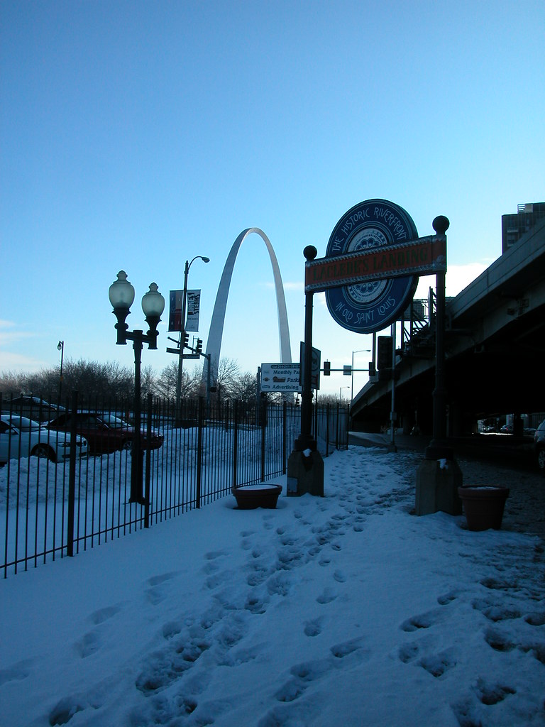
Still, the design competition is a clarion call for vision of a different kind. The GMP acknowledges the spatial obstacles to pedestrian access to the Memorial. In the GMP, there is discussion about the terrible infrastructure on the west and south sides of the Memorial that make pedestrian access difficult. The GMP discusses the moribund riverfront, the dormant east riverfront and other things that make the Memorial grounds a very divine landscape surrounded by an ugly cityscape and divided from urban vitality.

The design competition responds to the GMP by calling for radical reconceptualizing of the cityscape on both sides of the river that frame the Arch grounds. The subtitle of the competition is “Framing a Modern Masterpiece,” indicating the challenge ahead: visionary urban place-making around a magnificent landscape that cuts across the boundaries of many government entities.

This competition thus is as much about politics as design. Mayor Francis Slay and Senator Claire McCaskill are deeply involved in the process. There is little doubt that the competition’s fast track — completion of improvements is slated for 2015 — is driven by political concern rather than interest in truly transformative planning. In an interview, I asked competition manager Don Stastny of Stastny Brun if he had ever been involved in any design competition that had a time line of less than six years between the start of the competition and the projected completion of the design. He said that he had not, save a State Department competition for the destroyed Nairobi embassy.

There is a strong tension between the frank analysis offered by the National Park Service in the GMP and the “get it done” attitude of elected officials. Perhaps that tension is productive in a city that lacks any effective planning ordinance or agency. The National Park Service is playing the catalytic role that a city planning agency should already have done. On the other hand, without the competition’s ambitious pace, good ideas might get lost or watered down through slow implementation. The competition process cuts through parochial politics by forcing St. Louis, East St. Louis, Missouri and Illinois to work together and implement solutions that are not neatly confined to parochial politics of appropriations.

Still, there is no need to have everything done by 2015. I like that early date as a spur to slow-moving local governments. However, I am afraid that date could preclude consideration of larger projects needed for connectivity. The competition cannot produce anything as great as the Memorial, but it need not be reigned in by a fixed, arbitrary timeline. After all, Kiley and Saarinen’s plan was selected in 1948 but not fully completed until 1982.

Boundaries

The boundaries of the competition are exciting, as the map above shows. There are several notable inclusions:

  • The east riverfront, a topic neglected in much of the recent debate on the Arch grounds, is included. In fact, a large part of Malcolm Martin Park is included. Unfortunately, the boundary excludes the Casino Queen site and the MetroLink station. The pedestrian path from Malcolm Martin Park to MetroLink should be included, since the walk currently takes place on an unkempt street without sidewalks.
  • The boundary seems to purposely place both the Eads and Poplar Street bridges inside. The Poplar Street Bridge is aging and due for major overhaul. The competition could create a vision for what a new Poplar Street Bridge would look like. Bike and pedestrian lanes are a must.
  • Kiener Plaza is included in the boundary. While the Old Courthouse is part of the Memorial and needs a more graceful frame than the current state of Kiener Plaza, does the plaza really need to be part of this process?
  • All of the Memorial grounds are included, which is fine, but preservation of the landscape is essential. However, jurors in the competition — and leaders of the CityArchRiver 2015 Foundation — need to be ready to consider proposals that would reloctae or alter the north parking garage (operated by Metro) and the south maintenance facility.
  • I-70 directly west of the Memorial is included, but the boundary does not extend north to capture all of the elevated section. The GMP states that the National Park Service “strongly supports” removal of the highway, but thinks it unfeasible at this time. Why?

Highway Removal

If there has ever been the right time to consider removal of the depressed and elevated lanes, it is now. There is a great converegence between the design competition — where thinking big is encouraged, and reweaving urban fabric is the foundation for the program — and the 2016 opening of the new Mississippi River Bridge that will carry I-70 out of downtown forever. While the end dates of these projects don’t align perfectly, they are too close to leave unexamined. Highway removal need not be underway in 2015 for the ribbon-cutting; if the competition jury endorses any plan for highway removal, the region will have made major progress.

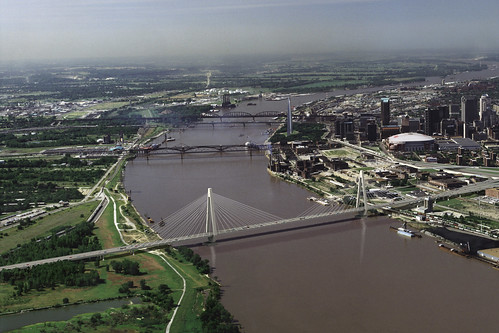
Obviously, the impact of the new bridge on traffic would need to be studied before removal could be planned. The replacement of I-70 should not be set in stone, since a wide boulevard could be as pedestrian-unfriendly as the current I-70/Memorial Drive configuration. Those two considerations are perfect fodder for a team of design professionals to engage. While we have the world’s best architects working on solutions for the Memorial’s connection to the rest of the city, we would be foolish to not encourage them to study one of downtown’s biggest problems.

We have great leadership in the Memorial’s Superintendent Bradley. Tom Bradley has been a patient, thoughtful and progressive player who has managed to channel converging political forces into a positive direction. Bradley weathered the Danforth museum idea, which did nothing to address the real planning issues of the Memorial, and forced normally complacent local leaders into action that has the potential to truly transform downtown. Stastny likewise should be a great manager, since his philosophy is that his clients must determine the choice to have a competition on their own. He’s not a salesman, but an astute facilitator.

A successful competition will consider every entry on its merits, and its jurors will have the courage to endorse the best plan no matter what its political implications may be. We may never again see another international design competition in St. Louis. We must be as wise as our ancestors — nay, wiser.

Categories
Downtown Infrastructure JNEM

Arch View

View looking southwest from the intersection of Cole and Broadway. Lovely, isn’t it?


Categories
Downtown Infrastructure North St. Louis Northside Regeneration Planning

City Hall Asking Right Questions about McEagle Project

by Michael R. Allen

Friday’s St. Louis Business Journal carried two stories on McEagle’s NorthSide project that quoted Deputy Mayor Barbara Geisman and Mayoral Chief of Staff Jeff Rainford. (Articles are available online only to subscribers.) The primary article, “Will Paul McKee and City hall bond?” dealt with the developer’s request that the city guarantee via general revenue half of the $410 million in tax increment financing bonds sought. From the comments in the article, it sounds like City Hall is not ready to roll over on the request.

Rainford says that Mayor Francis Slay is skeptical on the city backing the bonds, and that Slay will only do so under “extraordinary circumstances.” Rainford acknowledged ongoing negotiations between the mayor’s office and McEagle, but the article did not elaborate on what “extraordinary circumstances” would be.

Deputy Mayor Geisman went further, stating that the city doesn’t know enough about the project yet to consider a request for general revenue backing. The article ends with a frank — and encouraging — quote from Geisman: “Lots of people ask for lots of things; it doesn’t mean they’re going to get it.”

While there is much to admire in the scope of McEagle’s vision as it has been laid out, the TIF request is abrupt and based on unsubstantiated financial information. The size of the request alone raises questions, but the push for city backing is premature. As the Business Journal article notes, the only three times when the city backed TIF bonds — St. Louis Marketplace, the convention hotel and Pyramid’s acquisition of One City Center — the city has ended up on the hook for failed or troubled development projects. McEagle has yet to demonstrate that its project would be any different.

I am heartened that City Hall has shifted gears from largely favorable comments to on-point comments. Hopefully this indicates a stance of tough bargaining, because a city that is eliminating jobs and implementing furloughs cannot afford to throw the treasury open for an untested vision.

That said, the second article, “McKee eyes land swap with MoDot for first phase,” showed some of the possibilities of the McEagle development. McEagle wants to eliminate the 22nd street ramps and use that site for new office development, and it seems that City Hall favors that approach. Readers know how much I want City Hall to support eliminating needless highway components, so I am glad that Geisman seems positive about removal of some of the most useless highway infrastructure in the region.

I have little to complain about the 22nd Street part of the McEagle vision: it removes useless and divisive infrastructure, adds density, does not affect any houses, businesses or historic buildings and it could result in a termination of the visually-challenged Gateway Mall other than a chain link fence. McEagle wants this to be the first phase — why not separate this area out into its own redevelopment area with its own enabling legislation?

One major problem with the McEagle project has been the lack of public-side planning. If city government was vigilant about setting and enforcing urban planning goals, the McEagle project would conform to those objectives and not be as problematic as it has been. Barring real planning, City Hall ought to use its powers to make sense of the project for the benefit of the city. Beyond the TIF deal, City Hall should look at the possibility of breaking the project down into smaller redevelopment areas, creating real historic preservation planning and placing the promises unveiled on May 21 into an actual contract between the city and the developer. A good deal is possible, and City Hall is at the center of that.

Categories
Downtown I-70 Removal Infrastructure North St. Louis Northside Regeneration Planning

Six Ways to Remove a Freeway — How About Seven?

by Michael R. Allen

Six Case Studies in Freeway Removal is a an excellent overview of successful efforts to eliminate interstate highways in urban areas that created barriers. While there are examples from large cities like San Francisco, Toronto and Vancouver where one might expect progressive government, there are also studies from Milwaukee and Chattanooga where advocates for reconnecting the urban fabric faced greater odds.

There are constant themes in each project profiled in Six Case Studies in Freeway Removal: beautification and functionality were major goals of cities that removed freeways or freeway sections, spillover traffic was absorbed without major new congestion and freeway removal almost always lead to higher property values. St. Louis leaders contemplating the mess at the western edge of the Gateway Arch grounds ought to consider the findings of this study, and commission one aimed at the particular local problem that I-70 poses.


One of my first reactions to the case studies from other cities is that the I-70 problem is not that big. Taking the logical dimension of removal from the Poplar Street Bridge on the south to Cass Avenue on the north, one sees that we don’t have as long or as vital a stretch of highway as other cities removed. What we will have in a few years, after the new river bridge opens, is a redundant second section of an interstate highway that disrupts the connection between downtown and the riverfront.

Is St. Louis ready to join the ranks of the cities that have found the leadership needed to think big? A few months ago, I might have been pessimistic. Now, I see that City Hall and many leaders are willing to take a major urban planning risk with McEagle Properties’ NorthSide project. Putting aside the details of NorthSide, that project takes a leap of faith — the scope is vast, the cost great and the potential for changing the central city tremendous. Part of the project even involves removing interstate highway infrastructure, the 22nd Street ramps connecting to Interstate 64. The project aims to capture southbound I-70 exit traffic and send it onto Tucker Boulevard, not eastward toward Memorial Drive. That flow could lessen traffic volume on the old I-70 and Memorial Drive.

Is there a connection between NorthSide and removal of I-70 downtown? Not yeat, but there is a binding tendency in each project: big-picture economic development planning. While NorthSide’s proponent is its developer, proponents of removing I-70 are citizens who see tremendous development opportunity along a human-scaled street. The removal of I-70 would weave the riverfront back into downtown, and it would create acres of land ripe for transformative downtown development. Like NorthSide, the process could take decades, but the results would be redevelopment on a scale beyond our wildest dreams. Add in the Chouteau Greenway project, and in thirty years Downtown could be ringed not by bleak interstate, asphalt parking and towing lots and vacant buildings but by connections to exciting new projects and renewed old neighborhoods.

Other cities took the leap of faith needed to set this level of vision into motion. Will St. Louis?

Categories
Downtown Infrastructure JNEM Laclede's Landing

Beautiful View?

Categories
2009 St. Louis Election Infrastructure South St. Louis Streets

Pointless Change at Grand and Chouteau

by Michael R. Allen

At last night’s candidate forum sponsored by the 15th Ward Democrats, Comptroller Darlene Green received applause for an issue not directly related to her campaign. When asked about red light cameras, she said that she definitely knew of a camera that needs to be removed: the red light camera at Grand and Chouteau. Mayor Francis Slay arrived during this time, so Green directly addressed the mayor from the podium.

The problem with the light, Green said, is that it is part of changes to the intersection that forces the three lanes of southbound traffic on Grand into two with a left-turn-only lane at Chouteau. Past Chouteau, the road is back to three lanes. Rarely do left turns clog the southbound lanes, and there are always vehicles in the inside lane that have to move over at the last minute to avoid getting a camera ticket from running straight in a turn-only lane.

The audience burst into applause, for good reason. That intersection reconfiguring is one of the silliest in the city. Before the camera went up, I joined many drivers in ignoring the changes. Since I am not an alderman, getting a red light ticket fixed might be difficult, so I now reluctantly obey the pointless changes there.

All of the red light cameras violate the spirit of the Fourth Amendment to the U.S. Constitution and any sensible view of law enforcement. I hope that Comptroller Green’s recommendation is followed, but we need to pull them out completely. The changes at Grand and Chouteau are blatantly revenue-driven, and impede smart traffic flow there. They need to be undone. Then we need to get rid of the remaining red light cameras and find a more dignified, constitutional way of enhancing city revenue.

Categories
Housing Hyde Park Infrastructure North St. Louis Urbanism

Cut Off From Hyde Park

by Michael R. Allen

Eleventh Street continues north of Branch Street for two blocks, abruptly dead-ending where it meets the embankment of I-70. I-70 hems in the street and the pocket of residential Hyde Park that remains severed from the neighborhood. The city furthered this severance by officially drawing the Hyde Park boundary at I-70, which is certainly a barrier but nothing that defines any boundary of a neighborhood that has always started at the Mississippi River.

I love these two houses on the west side of Eleventh Street north of Branch. There are many small shaped-parapet bungalows in Hyde Park, built of pressed brick with wooden front porches. Houses like these line Agnes and Destrehan streets back in official Hyde Park. These homes date to the 1920s, when they went up en masse on undeveloped sites in the south end of the neighborhood. Few of those houses enjoy as dramatic a setting as these two now do. The highway in the back yard, giant billboards on each side — the only comfort found in one of these houses is its well-kept neighbor. The brick sidewalk in front adds another reminder of the lost connection with the historic world of Hyde Park.

Categories
Industrial Buildings Infrastructure Mississippi River North St. Louis

Joseph F. Wangler Boiler & Sheet Metal Works

by Michael R. Allen

I report with relief that the latest footprint of the proposed Mississippi River Bridge at St. Louis reduces the number of historic buildings proposed for demolition to less than six. (Alas, the footprint will cover the site of the “big mound” at Broadway and Mound streets, which is potentially one of the city’s most significant Native American archeological sites.) One of the buidlings in the path of the ramps connecting the bridge to Cass Avenue is the complex once occupied by the Joseph F. Wangler Boiler & Sheet Metal Works Company, located on the superblock (Mullanphy is closed) bounded by 10th, Howard, 9th and Cass. Much of the complex dates to mid-20th-century expansion, but at the core is a taller 19th-century brick building bearing the name of the company.

The Wangler works warranted a mention in E.D. Kargau’s 1893 Mercantile, Industrial and Professional St. Louis. Kargau noted that among St. Louis’ many industrial concerns are but a few boiler makers, Wangler being one. The Wangler works started in 1864 as Cantwell & Wangler before falling under control of Joseph F. Wangler, a Pittsburgh native. The first location was at 1019-23 Main Street, but the firm need space and moved west to the block where its name can still be read.

According to Kargau, the Wangler shops “are equipped with the most approved and modern machinery and the work turned out from them is unsurpassed in exact workmanship, durability and quality of material and are always closely examined before being sent out” (page 295). Among these renowned works were, of course, boilers as well as sheet iron work, storage tanks and tanks for ice machines.

Kargau had much praise for Wangler and his sons as business leaders, stating that they “are at all times ready to participate in every movement for the welfare and in the interest of the community” (page 296). Long gone are these men, their company and the spirit of enlightened civic business culture. We have only a few buildings from the boiler works to remind us of the Wanglers’ good work, and not for more than another decade. Some may find a new bridge to be a work in the interest of popular welfare, but the fruits of employment found at the boiler works provided more bread to the common person than the new bridge ever will.