Categories
Downtown Green Space I-70 Removal JNEM Riverfront

A Grand Plan for Memorial Drive

by Michael R. Allen

Image by Jeremy Clagett for City to River.

Readers of Ecology of Absence know that this author has long favored a holistic change to the current configuration of Memorial Drive and I-70 at the Jefferson National Expansion Memorial. The highway and the street together create a visual barrier and physical obstacle course between the downtown core and the lovely Arch grounds, and both need to be removed and replaced with a pedestrian-friendly at-grade thoroughfare.

Today, the citizen organization City to River launched its website that presents a thoughtful, creative approach toward building a new Memorial Drive. The analysis and imagery of the website come at a wonderful moment, right after the Framing a Modern Masterpiece design competition jury has chosen the nine design teams that will create full entries. May the design teams spend time contemplating the City to River proposal, and may the design competition’s sponsors keep the door open for any team that may wish to embrace a radical way to renew the riverfront connection.

Categories
Art Downtown Events JNEM Riverfront

"Faces of the Riverfront" Exhibit Opens This Sunday


The Jefferson National Expansion Memorial will host a special exhibit from St. Louis artist Sheila Harris at the Old Courthouse from Feb. 14 through Aug. 22, 2010. Created especially for the memorial, the exhibit consists of nearly 40 watercolor paintings of buildings that once stood on the Arch grounds. Harris’ “portraits” of buildings depict structures from several generations of the city’s architectural history illustrating how the landscape of the riverfront evolved over time.

The exhibit will launch with an artist’s reception on Sunday, February 14, at 2:00 p.m.

Categories
Downtown Green Space I-70 Removal JNEM

Looking at the Original Plan for the Jefferson National Expansion Memorial

by Michael R. Allen

This snapshot from the Old Courthouse exhibit on the original Jefferson National Expansion Memorial design competition shows the winning site plan submitted by architect Eero Saarinen and landscape architect Dan Kiley in 1948. Below is an illustrated version of that plan.

This site plan was not built due to programmatic changes by the architects and the National Park Service (NPS). Obstacles that forced site changes included the agreement between NPS and the Terminal Railroad Association to retain the railroad tracks through the site and the need to elevate I-70 over the tunnel at the Eads Bridge. The original design placed the Arch closer to the river in anticipation of railroad removal, and placed the interstate in a tunnel (shown at top) with a Third Avenue at grade above not unlike the one envisioned by advocates today.

Other changes from the original plan:

Kiley reoriented the layout of the Memorial for a nearly symmetrical plan.

The Campfire Theater was a programmatic requirement of all national parks when the competition was held, but dropped before completion of the Memorial.

Restaurants perched over the riverfront were never built due to the railroad issue. The tunnel required high flood walls that changed the east end of the site that was originally supposed to slope down to meet the levee.

The designers and NPS abandoned plans for an architectural museum on the grounds and placed the “Historic Museum” under ground (the Museum of Westward Expansion).

The designers and NPS abandoned plans for a “frontier village” of reconstructed French Colonial buildings in the northwest part of the site, as well as a group of such buildings around the Old Cathedral.

Entrance to the Arch trams would have been through the reconstructed Old Rock House, shown here between the Arch legs.

The park would have extended all of the way north to the Eads Bridge.

The final landscape work at the Memorial took place in 1982, nearly forty years after the selection of the plan by Saarinen and Kiley. Congressional funding delays are largely responsible for the slow implementation. The Gateway Arch was completed in 1965, after Saarinen’s death. This slow pace of development of one of the nation’s grandest integrated works of modern landscape and architecture no doubt was frustrating, but the result was worth the wait.

Preservation of the relatively young landscape is integral to the current design competition. Still, some of the early ideas of Saarinen and Kiley may be worth contemplation by designers in the current competition. Part of the Memorial enjoys the protection of the nation’s highest level of historic designation, that of the National Historic Landmark. The rest does not. That is not an invitation to alter the landscape, but a potential window for sensitive changes.

Any changes made will be interpretive, and interpreting what is authentic about the landscape is a huge challenge. Architects by nature wish to transform places, and that inclination must be tempered by understanding of Saarinen and Kiley’s plan and its evolution. That’s why the competition requires teams to include someone who understands federal preservation laws — laws that are not prohibitions on change but guiding restrictions.

Certainly, there are two parts of the Memorial that developed due to utilitarian need rather than architectural inspiration — the north and south nodes, where the hulking parking garage and the south maintenance building stand. The maintenance building and the parking garage should be moved off of the grounds, and those sites thrown open to new purposes. Many of us advised Senator John Danforth that should he wish to build a museum at either site, he would have faced little serious opposition. In fact, the south end was where Saarinen and Kiley placed their main museum building in the first plan. Removal of the garage would allow for another intriguing change — removal of the too-wide and underused extension of Washington Avenue on the north side of the Memorial.

Many of the needed changes that sponsors of the design competition seek — better connections, stronger link to river and programmatic venues that attract visitors — are in the original plan. Saarinen and Kiley’s original plan would have made moot any future design competition focused on activation and connectivity.

The inclusion of an architectural museum was prescient, given today’s St. Louis Building Arts Foundation effort. Retention of some sense of the historic riverfront buildings is in keeping with later preservation philosophy that holds that total destruction is never desirable, even in large-scale renewal. Most of all, the designers blended the landscape into the city by bridging the interstate and drawing the Memorial straight into the north riverfront we now call Laclede’s Landing. Eero Saarinen and Dan Kiley left a blueprint for a connected, active Memorial that the current design competition may realize. That blueprint was bestowed with genius and care for the site’s designed beauty. Before designers attempt to rise to that level of genius, they should take a look at the original winning entry.

Categories
Downtown Green Space JNEM

Duffy: Design Competition Promises to Be Bold

by Michael R. Allen

Bob Duffy has an insightful commentary in the St. Louis Beacon entitled “The competition to improve Arch grounds promises to be bold, creative”. I recommend a full read. However, Duffy’s recap of yesterday’s briefing for potential competitors in the design competition includes some hopeful signs that the competition process will be fruitful for visionary thinking.

For one thing, the competitors will be forbidden contact with the sponsors and jurors. Writes Duffy:

Competitors are forbidden contact with competition sponsors and jurors, and if this rule is broken, the offending team will be disqualified. There is to be no corporate or personal lobbying. Strict communications protocols have been established, and all information must be requested through competition management.

Competition manager Don Stastny also reiterates that the process and short timeline is meant to guarantee, not stifle, visionary solution-making. From Bob Duffy:

The guidelines and timelines for the competition are meant not to put obstacles in the paths of designers, architects and artists who may compete, but to create an environment in which the teams might do their best work.

Sounds good to me.

Categories
Architects Downtown Green Space JNEM

The Design Competition’s Jury, and Its Grand Jury

by Michael R. Allen

This morning, the CityArchRiver 2015 Foundation announced the jury that ultimately will select the winning entry in the International Gateway Arch Design Competition. The eight jurors are:

Robert Campbell, architecture critic at The Boston Globe and contributing editor for Architectural Record;

Gerald Early, Merle Kling Professor of Modern Letters and Director of the African and Afro-American Studies at Washington University in St. Louis;

Denis P. Galvin, former Deputy Director of the National Park Service;

Alex Krieger, founding principal of Chan Krieger Sieniewicz, architecture and urban design firm and professor at the Harvard School of Design, Cambridge, Mass.;

David C. Leland, an urban strategist and managing director of the Leland Consulting Group, Portland, Ore.;

Cara McCarty, curator of the Smithsonian’s Cooper-Hewitt National Design Museum, New York City;

Laurie D. Olin, partner and landscape architect of the OLIN Studio, Philadelphia;

Carol Ross Barney, founder and Principal of Ross Barney Architects, Chicago.

Notably, there is only one St. Louis resident on the panel, Gerald Early. However, the fact that the local juror is a scholar of cultural history and not someone deeply tied to the local architectural community is refreshing. Cara McCarty is also a scholar with a local connection; she used to serve as a curator at the St. Louis Art Museum.

Some wonder why there is not more local representation on the jury, and that is a valid question. Certainly there are local architectural critics, professors of architectural history, architects and designers whose credentials match or trump those found in this jury. There has been rumbling from local architects that the program requirements for the competition is out of reach for local firms, and jury spots could have provided consolation.

However, the jury would not do well for St. Louis if it were fraught with the politics of representing local talent or special interests. The jury must be able to independently evaluate the submissions free from the wires of local politics. That goal has been accomplished. We now will have a rare opportunity to watch architectural heavyweights from other places examine St. Louis, which should be a welcome breath of fresh air.

The jury’s composition, however, should not consign local critics to passivity. In fact, having St. Louis’ leading critics and designers outside of the official process allows them the free reign of critical engagement that only those with deep local understanding can offer. All of us concerned with the competition should step up to demand excellence, praise good decisions, call out bad decisions and work to guarantee that the design competition is truly a great moment for our city.

The decision to have a competition, after all, is political. Politics can water down great ideas. The ambitious deadline for completing the winning design is a political threat to realizing a transformative change in connections between downtown and the riverfront. The jury can’t tackle that problem — that’s up to the rest of us. Citizens remain the grand jury.

Categories
Downtown Green Space I-70 Removal Infrastructure JNEM

International Design Competition Will Look at a Big Picture

by Michael R. Allen

The New Year will bring to St. Louis an international architectural competition centered on the Jefferson National Expansion Memorial. The only other such competition to take place in St. Louis also concerned the Memorial; in 1948, a competition selected for the Memorial the designed landscape of architect Eero Saarinen and landscape architect Dan Kiley. That selection gave a declining American river city a triumphant architectural boost and a place in postwar architectural history. The Gateway Arch designed by Saarinen became the internationally-recognized symbol of the city.

Will the new design competition lead to the implementation of a design as boldly modern as the Arch? Probably not. After all, the program for the competition is realization of the National Park Service’s new General Management Plan (GMP) for the Memorial. That plan’s preferred alternative is not a blueprint for radical upheaval of a significant landscape but a corrective program for finding remedies to that landscape’s flaws. The new CityArchRiver 2015 Foundation, spearheaded by attorney Walter Metcalfe, Mayor Francis Slay, Memorial Superintendent Tom Bradley and national parks advocate Lynn McClure, is sponsoring the competition and raising money for implementation of the winning entry.

The competition thus wisely avoids a fruitless effort to construct a parallel icon near the Arch. The architectural genius of the Gateway Arch is elegant and unparalleled. Few contemporary architects — or even starchitects with their tedious “signature” touches — could match Saarinen’s vision. Likewise, the Kiley landscape is a masterpiece. To attempt to add to the Memorial design through iconic design is folly. John Danforth’s museum proposal was fueled by the incorrect assumption that any large new building on the Memorial grounds could be anything other than pretty clutter.

Still, the design competition is a clarion call for vision of a different kind. The GMP acknowledges the spatial obstacles to pedestrian access to the Memorial. In the GMP, there is discussion about the terrible infrastructure on the west and south sides of the Memorial that make pedestrian access difficult. The GMP discusses the moribund riverfront, the dormant east riverfront and other things that make the Memorial grounds a very divine landscape surrounded by an ugly cityscape and divided from urban vitality.

The design competition responds to the GMP by calling for radical reconceptualizing of the cityscape on both sides of the river that frame the Arch grounds. The subtitle of the competition is “Framing a Modern Masterpiece,” indicating the challenge ahead: visionary urban place-making around a magnificent landscape that cuts across the boundaries of many government entities.

This competition thus is as much about politics as design. Mayor Francis Slay and Senator Claire McCaskill are deeply involved in the process. There is little doubt that the competition’s fast track — completion of improvements is slated for 2015 — is driven by political concern rather than interest in truly transformative planning. In an interview, I asked competition manager Don Stastny of Stastny Brun if he had ever been involved in any design competition that had a time line of less than six years between the start of the competition and the projected completion of the design. He said that he had not, save a State Department competition for the destroyed Nairobi embassy.

There is a strong tension between the frank analysis offered by the National Park Service in the GMP and the “get it done” attitude of elected officials. Perhaps that tension is productive in a city that lacks any effective planning ordinance or agency. The National Park Service is playing the catalytic role that a city planning agency should already have done. On the other hand, without the competition’s ambitious pace, good ideas might get lost or watered down through slow implementation. The competition process cuts through parochial politics by forcing St. Louis, East St. Louis, Missouri and Illinois to work together and implement solutions that are not neatly confined to parochial politics of appropriations.

Still, there is no need to have everything done by 2015. I like that early date as a spur to slow-moving local governments. However, I am afraid that date could preclude consideration of larger projects needed for connectivity. The competition cannot produce anything as great as the Memorial, but it need not be reigned in by a fixed, arbitrary timeline. After all, Kiley and Saarinen’s plan was selected in 1948 but not fully completed until 1982.

Boundaries

The boundaries of the competition are exciting, as the map above shows. There are several notable inclusions:

  • The east riverfront, a topic neglected in much of the recent debate on the Arch grounds, is included. In fact, a large part of Malcolm Martin Park is included. Unfortunately, the boundary excludes the Casino Queen site and the MetroLink station. The pedestrian path from Malcolm Martin Park to MetroLink should be included, since the walk currently takes place on an unkempt street without sidewalks.
  • The boundary seems to purposely place both the Eads and Poplar Street bridges inside. The Poplar Street Bridge is aging and due for major overhaul. The competition could create a vision for what a new Poplar Street Bridge would look like. Bike and pedestrian lanes are a must.
  • Kiener Plaza is included in the boundary. While the Old Courthouse is part of the Memorial and needs a more graceful frame than the current state of Kiener Plaza, does the plaza really need to be part of this process?
  • All of the Memorial grounds are included, which is fine, but preservation of the landscape is essential. However, jurors in the competition — and leaders of the CityArchRiver 2015 Foundation — need to be ready to consider proposals that would reloctae or alter the north parking garage (operated by Metro) and the south maintenance facility.
  • I-70 directly west of the Memorial is included, but the boundary does not extend north to capture all of the elevated section. The GMP states that the National Park Service “strongly supports” removal of the highway, but thinks it unfeasible at this time. Why?

Highway Removal

If there has ever been the right time to consider removal of the depressed and elevated lanes, it is now. There is a great converegence between the design competition — where thinking big is encouraged, and reweaving urban fabric is the foundation for the program — and the 2016 opening of the new Mississippi River Bridge that will carry I-70 out of downtown forever. While the end dates of these projects don’t align perfectly, they are too close to leave unexamined. Highway removal need not be underway in 2015 for the ribbon-cutting; if the competition jury endorses any plan for highway removal, the region will have made major progress.

Obviously, the impact of the new bridge on traffic would need to be studied before removal could be planned. The replacement of I-70 should not be set in stone, since a wide boulevard could be as pedestrian-unfriendly as the current I-70/Memorial Drive configuration. Those two considerations are perfect fodder for a team of design professionals to engage. While we have the world’s best architects working on solutions for the Memorial’s connection to the rest of the city, we would be foolish to not encourage them to study one of downtown’s biggest problems.

We have great leadership in the Memorial’s Superintendent Bradley. Tom Bradley has been a patient, thoughtful and progressive player who has managed to channel converging political forces into a positive direction. Bradley weathered the Danforth museum idea, which did nothing to address the real planning issues of the Memorial, and forced normally complacent local leaders into action that has the potential to truly transform downtown. Stastny likewise should be a great manager, since his philosophy is that his clients must determine the choice to have a competition on their own. He’s not a salesman, but an astute facilitator.

A successful competition will consider every entry on its merits, and its jurors will have the courage to endorse the best plan no matter what its political implications may be. We may never again see another international design competition in St. Louis. We must be as wise as our ancestors — nay, wiser.

Categories
Downtown Green Space JNEM

International Design Competition to Invigorate the Gateway Arch Starts Today

Goal is to “Frame a Modern Masterpiece” and Connect the Gateway Arch with the Mississippi River and the St. Louis Region by 2015

FOR RELEASE: December 8, 2009

Contact: Tom Bradley, Superintendent
Jefferson National Expansion Memorial
(314) 655-1600

Jeff Rainford
Office of St. Louis Mayor Francis G. Slay
(314) 622-3201

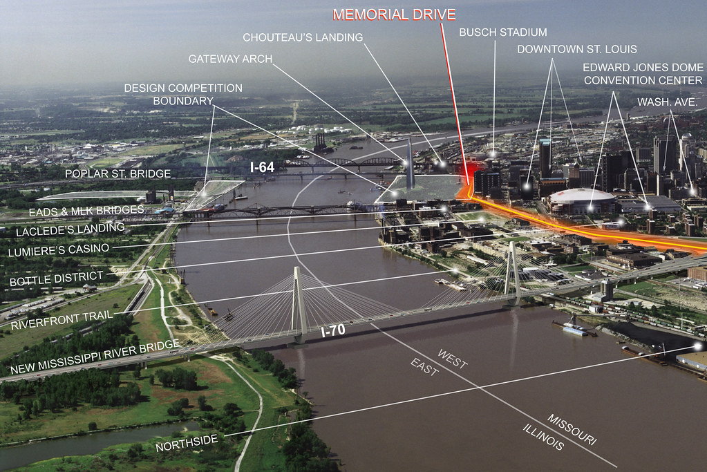
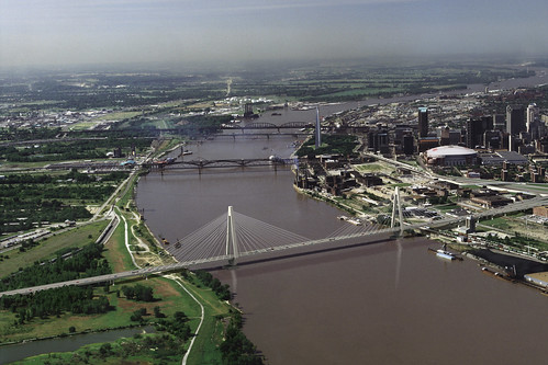
ST. LOUIS, Mo. – The National Park Service and St. Louis Mayor Francis Slay today launched an international design competition to invigorate the park and city areas surrounding of one of the world’s most iconic monuments, the Gateway Arch in St. Louis.

“The competition begins today,” said Tom Bradley, Superintendent of the Jefferson National Expansion Memorial, which includes the Gateway Arch. “This competition is a unique and important opportunity to integrate the Arch and the park surrounding it into the fabric of the city and region and embrace the Mississippi River and its east bank. It’s an opportunity to energize the park with new amenities and attractions. By achieving these objectives, we will design people into the area – and establish a national model for urban parks.”

The winning design will be announced in October 2010, with the resulting work completed by October 28, 2015 – the 50th anniversary of the completion of the Arch.

“Critical stakeholders are engaged and the architectural and design communities are excited to get started,” said Slay, who, with Bradley, is a member of the CityArchRiver2015 Foundation, a nonprofit organization created to drive the effort. Also represented in that group are regional business and university leaders, national park advocates and architects.

“We’re very lucky to now have Tom Bradley as a partner in this initiative,” said Slay. “He has worked diligently to drive federal action, solicit community input, and engage and reassure the park advocacy community, all of which have been absolutely essential to launching this competition.”

The competition – “Framing a Modern Masterpiece: The City + The Arch + The River 2015” – is called for in the National Park Service’s new General Management Plan, which was developed with extensive public input over an 18-month period, and approved on November 23, 2009.

“Engaging the wider community, including and extending far beyond the St. Louis region, has been and will continue to be an important element in this process,” said Slay.

The competition will invite teams to create a new design for the Arch grounds and surrounding areas with 10 goals in mind:

* Create an iconic place for the international icon, the Gateway Arch.
* Catalyze increased vitality in the St. Louis region.
* Honor the character-defining elements of the National Historic Landmark.
* Weave connections and transitions from the city and the Arch grounds to the Mississippi River.
* Embrace the Mississippi River and the east bank in Illinois as an integral part of the national park.
* Mitigate the impact of transportation systems.
* Reinvigorate the mission to tell the story of St. Louis as the gateway to national expansion.
* Create attractors to promote extended visitation to the Arch, the city and the river.
* Develop a sustainable future for the Jefferson National Expansion Memorial.
* Enhance the visitor experience and create a welcoming and accessible environment.

The competition is being organized and managed by Donald Stastny, one of the nation’s most experienced design managers. Stastny is the chief executive officer of StastnyBrun Architects in Portland, Ore., and has served as professional advisor for more than 35 design competitions. Among them are the recent Flight 93 National Memorial in Stonycreek Township, Pa., the Oklahoma City National Memorial, the new U.S. embassy in London and Disney Concert Hall in Los Angeles.

Stastny will instruct and assist an eight-person jury. The names of jury members – from design, architecture, landscape architecture and related fields – will be announced in early January 2010, closer to the deadline for initial registration for the competition.

“The challenge is great – to take one of America’s first urban parks and weave it into the fabric of the region,” Stastny said. “I’m confident that this competition will foster an environment in which leading and emerging design professionals can do their best work and walk in Eero Saarinen’s footsteps. It’s a once-in-a-lifetime opportunity for the participants – and I’m proud to be involved.”

“This competition will honor the character-defining elements of the National Historic Landmark, which includes the Gateway Arch and its grounds,” said Lynn McClure, Regional Director for the National Parks Conservation Association, America’s leading voice for our national parks.

“The national park, downtown St. Louis, the riverfront and the Illinois side will finally be brought together as a vibrant and exciting destination,” said McClure, who is also a member of CityArchRiver2015 Foundation.

Dr. Robert Archibald, President and CEO of the Missouri Historical Society, praised the competition plan, stating, “This park symbolizes the American spirit, the sense of optimism and energy. The Gateway Arch is truly stunning; as magnificent today as it was the day it was completed. We need now to free it of its isolation and connect it to the region and the river on whose banks it sits.”

Archibald was among a small group of civic leaders tapped two years ago by Mayor Slay to explore new options to connect the city, the Gateway Arch and the river, and to bring new vitality to the riverfront.

This new competition honors the spirit of the 1947 national challenge that inspired architect Eero Saarinen’s Gateway Arch design. In the effort to produce a memorial to Thomas Jefferson’s Louisiana Purchase and the era of American Westward expansion, the jury chose the most audacious entry – a gleaming 630-foot stainless steel arch. It was the first of several masterpieces by the gifted but short-lived Saarinen.

Completed in 1965, the Gateway Arch instantly became an international destination and won immediate recognition as one of the world’s premier works of public art. The grounds immediately surrounding it, designed by the late Dan Kiley, are also widely recognized as a landscape masterpiece. However, those grounds, and the city streetscape, highways, and the Mississippi riverfront which they abut, lack the “buzz” of constant activity associated with a vibrant urban park – one of the issues the competition is meant to address.

In addition to Superintendent Bradley, Mayor Slay and Lynn McClure, CityArchRiver2015 Foundation also includes: Bruce Lindsey, Dean of the College of Architecture and Graduate School of Architecture and Urban Design at Washington University in St. Louis; Walter Metcalfe Jr., an attorney with Bryan Cave LLP and another of Mayor Slay’s original team of civic leaders; Deborah Patterson, President of the Monsanto Fund and director of social responsibility for the Monsanto Company; and, Dr. Vaughn Vandegrift, Chancellor of Southern Illinois University Edwardsville. This volunteer group has coalesced over the last six months as the National Park Service’s General Management Plan took shape.

Financial contributions are being handled by the Greater St. Louis Community Foundation, a public charity with more than $140 million in charitable assets and representing more than 350 individual funds.

Contributors to the design competition include: Emerson, Gateway Center of Metropolitan St. Louis (Malcolm W. Martin Memorial Park), Peter Fischer, Emily Rauh Pulitzer, Civic Progress, Wachovia Wells Fargo Foundation, Danforth Foundation, Bryan Cave LLP, Greater St. Louis Community Foundation, National Park Foundation, Monsanto, Alison and John Ferring, Bank of America and donors who choose to remain anonymous.

Additional information can be found at www.cityarchrivercompetition.org.

###

Categories
Downtown Historic Preservation JNEM

Moving Ahead on South Fourth Street

by Michael R. Allen

The on-again, off-again rehab of the elegant commercial building at 904 S. Fourth Street just south of downtown is definitely “on” again. That’s a good sign in this slow market, and hopefully a good sign for the larger but slow-moving Chouteau’s Landing project of which this building is part. The “other” Landing’s developer, Chivvis, has succeeded in rehabbing two other commercial buildings on Fourth Street, and is planning a major rehab of the Powell Square into studio space with a photography museum as an anchor.

Located just a stone’s throw from Busch Stadium, the South Fourth area is ripe for redevelopment. One of the problems, of course, is that are retains few historic buildings, having lost many to the construction of surface parking for the old stadium and downtown workers. What’s left is scattered, but that provides interesting opportunities for new construction.

The building at 904 S. Fourth Street is part of a more intact section on the east side of the street north of the MacArthur Bridge. That area is now listed in the National Register of Historic Places as the South Fourth Street Commercial Historic District (nomination by Karen Bode Baxter, Tim Maloney and others.) According to the nomination, the building at 904 S. Fourth dates to between the publication of Pictorial St. Louis in 1875 and the Hopkins Fire Insurance Map in 1883. Since St. Louis building permit records from before 1876 no longer exist and permits from the next decade are often incomplete, those two references are invaluable at assigning dates to buildings without permit records.

There are two noteworthy features of the Italianate-style building. First, its cast iron storefront carries the maker’s mark “Christopher & Company” rather than Christoper & Simpson, which was the maker’s name after 1874 and is more commonly seen. However, the building does not appear on the 1875 atlas. The second oddity here is that the south bays of the building were lopped off around 1917 to make way for the railroad approach to the Municipal (later MacArthur) Bridge. Originally, this building was symmetrical. The nomination states that the Eberle & Keyes Undertaking Company — as in bodies — was an early tenant.

Across a parking lot to the north is an intriguing building with a tower-style rounded corner. This building dates to 1887 and housed many doctor’s offices over the years. The back drop here is stunning — the majestic bridge approach still active with rail traffic, the rising masses of the industrial buildings closer to the river, and the downtown street canyon to the north. South Fourth might lack an intact built environment, but it has an urban scenic quality that is very attractive. Imagining the potential is not difficult.

There are some connectivity problems. The rail bridges are visual barriers, but they add to the charm. The barrier here is to the east, where I-55 walls off Fourth Street from Chouteau’s Landing proper. Something has to be done there before this area will really “pop” with development. The likely major design competition surrounding the Jefferson National Expansion Memorial next year provides a great opportunity to examine the connection between this south end of downtown and the river. Removal of I-55 is not possible, but removal of I-70 on the other side of the Poplar Street Bridge could open up an easy walk to the river from South Fourth. Whatever happens, the design competition ought to be open to big-picture thinking that would benefit the development efforts on South Fourth as much as the downtown tourist experience.

Categories
Downtown Infrastructure JNEM

Arch View

View looking southwest from the intersection of Cole and Broadway. Lovely, isn’t it?


Categories
Downtown JNEM Laclede's Landing Riverfront Streets

Making a Difference on the Riverfront

by Michael R. Allen


The southern flank of the mighty Eads Bridge has received a major landscape upgrade, due to the efforts of Metro, the Jefferson National Expansion Memorial and the Laclede’s Landing Redevelopment Corporation. That is to say, the strip between the bridge approach and Washington Avenue actually now is landscaped! The difference between the formerly part-mulch, part-dirt terrain and the new verdant tree-planted, grassy, flowery setting could not be more stark.

For years, this area was a disgraceful disarray in an area marred by many such urban design problems, including the intrusive elevated section of I-70, the parking garage barrier on the northern edge of the Memorial and the lackluster riverfront itself. The “Washington Avenue Beautification Project” does not resolve these larger issues, but vanquishes the terrible appearance of a very-visible area. Pedestrians on the Eads Bridge can now look out at the Gateway Arch and grounds, and look down and see an extension of that inviting park setting.

I do have a quibble with the project concerning the lack of sidewalk on most of this side of Washington. (The other side of the street has a continuous sidewalk.) The photograph on the left shows the sidewalk running east from Second Street to First Street, while that on the right shows the strip running west.

Between Second Street and Memorial Drive, the trees are planted far out from the bridge, making addition of a sidewalk in the future difficult without removing a lane of the street. However, here Washington has four overly-wide lanes, and narrowing is highly desirable. The sidewalk would ultimately connect to the Eads Bridge pedestrian lane, allowing for an easy walk from the Landing up to the bridge deck.

Addition of metered parking here — something that Metro, operator of the garage, would likely oppose — would be desirable. Meters would relieve parking problems on the Landing and calm traffic. However, a continuous sidewalk would be needed. Perhaps this issue can be explored in any design competition that the National Park Service (NPS) undertakes for the Memorial. NPS’ draft general management plan for the Memorial identifies the parking garage site as potentially worth repurposing, so this corridor could be transformed at some point.

Of course, the sidewalk would lead westward walkers out into the morass of the Eads Bridge/Memorial Drive/Washington Avenue intersection. This intersection may be the most confusing in the city! Hopefully any design competition will lead to resolution of this problem, which plagues one of the Memorial’s key entry points. Removal of the interstate is the most direct way to clarify traffic issues here, but that removal is probably on a slower track than the design competition timeline. Who knows? Perhaps the design competition will be the impetus for grad civic thinking on urban design, and our political leaders will embrace a visionary change downtown like those who laid out the Memorial did so long ago.


For now, the most-traveled pedestrian path between downtown and the Landing is right here. Can’t see the path? Well, look carefully. There is a gate-sized opening in the fence of this parking lot on Second Street. People walk back and forth across this lot all day long, because it remains the most direct link between the Landing and downtown. It does not require much imagination to recognize that there is a major connectivity issue here. A sidewalk on Washington would have helped, although the larger disconnect between the riverfront and downtown remains the big problem.

The Washington Avenue Beautification Project points the way to a realistic way to implement changes to the riverfront that will add up to transformative action. While we need visionary leadership on the riverfront design challenge, we also need resolution of glaring quality of experience problems whose resolution is obvious. This space on Washington needed landscaping, and now it is landscaped. Laclede’s Landing needs a better pedestrian connection to downtown. Perhaps a sidewalk on the north side of Washington is the way to go — narrow the street, build a sidewalk along the new plantings. Perhaps the path already being used could be formalized through reconstruction of Lucas Avenue west through the parking lot. Let’s follow one change with another and keep the momentum rolling.