 Preservation Research Office
by Michael R. Allen
For the past tow years, the citizen group City to River has pushed for removal of I-70 through downtown St. Louis in order to better improve the connections between the city’s core and the riverfront around the Jefferson National Expansion Memorial. City to River’s practical and relatively affordable proposal is replacement of I-70 with an at-grade boulevard after the new Mississippi River Bridge opens in 2014. Then, I-70 will be carried away from the unsightly depressed and elevated lanes, which will get an inferior designation.
The boulevard plan won traction when the National Park Service’s General Management Plan for the Memorial included a very favorable mention of the boulevard idea. Then during the Framing a Modern Masterpiece competition, all five finalists ended up endorsing the proposal, with several explicitly drawing their own phased boulevard plans in their final competition proposals. Then the momentum came to a halt when the winner, Michael Van Valkenburgh Associates, got to work on creating a workable design. When that plan was unveiled on January 26 this year, the boulevard was nowhere to be found. City to River took a conciliatory tone, suggesting consensus that the boulevard was no longer a short-term goal for anyone.
Amid the reality that this city will be saddled with the ungainly mess of interstate that mars many a sight line downtown, yesterday City to River tweeted an idea that could make life with the highway a little less depressing.
Here’s the short story from Dezeen: A group in London called Assemle has built a cinema underneath a wharfside elevated highway (called a “flyover” in England). The project is called “Folly For Flyover” and lasts six weeks. The cinema’s entrance is made of reclaimed local brick supported by scaffolding in the shape of a historic row house. According to Dezeen: “Folly for a Flyover was assembled by a team of volunteers over the course of a month, using reclaimed and donated materials.”
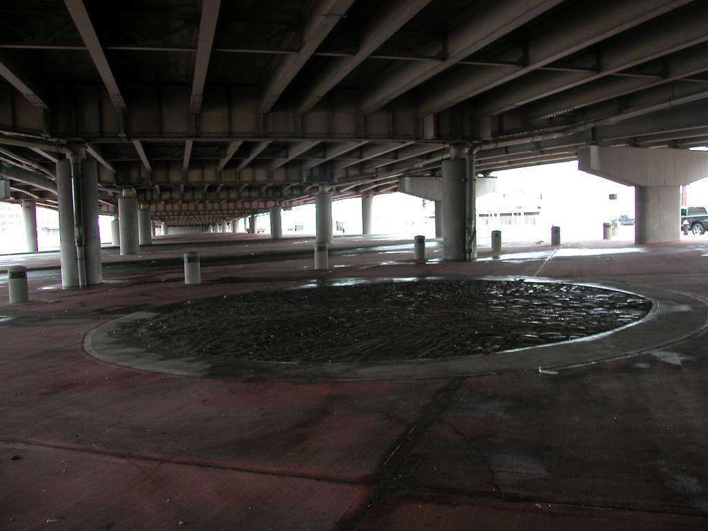
The architectural pun is clear and lovely: elevated highway construction took down many a historic building in previous decades, and demolition continues today (hence the available brick). Activating the otherwise-bleak space under the highway offers both a way to mitigate its dehumanizing form and the occasion to do a little teaching about the scale of materials and the impact of highways on cities.
Can St. Louis try something similar? At present, even the three-block highway lid — which does nothing to offset the tragic landscape of the elevated lanes — included in Van Valkenburgh’s final plan will take years to build. Some temporary programming in our cavernous under-highway spaces downtown would make what could be a long wait for any changes to I-70 easier to bear.
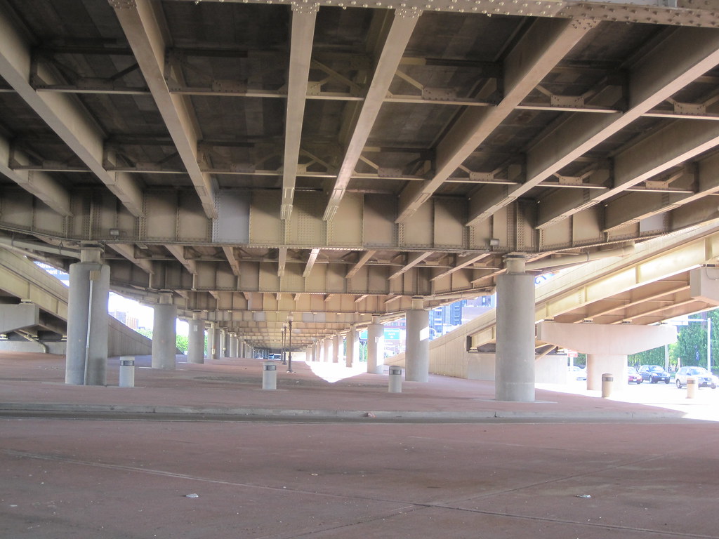
The elevated structure itself is not the worst architecture in St. Louis, either. It is a utilitarian work of steel and concrete — there’s untapped visual potential that we should harness as long as it stands.
by Michael R. Allen
Today, the citizen organization City to River launched its website that presents a thoughtful, creative approach toward building a new Memorial Drive. The analysis and imagery of the website come at a wonderful moment, right after the Framing a Modern Masterpiece design competition jury has chosen the nine design teams that will create full entries. May the design teams spend time contemplating the City to River proposal, and may the design competition’s sponsors keep the door open for any team that may wish to embrace a radical way to renew the riverfront connection.
by Michael R. Allen
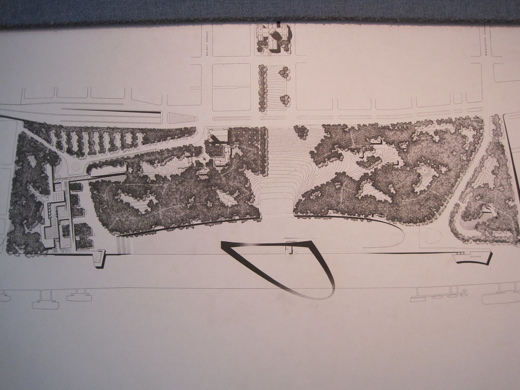 This snapshot from the Old Courthouse exhibit on the original Jefferson National Expansion Memorial design competition shows the winning site plan submitted by architect Eero Saarinen and landscape architect Dan Kiley in 1948. Below is an illustrated version of that plan.
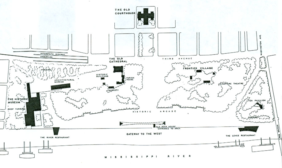 This site plan was not built due to programmatic changes by the architects and the National Park Service (NPS). Obstacles that forced site changes included the agreement between NPS and the Terminal Railroad Association to retain the railroad tracks through the site and the need to elevate I-70 over the tunnel at the Eads Bridge. The original design placed the Arch closer to the river in anticipation of railroad removal, and placed the interstate in a tunnel (shown at top) with a Third Avenue at grade above not unlike the one envisioned by advocates today.
Other changes from the original plan:
Kiley reoriented the layout of the Memorial for a nearly symmetrical plan.
The Campfire Theater was a programmatic requirement of all national parks when the competition was held, but dropped before completion of the Memorial.
Restaurants perched over the riverfront were never built due to the railroad issue. The tunnel required high flood walls that changed the east end of the site that was originally supposed to slope down to meet the levee.
The designers and NPS abandoned plans for an architectural museum on the grounds and placed the “Historic Museum” under ground (the Museum of Westward Expansion).
The designers and NPS abandoned plans for a “frontier village” of reconstructed French Colonial buildings in the northwest part of the site, as well as a group of such buildings around the Old Cathedral.
Entrance to the Arch trams would have been through the reconstructed Old Rock House, shown here between the Arch legs.
The park would have extended all of the way north to the Eads Bridge.
The final landscape work at the Memorial took place in 1982, nearly forty years after the selection of the plan by Saarinen and Kiley. Congressional funding delays are largely responsible for the slow implementation. The Gateway Arch was completed in 1965, after Saarinen’s death. This slow pace of development of one of the nation’s grandest integrated works of modern landscape and architecture no doubt was frustrating, but the result was worth the wait.
Preservation of the relatively young landscape is integral to the current design competition. Still, some of the early ideas of Saarinen and Kiley may be worth contemplation by designers in the current competition. Part of the Memorial enjoys the protection of the nation’s highest level of historic designation, that of the National Historic Landmark. The rest does not. That is not an invitation to alter the landscape, but a potential window for sensitive changes.
Any changes made will be interpretive, and interpreting what is authentic about the landscape is a huge challenge. Architects by nature wish to transform places, and that inclination must be tempered by understanding of Saarinen and Kiley’s plan and its evolution. That’s why the competition requires teams to include someone who understands federal preservation laws — laws that are not prohibitions on change but guiding restrictions.
Certainly, there are two parts of the Memorial that developed due to utilitarian need rather than architectural inspiration — the north and south nodes, where the hulking parking garage and the south maintenance building stand. The maintenance building and the parking garage should be moved off of the grounds, and those sites thrown open to new purposes. Many of us advised Senator John Danforth that should he wish to build a museum at either site, he would have faced little serious opposition. In fact, the south end was where Saarinen and Kiley placed their main museum building in the first plan. Removal of the garage would allow for another intriguing change — removal of the too-wide and underused extension of Washington Avenue on the north side of the Memorial.
Many of the needed changes that sponsors of the design competition seek — better connections, stronger link to river and programmatic venues that attract visitors — are in the original plan. Saarinen and Kiley’s original plan would have made moot any future design competition focused on activation and connectivity.
The inclusion of an architectural museum was prescient, given today’s St. Louis Building Arts Foundation effort. Retention of some sense of the historic riverfront buildings is in keeping with later preservation philosophy that holds that total destruction is never desirable, even in large-scale renewal. Most of all, the designers blended the landscape into the city by bridging the interstate and drawing the Memorial straight into the north riverfront we now call Laclede’s Landing. Eero Saarinen and Dan Kiley left a blueprint for a connected, active Memorial that the current design competition may realize. That blueprint was bestowed with genius and care for the site’s designed beauty. Before designers attempt to rise to that level of genius, they should take a look at the original winning entry.
by Michael R. Allen
The New Year will bring to St. Louis an international architectural competition centered on the Jefferson National Expansion Memorial. The only other such competition to take place in St. Louis also concerned the Memorial; in 1948, a competition selected for the Memorial the designed landscape of architect Eero Saarinen and landscape architect Dan Kiley. That selection gave a declining American river city a triumphant architectural boost and a place in postwar architectural history. The Gateway Arch designed by Saarinen became the internationally-recognized symbol of the city.
Will the new design competition lead to the implementation of a design as boldly modern as the Arch? Probably not. After all, the program for the competition is realization of the National Park Service’s new General Management Plan (GMP) for the Memorial. That plan’s preferred alternative is not a blueprint for radical upheaval of a significant landscape but a corrective program for finding remedies to that landscape’s flaws. The new CityArchRiver 2015 Foundation, spearheaded by attorney Walter Metcalfe, Mayor Francis Slay, Memorial Superintendent Tom Bradley and national parks advocate Lynn McClure, is sponsoring the competition and raising money for implementation of the winning entry.
The competition thus wisely avoids a fruitless effort to construct a parallel icon near the Arch. The architectural genius of the Gateway Arch is elegant and unparalleled. Few contemporary architects — or even starchitects with their tedious “signature” touches — could match Saarinen’s vision. Likewise, the Kiley landscape is a masterpiece. To attempt to add to the Memorial design through iconic design is folly. John Danforth’s museum proposal was fueled by the incorrect assumption that any large new building on the Memorial grounds could be anything other than pretty clutter.
Still, the design competition is a clarion call for vision of a different kind. The GMP acknowledges the spatial obstacles to pedestrian access to the Memorial. In the GMP, there is discussion about the terrible infrastructure on the west and south sides of the Memorial that make pedestrian access difficult. The GMP discusses the moribund riverfront, the dormant east riverfront and other things that make the Memorial grounds a very divine landscape surrounded by an ugly cityscape and divided from urban vitality.
The design competition responds to the GMP by calling for radical reconceptualizing of the cityscape on both sides of the river that frame the Arch grounds. The subtitle of the competition is “Framing a Modern Masterpiece,” indicating the challenge ahead: visionary urban place-making around a magnificent landscape that cuts across the boundaries of many government entities.
This competition thus is as much about politics as design. Mayor Francis Slay and Senator Claire McCaskill are deeply involved in the process. There is little doubt that the competition’s fast track — completion of improvements is slated for 2015 — is driven by political concern rather than interest in truly transformative planning. In an interview, I asked competition manager Don Stastny of Stastny Brun if he had ever been involved in any design competition that had a time line of less than six years between the start of the competition and the projected completion of the design. He said that he had not, save a State Department competition for the destroyed Nairobi embassy.
There is a strong tension between the frank analysis offered by the National Park Service in the GMP and the “get it done” attitude of elected officials. Perhaps that tension is productive in a city that lacks any effective planning ordinance or agency. The National Park Service is playing the catalytic role that a city planning agency should already have done. On the other hand, without the competition’s ambitious pace, good ideas might get lost or watered down through slow implementation. The competition process cuts through parochial politics by forcing St. Louis, East St. Louis, Missouri and Illinois to work together and implement solutions that are not neatly confined to parochial politics of appropriations.
Still, there is no need to have everything done by 2015. I like that early date as a spur to slow-moving local governments. However, I am afraid that date could preclude consideration of larger projects needed for connectivity. The competition cannot produce anything as great as the Memorial, but it need not be reigned in by a fixed, arbitrary timeline. After all, Kiley and Saarinen’s plan was selected in 1948 but not fully completed until 1982.
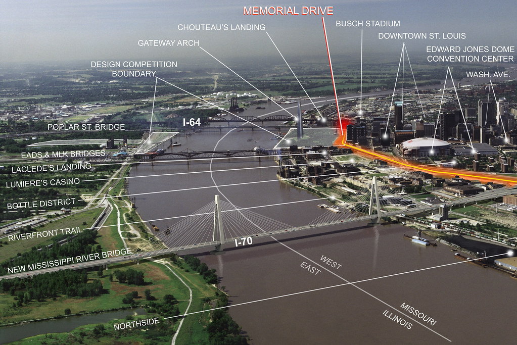
Boundaries
 The boundaries of the competition are exciting, as the map above shows. There are several notable inclusions:
Highway Removal
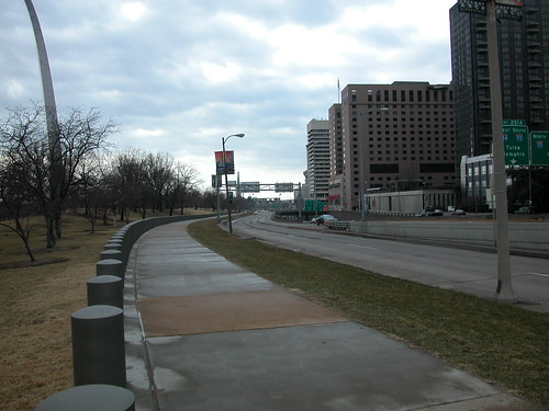
 If there has ever been the right time to consider removal of the depressed and elevated lanes, it is now. There is a great converegence between the design competition — where thinking big is encouraged, and reweaving urban fabric is the foundation for the program — and the 2016 opening of the new Mississippi River Bridge that will carry I-70 out of downtown forever. While the end dates of these projects don’t align perfectly, they are too close to leave unexamined. Highway removal need not be underway in 2015 for the ribbon-cutting; if the competition jury endorses any plan for highway removal, the region will have made major progress.
 Obviously, the impact of the new bridge on traffic would need to be studied before removal could be planned. The replacement of I-70 should not be set in stone, since a wide boulevard could be as pedestrian-unfriendly as the current I-70/Memorial Drive configuration. Those two considerations are perfect fodder for a team of design professionals to engage. While we have the world’s best architects working on solutions for the Memorial’s connection to the rest of the city, we would be foolish to not encourage them to study one of downtown’s biggest problems.
We have great leadership in the Memorial’s Superintendent Bradley. Tom Bradley has been a patient, thoughtful and progressive player who has managed to channel converging political forces into a positive direction. Bradley weathered the Danforth museum idea, which did nothing to address the real planning issues of the Memorial, and forced normally complacent local leaders into action that has the potential to truly transform downtown. Stastny likewise should be a great manager, since his philosophy is that his clients must determine the choice to have a competition on their own. He’s not a salesman, but an astute facilitator.
A successful competition will consider every entry on its merits, and its jurors will have the courage to endorse the best plan no matter what its political implications may be. We may never again see another international design competition in St. Louis. We must be as wise as our ancestors — nay, wiser.
This week St. Louisan extraordinaire Jeff Vines discovered an online cache of 120 photographs of St. Louis Public Service Company trolley cars taken between 1954 and 1961. A few photographs from the 1980s are included.
The images of the cars in their vintage red, white and tan color scheme are fabulous. Yet the photographs also capture views of the city long lost, change or, in a few cases, preserved. The old Grand Avenue viaduct, its replacement soon to be replaced, features in many of the photographs in use adn under demolition. Other locations include the South Broadway car barn (now site of Carnahan Middle School), the Midtown skyline (remarkably unchanged), Maplewood, University City and Flynn Park, Washington Avenue from the Eads Bridge street car turn-around to 15th Street, rural Creve Couer, downtown St. Charles, and McKnight Road.
The photographs of the vicinity of the Eads Bridge and Washington Avenue include shots of the piers for the modern elevated lanes of I-70, now seen as likely to be removed in most of our life times.
by Michael R. Allen
 Six Case Studies in Freeway Removal is a an excellent overview of successful efforts to eliminate interstate highways in urban areas that created barriers. While there are examples from large cities like San Francisco, Toronto and Vancouver where one might expect progressive government, there are also studies from Milwaukee and Chattanooga where advocates for reconnecting the urban fabric faced greater odds.
There are constant themes in each project profiled in Six Case Studies in Freeway Removal: beautification and functionality were major goals of cities that removed freeways or freeway sections, spillover traffic was absorbed without major new congestion and freeway removal almost always lead to higher property values. St. Louis leaders contemplating the mess at the western edge of the Gateway Arch grounds ought to consider the findings of this study, and commission one aimed at the particular local problem that I-70 poses.
One of my first reactions to the case studies from other cities is that the I-70 problem is not that big. Taking the logical dimension of removal from the Poplar Street Bridge on the south to Cass Avenue on the north, one sees that we don’t have as long or as vital a stretch of highway as other cities removed. What we will have in a few years, after the new river bridge opens, is a redundant second section of an interstate highway that disrupts the connection between downtown and the riverfront.
Is St. Louis ready to join the ranks of the cities that have found the leadership needed to think big? A few months ago, I might have been pessimistic. Now, I see that City Hall and many leaders are willing to take a major urban planning risk with McEagle Properties’ NorthSide project. Putting aside the details of NorthSide, that project takes a leap of faith — the scope is vast, the cost great and the potential for changing the central city tremendous. Part of the project even involves removing interstate highway infrastructure, the 22nd Street ramps connecting to Interstate 64. The project aims to capture southbound I-70 exit traffic and send it onto Tucker Boulevard, not eastward toward Memorial Drive. That flow could lessen traffic volume on the old I-70 and Memorial Drive.
 Is there a connection between NorthSide and removal of I-70 downtown? Not yeat, but there is a binding tendency in each project: big-picture economic development planning. While NorthSide’s proponent is its developer, proponents of removing I-70 are citizens who see tremendous development opportunity along a human-scaled street. The removal of I-70 would weave the riverfront back into downtown, and it would create acres of land ripe for transformative downtown development. Like NorthSide, the process could take decades, but the results would be redevelopment on a scale beyond our wildest dreams. Add in the Chouteau Greenway project, and in thirty years Downtown could be ringed not by bleak interstate, asphalt parking and towing lots and vacant buildings but by connections to exciting new projects and renewed old neighborhoods.
Other cities took the leap of faith needed to set this level of vision into motion. Will St. Louis?
by Michael R. Allen
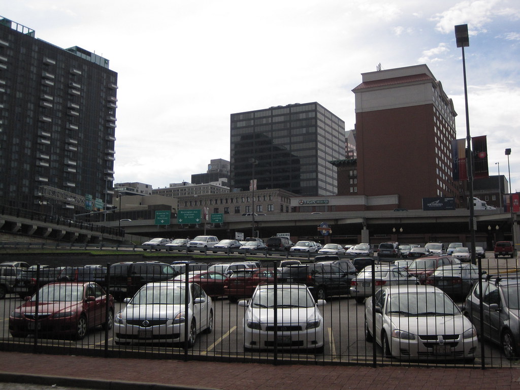
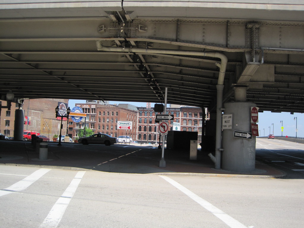
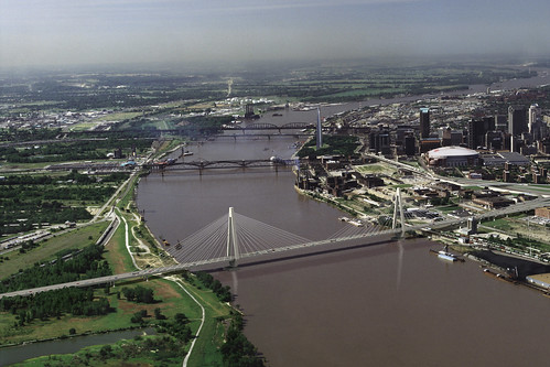
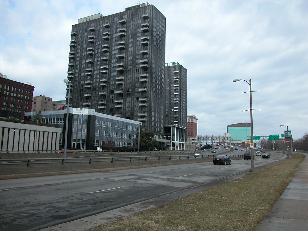
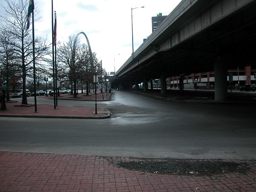
Yesterday evening I happened to be driving south on I-70 through downtown St. Louis. Often this drive passes by and barely registers in my mind, but this time I could not help but vividly see something — something that was not there. As I rode the elevated lanes that divide and conquer the area between downtown and the riverfront, I looked south at the point where 4th Street comes close to I-70. There, the highway and the street form a wedge shape filled by overabundant sidewalk space, a parking lot and the Hampton Inn.

I imagined that instead of being elevated ahead of a descent, I was driving at grade from Cass Avenue all of the way to the Poplar Street Bridge. The highway became an urban thoroughfare allowing for easy local access and great views. I could foresee stopping at traffic lights as pedestrians walked from the casino over to restaurants on Washington Avenue, or from downtown apartments to the river for a stroll. Instead of a gravel lot, I saw a completed Bottle District with modern mid-rise residential buildings. Lumiere Place presented an attractive face to downtown.
Straight ahead, I did not see the weary concrete sidewalks and parking lot ahead of the Hampton Inn, but a new flatiron office building with a fountain in the middle of the plaza where traffic between the boulevard merged with Fourth Street. The sensation was akin to the view of downtown Chicago offered at the point near the Drake Hotel where Lake Shore Drive meets the north end of Michigan Avenue. That view always gives me a giddy feeling, because the essence of the entire urban density of Chicago seems to come into view there. The options there are staying on Lake Shore Drive for the breathtaking view of the lake or turning off onto the Magnificent Mile. There is no mediocrity in sight.
Yesterday, I saw a similar picture. I could make a right turn and veer off into the excitement of downtown, lured by the refined architecture of the Missouri Athletic Club, or head straight for that section of downtown that is right at the Gateway Arch. Either way I was going to see our urban core at its best. When I was right at the Arch, instead of dangerously looking up through aging concrete infrastructure, I caught a red light and had at least 20 seconds to take in the glistening sheen of the Arch skin reflecting the golden sunset.
Landmarks Association of St. Louis submitted the following comment on the draft General Management Plan for the Jefferson National Expansion Memorial to the National Park Service:
Landmarks Association of St. Louis, Inc. was founded in 1959 with a mission to “promote, preserve and enhance St. Louis’ architectural heritage and encourage sound planning and good contemporary design.” Both facets of our mission statement compel our comment on the draft General Management Plan (GMP) for the Jefferson National Expansion Memorial (JNEM).
Generally, we find that the GMP includes many strong and useful ideas for a future design program that would preserve the unique modern landscape of the Arch grounds while transforming the connections between the landscape and surrounding urban fabric. Landmarks Association commends the National Park Service (NPS) on recognizing the extent to which the condition of the existing connections are a hindrance to both JNEM and downtown St. Louis. We are supportive of many of the ideas common to all of the Alternatives under consideration, including streetscape unification plans, improvements to interpretive programming and museum exhibits, increased visitor activities, improved pedestrian access and encouragement of development of the east riverfront.
True to our mission, Landmarks Association makes the following recommendations for the final GMP to clarify preservation of the Arch grounds and expand the range of possible options for improving connectivity:
1. The NPS should allow removal of I-70 in the GMP. The presence of I-70 at the western edge of the Arch grounds is the biggest obstacle to pedestrian access, at the Old Courthouse, Washington Avenue and other major entrance points. With the projected opening in 2012 of a new Mississippi River Bridge carrying I-70, the elevated and depressed lanes that sever the Arch grounds from downtown will no longer be necessary interstate lanes. One possibility at that time would be exploring a merger of I-70 and Memorial Drive into an attractive at-grade boulevard that would carry through traffic while creating a softer, pedestrian-friendly western edge to the Arch grounds. This idea could be explored through a design competition and traffic study. The current GMP alternatives would not allow exploration of this idea. The final GMP should include removal of I-70 within the parameters of a design competition.
2. The GMP should contain other options for a design competition. The NPS has included in the GMP alternatives a detailed and comprehensive understanding of the problems and opportunities of improved access to the Arch grounds. The preferred alternative calls for a major design competition for resolution of these issues, but we think that NPS has already created a framework for practical, incremental solutions. We think that a major design competition has the potential to generate design ideas incompatible with a landscape designated as a National Historic Landmark containing an iconic work of modern architecture. Division of the competition into phases based on specific areas where there are access problems could allow for an incremental implementation that resolves design problems faster and preserves the integrity of the JNEM landscape. An incremental approach would also allow time to build needed alliances with public and private entities that control infrastructure crucial to improved access but not contained within JNEM. The GMP should not bind the process to a single major design competition.
3. Site history must be part of program expansion. The St. Louis riverfront was the entry point into the city for nearly 200 years. The riverfront’s architectural, commercial and cultural history is key to understanding the significance of the JNEM site, and current interpretive program could be expanded to better tell that story. Architectural elements and artifacts from the riverfront could be prominently displayed in existing or new JNEM cultural facilities or made part of new construction.
4. The GMP should improve access and connections at all sides of the Arch grounds. The current GMP alternatives are weighted toward improvement of access at the western side of the grounds. Improved access at both the south and north ends of the grounds could forge connections between JNEM and the Chouteau’s Landing and Laclede’s Landing areas, both of whose development have suffered from circulation problems. The north end of the Arch grounds are adjacent to the historic Eads Bridge and its MetroLink station, but currently access and visibility of those resources from JNEM is impaired. The central riverfront is unattractive and lacks adequate pedestrian access. We strongly feel that preservation of the cobblestone levee is crucial to the integrity of the riverfront, but feel that parking is an inappropriate use of that levee. While not directly under NPS control, the riverfront offers possibilities for destination-type activity ranging from heritage education to restaurants or other venues on boats and moored structures. Improving activity on the levee itself is key to drawing JNEM visitors to the river itself.
by Michael R. Allen
Robert W. Duffy’s article “To connect the Arch to the city (and the river), find the middle” in the Beacon broadcasts the good news from this weekend: a group of concerned citizens forged a coalition to address the issue of reconnecting downtown St. Louis to the Arch grounds and the riverfront, and vice versa.
The meeting and consensus for forward movement potentially could tie together many disparate strands of thinking:
All of these ideas and plans are in various stages of reality. Most have yet to move beyond talking points and renderings. Isn’t the moment ripe to link these plans together through a master vision for the central St. Louis riverfront? The people who came together on Saturday think so, and will spend the next few months trying to link the many ideas for making the city’s front entrance a beautiful one.