Categories
Events South St. Louis Tower Grove East

Rehabbers Tour of Tower Grove East Tomorrow

Please come on this Saturday’s Rehabbers Club tour as we visit two Works in Progress buildings in the Tower Grove East neighborhood.

9:30 a.m.: Tour site #1: 3434 Humphrey St. 63118

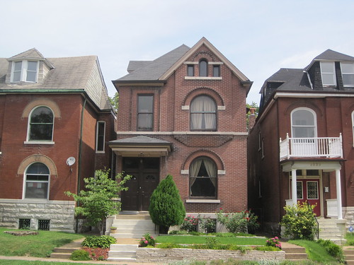
Patty Maher is the owner/developer of this all brick home that is for sale for $240,000. She is almost done rehabbing the building and has used green rehabbing techniques and state historic tax credits. The building recently won DeSales Community Housing Corporation’s “Gold Brick Award” in recognition of high quality work happening here.

This spacious home will have four bedrooms, three full bathrooms and an office. Universal design techniques have been applied on the first floor which includes a bathroom and bedroom. Come learn about the work the Patty has done to modernize this beautiful building.

10:30 a.m.: Tour site #2: 2945 Michigan Ave. 63118

David Woodruff and his fiancé Tiffany Ellis purchased their home in May 2009 with the help of a 203K rehabbers loan and realtor Jim Willen.

David searched the city for almost two years to find a property that was roomy, in an emerging neighborhood and what he calls a “livable rehab”. Now, after fourteen months of living in the attic, three general contractors and lots of paint chips, David and Tiffany are still at it, behind pace, but on budget.

The home was built in 1892 as a multi-family residence. David and Tiffany moved stairways and doorways to combine the apartments into a single family home.

David and Tiffany have done their best to re-use and repurpose as much of the home as possible. They’ve drastically improved its energy efficiency by replacing all 22 windows, adding a tankless hot water heater, converting to natural gas, updating the electrical and water lines and will soon add a white painted roof.

Categories
Central West End Downtown Mid-Century Modern Midtown Motels North St. Louis South St. Louis

Motels in the City of St. Louis

by Michael R. Allen

A version of this article first appeared in the Winter 2009 NewsLetter of the St. Louis Chapter of the Society Architectural Historians.

There is ample recognition of the significance of mid-century motels along roadsides across America, where motels used colorful signage and design to beckon to weary Americans enjoying their automotive freedom. Perhaps because of nostalgic idealization of the motor court and the “open road” and perhaps because of the stigma that postwar urban renewal efforts have attained, local history overlooks the significant wave of urban motel construction that took place in St. Louis between 1958 and 1970.

Advertisement for the Bel Air Motel. Note that the front wing does not yet have the third story addition.

The 1958 opening of the Bel Air Motel on Lindell Boulevard renewed the building of lodging in the City of St. Louis while introducing a hotel form new to the city, the motel. St. Louis’ last new hotel before that was the nearby Park Plaza Hotel (1930), a soaring, elegant Art Deco tower built on the cusp of the Great Depression. However, another hotel built before the Depression was more indicative of future trends than the Park Plaza. In 1928, Texas developer and automobile travel enthusiast Percy Tyrell opened the Robert E. Lee Hotel at 205 N. 18th Street in downtown St. Louis (listed in the National Register on February 7, 2007), designed by Kansas City architect Alonzo Gentry. While the 14-story Renaissance Revival hotel was stylistically similar to contemporary hotels, it introduced the chain economy hotel to St. Louis.

Categories
Gate District South St. Louis

Buildings on Chouteau Avenue Will Fall

by Michael R. Allen

Looking southwest along Chouteau Avenue just west of Jefferson Avenue.

Yesterday, the Preservation Board unanimously approved demolition of four buildings on the south side of Chouteau Avenue just west of Jefferson Avenue. Last April, the Board had unanimously denied demolition to owner Crown Mart 40 (See “Preservation Board Spares Chouteau Avenue Buildings; Now What?”, April 30, 2010.) The meager silver lining here is that the Cultural Resources Office, whose staff recommended denial of the permits, gets to approve a landscaping and fencing plan for the site before a demolition plan goes through.

Landmarks Association placed the buildings on its 2010 Most Endangered Places list with the strong statement that “the idea that rows of historic buildings can be plowed under as collateral damage in a short-term cat and mouse game between business competitors, is treated with the contempt that it deserves.” However not one person testified against demolition yesterday, nor did any person send a letter. two Gate District residents and a neighboring business owner either testified or sent letters supporting demolition, and Alderwoman Kacie Starr Triplett (D-6th) made a personal appearance supporting demolition.

The larger issue for time-ravaged Chouteau Avenue is that there is precious little historic context left, and many vacant lots. While these buildings are lost, the character of the street will remain inconsistent and graceless. Perhaps Chouteau between Broadway and Grand Avenue needs a zoning overlay to guide future development. A major artery running alongside densely-populated neighborhoods south of downtown ought to look a lot better that Chouteau does.

Categories
Collapse Gate District South St. Louis

Lafayette Avenue Row House Collapsed

by Michael R. Allen

2804 Lafayette Avenue in November 2010.
2804 Lafayette Avenue today.

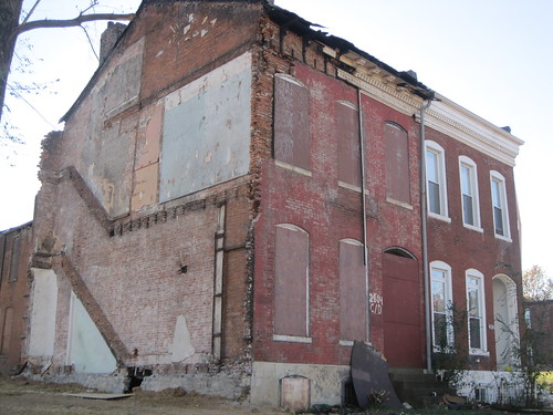
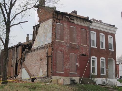
As I feared, the row house at 2804 Lafayette Avenue was destabilized by last year’s demolition of its party-wall neighbor and has substantially collapsed. (See “Two for One on Lafayette Avenue”, November 16, 2010.) The forthcoming demolition will leave just one of three connected dwellings standing — hopefully in sound condition.

Categories
Benton Park Carondelet Cherokee Street Marine Villa North St. Louis Pruitt Igoe South St. Louis

St. Louis Mythory Tour

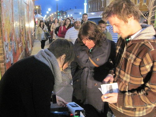
Emily Hemeyer helps two people assemble their zines at the Mythory Tour.

On Friday, as part of the epic Southern Graphics Council (SGC) Convention night on Cherokee Street, the St. Louis Mythory Tour made its debut. An expanded version will return soon, as will a new edition of the ‘zine guidebook, printed in a limited edition of 70 for Friday.

St Louis Mythory Tour
a collaborative tour and zine making workshop
by Emily Hemeyer & Michael R. Allen
May 12th, 2011. 6-9pm. Cherokee ReAL Garden. Cherokee Street. St Louis, MO

“[M]yth is speech stolen and restored.”
-Roland Barthes, Mythologies

ABOUT THE PROJECT

The built environment of St. Louis reveals itself through our observations, often clouded by nostalgia, ideology and comparison. We look around us and see inscriptions of what we imagine St. Louis to be, be that a “red brick mama”, an emergent Rust Belt powerhouse, a faded imperial capital or simply our home. St. Louis offers back its own narrative mythologies, presented through chains of linked sites with collective meanings. We quickly find that the city’s own presentation of itself is as veiled as our own observation. There is no one St. Louis, but there is no one archetypal St. Louisan.

The Mythtory Tour imagines a landscape of accrued building that has been neglected, in physical form and human consciousness. This tour presents one possible mythology of place centered on traditions of construction converging across disparate neighborhoods and many generations in order to show us St. Louis. Whether you can find this city out there is irrelevant, because using this map you will find some city worth your love and respect.


View St. Louis Mythory Tour in a larger map

THE TOUR

1. THEY BUILT WITH EARTH
Sugarloaf Mound, 4420 Ohio Street

2. THEY BUILT WITH STONE
Stone House, 124 E. Steins Street

3. THEY BUILT TO PRODUCE
Lemp Brewery, southeast corner of Cherokee & Lemp streets

4. THEY BUILT IN THE AIR
Pruitt-Igoe Site, Southeast Corner of Cass and Jefferson Avenues

5. THEY BUILT FOR THE FUTURE
Kingshighway Viaduct, Kingshighway Boulevard Between Vandeventer and Shaw
Avenues

6. THEY BUILT UNDERGROUND
Cherokee Cave, Under Cherokee Street at DeMenil Place

7. THEY BUILT ON THE WATER
U.S.S. Inaugural, Foot of Rutger Street

(Full descriptions and photographs of each location are available in the guidebook. Those interested in ordering a copy can contact Michael Allen at michael@preservationresearch.com.)

Categories
Gravois Park Infrastructure South St. Louis

Brick Alley Restoration Underway in Gravois Park

by Michael R. Allen

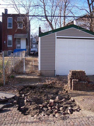
Recently I wrote about two lovely intact brick alleys in the St. Louis Place neighborhood on the north side (see “St. Louis Place: Sidewalk Plaques and Brick Alleys”, February 11). After publishing that post, I learned that there is a pilot program underway to restore 17 brick alleys in two of the city’s south side historic districts, the Gravois-Jefferson Historic Streetcar Suburb District and the Benton Park Historic District. Some work began in December in Gravois Park, and more will start when weather is consistently dry. Work will be completed by August 10, 2011.

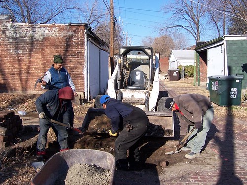
A crew working in December 2010 on brick removal in the alley between the 3500 blocks of Louisana and Tennessee Avenues. Photograph by Eric Bothe.

When alderpeople put in requests for allocation of the city’s American Recovery and Reinvestment Act funds, Alderman Craig Schmid (D-20th) successfully applied for $975,000 to restore and retain historic brick alleys in the historic districts of his ward. The city’s Department of Streets stopped repairing brick alleys in 1978. Subsequently, many miles of brick alleys — which are durable, made from long-lasting brick, easy to repair and moderately water-permeable — have been paved over with asphalt that comes from a nonrenewable source, is not water permeable and is expensive and difficult to repair. Paved brick alleys typically have problems with settling that new paving only compounds. The city fills depressions in brick alleys that eventually sink again, and finds itself having to pave and repave alleys that could have simply been restored. Asphalt paving destroys the integrity of paver bricks, so that even when asphalt surface material is removed the alleys cannot be restored. The practice is unsustainable and expensive.

Removing bricks in the alley between the 3500 blocks of Louisiana and Tennessee avenues. Photograph by Eric Bothe.

Meanwhile, the city no longer repairs existing brick alleys. If residents don’t want asphalt, they won’t get any repairs. Also some aldermen use allocations of paving to pave brick alleys with no problems in order to avoid having to return allocations. Schmid has wanted to retain brick alleys for awhile, but could not use existing money to do so. The Department of Streets needs to change its brick alley policy. Meanwhile, the 20th Ward is the first to experiment with restoring brick alleys using a one-time grant of federal stimulus money.

The good news is that federal stimulus money is funding a small but significant project that implements a sustainable approach to retaining brick alley paving. The project fits the goals of the Obama administration in encouraging green practices through federal spending, but it still leaves permanent policy changes up to the city of St. Louis.

Categories
Benton Park West Demolition LRA South St. Louis

Iowa Avenue House’s Days Are Numbered

by Michael R. Allen

Last year, the Community Development Administration issued a “last chance” call for a proposal to rehabilitate the vacant house at 3244 Iowa Avenue in Benton Park West, owned by the city’s Land Reutilization Authority. (See “Last Chance for 3244 Iowa Street” from May 9, 2010.) A few weeks later, Landmarks Association of St. Louis placed the beleaguered building in its annual Most Endangered Places list.

The house at 3244 Iowa Avenue as it was in early May 2010.

Yet no one took the last chance, and January 12 the city applied for a demolition permit for the small house. Since the house is a contributing resource to the Gravois-Jefferson Historic Streetcar Suburb District, the permit will require approval from the Cultural Resources Office.

Categories
Gate District Schools SLPS South St. Louis

More on Hodgen School

by Michael R. Allen

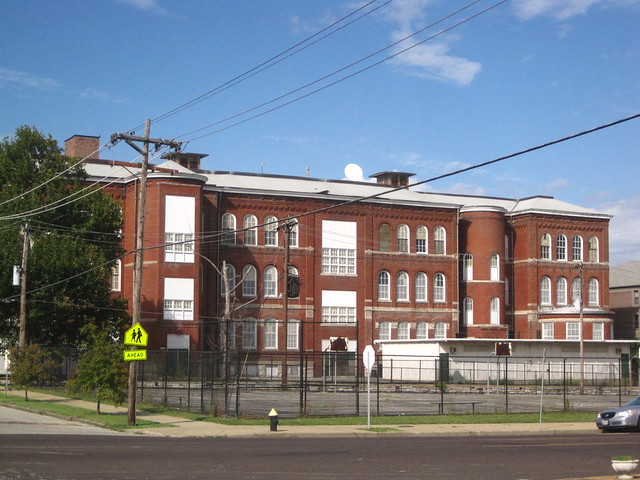
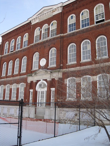
On Thursday, the St. Louis Public Schools announced plans to demolish historic Hodgen School, one of the district’s few remaining buildings that pre-date the tenure of celebrated school architect William B. Ittner.  Hodgen’s central section was designed by Otto J. Wilhelmi and built in 1884.  Wilhelmi served as School Board Architect from January 1883 through January 1886, at a time when architects were elected by the school board in often-contentious elections.  The school was expanded in 1894 and 1909.  Later, a temporary building was built to the north, but it was replaced by the “new” Hodgen School that opened in 2000.  After Hodgen was renovated in the 1990s, the district closed the old building in 2003.

Now the district wants to tear it down for a new playground and parking lot.  The plan seems less like a necessary (or even wise) proposal than as an easy way to get rid of an unwanted building.  Examine the site for yourself on Google Maps and look at the folly of demolition here.


View Larger Map

Hodgen is located in a strange pocket of the Gate District where many streets are closed or simply do not go through. Hodgen faces Henrietta Avenue, but Henrietta is closed in front to provide space for a playground. A large, multi-story senior citizen apartment building is located on to the east on dead-end Henrietta. Across the street is a senior center. The apartment building generates little parking demand, and the senior center has a surface lot. There are potentially plenty of on-street spots on Henrietta that the school could utilize.

To the south of Henrietta west of Ohio on Lafayette Avenue is the shop and yard of Architectural Artifacts, Inc., owned by salvager Bruce Gerrie. To the east of Ohio on Lafayette is another shop and storage yard owned by Bob Cassilly. Further east is the moribund Foodland site, a gas station and a Holiday Inn Express with its own parking lot.

Most striking among the bizarre condition of the current site is the presence of Eads Park, a city park with perversely little street frontage. Just west of the new Hodgen School is a large arsenal of tennis courts that are underutilized — likely because they are invisible to the public. Utilizing Eads Park for the playground needs of Hodgen School makes much more sense than demolishing old Hodgen.

I should point out that Joe Frank wrote about this area with prescient concern back in July 2005 in a blog post entitled “The Destruction of the Urban Environment” (reprinted on the old Ecology of Absence website). When Frank found Henrietta Avenue closed in front of old Hodgen School, he observed that “[t]his makes the old building, which I believe was for sale, significantly less marketable, since its original front entrance no longer has street access.”
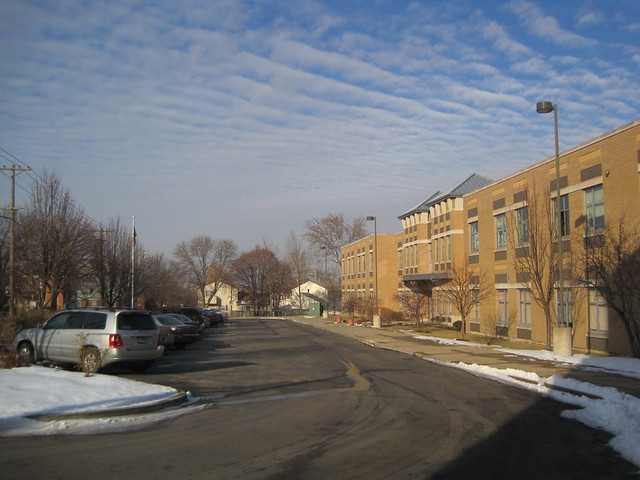
The front lawn of the new Hodgen School, shown above, is mostly a surface parking lot. That fact is a reminder that most students don’t walk to classes here, but it takes care of some of the needs. There is a second lot on the east side, plus parking on Henrietta. Parking on California is not allowed on the east side.

The view of stately old Hodgen school front the east shows that school employees park at the dead end of Henrietta.
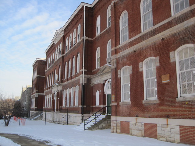
Of course, as Joe Frank stated over five years ago, the street closure is not a helpful factor for selling Hodgen. However, neither is the school district’s bureaucratic mindset that cannot separate by-the-numbers calculations of parking and playground needs from creative design strategies. Besides, the district ought to consider the economics of the situation: the old Hodgen School was listed for sale at $1 million, and building a playground in Eads Park while better using existing parking are options that would cost nothing for land acquisition. Factor the cost of demolition, and the St. Louis Public Schools could be choosing the most costly plan.
Categories
Gate District Schools SLPS South St. Louis

SLPS Plans to Demolish Historic Hodgen School

by Michael R. Allen

Hodgen School in 2009.

In August, voters approved Proposition S to raise $150 million for capital improvements in the St. Louis Public Schools system. Not once did the district tell voters that they were voting to demolish historic schools — but some of the money will demolish at least one, historic Hodgen School on California Avenue in the Gate District. Completed in 1884, Hodgen School is one of the oldest surviving schools in the district. Hodgen was designed by German-American architect Otto J. Wilhelmi. The school building was closed a few years ago when a replacement building was built to the north.

According to an article in today’s St. Louis Post-Dispatch, Hodgen will be demolished to create a parking lot and playground for the current Hodgen School building at 1616 California. The school already has a playground in space between the old and new buildings.

In September, I wrote about a row house demolition just one block southwest of Hodgen School (see “Row House on Lafayette Avenue Slated for Demolition”, September 10, 2010). Little did I suspect that an even bigger loss of context was in the works. That’s because I assumed that Proposition S was going to pay for what its proponents told me it was paying for: improvements that made the quality of education better, not easier parking for teachers and parents.

SLPS had Hodgen listed for sale through Hilliker Corporation, and a sales brochure is still available on the Hilliker site. The brochure touts “extensive renovation in the 1990s” — renovations paid for by our tax dollars in a previous SLPS capital improvements campaign. That sort of wasteful duplication of expenditures is exactly what the current district management has tried strenuously to avoid, so the plan to demolish Hodgen is baffling.

ADDITION: I should point out that the city’s preservation ordinance specifically exempts property of the St. Louis Public Schools, so neither the Cultural Resources Office nor the Preservation Board will have jurisdiction over the the demolition permit. Authority rests with SLPS and its Special Administrative Board. I’ve posted contact information in the comments section.

Categories
Fox Park Local Historic District South St. Louis

Final Approval of Fox Park Local Historic District Expansion Near

by Michael R. Allen

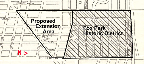
Yesterday the Board of Alderman approved on second reading the ordinance that expands the boundaries of the Fox Park Local Historic District to include eighteen blocks at the southern end of the neighborhood. Included in the expansion, shown on the map here, is St. Francis DeSales Roman Catholic Church.

The Board will take votes on both the third and final readings, but the most important hurdles have been cleared and the ordinance should be law soon.

I interviewed Fox Park Neighborhood Association President Ian Simmons about the expansion in May. Read that interview here: “Interview: Why Residents Want the Fox Park Local Historic District Expanded”.

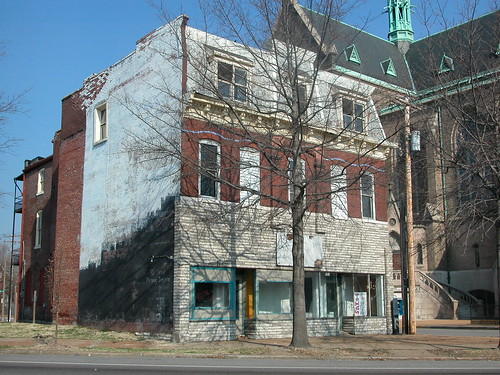
Here are a few images of buildings that now will be protected by the design code of the local district.

On 2800 block of Magnolia Avenue, near California Avenue.
2711-13 Gravois Boulevard, owned by the Archdiocese.
2620 Ohio Avenue.
The flounder house at 2628 Ohio Avenue.
The north face of the 2800 block of Victor Avenue.