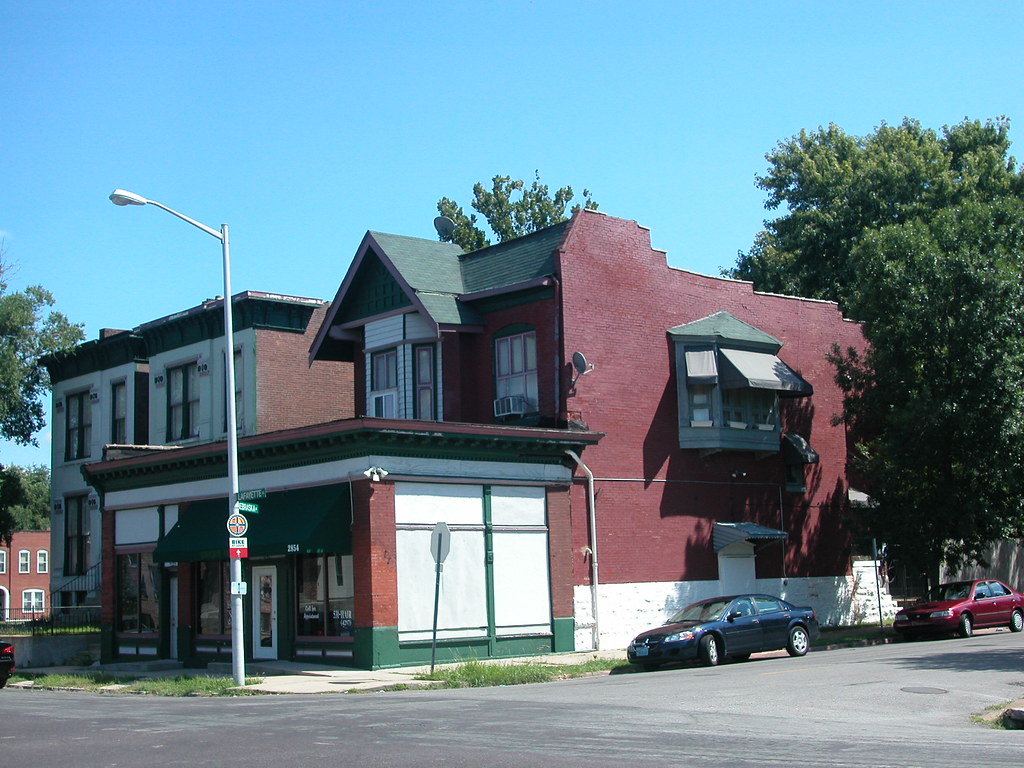
 Storefront additions to residences were very common between 1920 and 1950 between on Lafayette Avenue between Jefferson and Compton in south city. I have written about two others (read them here and here) in this stretch, and neglected to point out a robust corner storefront addition at the southeast corner of Lafayette and Nebraska avenues. On the front of an eclectic Craftsman-inspired house with false mansard and front gable, we have the finest storefront addition on Lafayette. Actually, the addition houses two commercial spaces. Cast iron columns frame generously-glazed traditional storefront openings (which wrap the side), and an intact dentillated tin cornice with a second order of brackets provides a refined crown. Many of these additions bear the programmatic inelegance of their utility. Not this one.
Category: Urbanism
by Michael R. Allen

As I navigate the city, I am always on the lookout for storefront additions to historic homes. Regular readers will recall some recent posts of mine celebrating the sometimes-ungainly but always-intriguing vestiges of a city teeming with commercial life. The example above is located on the 2800 block of Lafayette Avenue just east of one that I chronicled seven months ago (Just Another Vacant Building?, December 21, 2007). That example was one of the prevalent types that stand in front of the parent house.
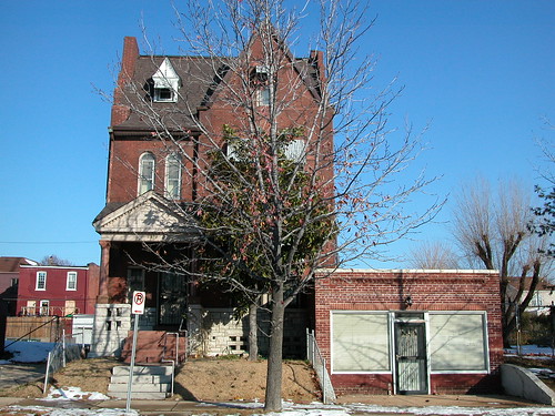
This one here, located at 2819 Lafayette Avenue, is of the gentler type. Built on the side lot of a stately single-family residence, the one-story flat-roofed addition creates more square feet of space on one level than the sort placed directly in front. I’m sure the builder’s concern was with the economy of the structure, but the end result led to an addition that left alone the lovely front elevation of the Romanesque Revival house next door, built in 1893. That move proved fortuitous, as the front elevation retains original its limestone porch, granite details and wooden windows. The addition itself, probably built in the 1930s, is complementary without being dull. Spaced courses of pale brick, a continuous soldier course over the storefront opening and a framed frieze of angled brick offer simple but forceful masonry expression. We still have dozens of these additions left, and each one is a unique compromise between cost and ambition, change and history, old and new. These additions remind us that cities are creatures built for growth, and “historic” architecture is a tangle of buildings — including historic buildings that block other, prettier historic buildings buildings.
by Michael R. Allen

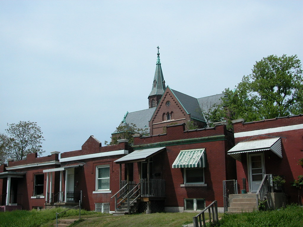
This striking urban view in St. Louis Place includes four one-story, shaped-parapet houses on Sullivan Avenue and the imposing Gothic roof line of St. Augustine’s Church. This is the sort of view that doesn’t happen overnight, and benefits from inherent architectural differences between forms, styles, heights and uses. The church, designed by noted ecclesiastical architect Louis Wessbecher, came first in 1896. Wessbecher also designed the majestic Bethlehem Lutheran Church on Salisbury Avenue in Hyde Park. The church served a largely working-class German parish, and its style is very influenced by North German Gothic architecture. Clearly, the church expresses the highest aspirations of the neighborhood at the turn of the last century. That aspiration has been recognized through both City Landmark and National Register of Historic Places designations.
The houses — part of a longer row between Parnell and Lismore — arrived in the first decade of the twentieth century. In contrast to the church, the houses were designed with great modesty by local builders. The one-story homes are mainly decorated with the shapes of the front parapets and simple tin cornices (some removed). Yet the buildings were sturdy and practical for their residents, offering a single-family home rather than a space in a tenement. The houses are not part of any historic district, locally or nationally. In this view, three of the four houses shown are owned by holding companies controlled by Paul J. McKee, Jr.
Here we have high style and vernacular, a spire reaching upward to the maker and the houses laid out low to the earth of the workaday world. While the contrast is strong, the image tells a very coherent story about the origin of this part of the neighborhood. The tale told about the future is less clear. The long-suppressed parish church has found new use as the home of a mission, but its repair needs seem extensive. The houses sit largely empty and in limbo as part of a development project with no clear parameters or timeline.
The narrative of our past that is embodied in these buildings built itself over time. All it takes is a moment for us to decide that their preservation is a worthy goal.
by Michael R. Allen
The staff of Trailnet’s Healthy and Active Communities Initiative have been blogging away for the last two years. Not reading their work? You should be. The blog provides fresh and insightful information you don’t get in many urban issues blogs — writings about the history of food prices, developments in biodiesel, the problems with the abundance of corn in our diets and so forth. Just as autocentric urban planning is very unhealthy, so is an economic system that keeps nutritious foods off of the shelves of inner city groceries. Trailnet’s staff keep pointing out how these two problems are related, and how the future of every urban area depends on more than just bricks and mortar.
DEVELOPMENT CHALLENGES AND REWARDS
Tuesday, May 13, 2008
7:00 p.m.
The Laurel Sales Office, 625 Washington Avenue
As part of Historic Preservation Week, ReVitalize St. Louis, the Rehabbers Club and Landmarks Association of St. Louis sponsor a panel including Jay Swoboda of EcoUrban Homes and Brady Capital and Stephen Acree of the the Regional Housing and Community Development Alliance, whose work has included many historic rehabilitation projects. Panelists will discuss their careers in St. Louis, the challenges they have faced and the current state of the city’s real estate market. Question and answer session to follow — bring your questions! Free.
UPDATE: Developer Will Liebermann, a developer who has done several projects on and around Cherokee Street, has joined the panel.
by Michael R. Allen
The future is always doubtful to that last historic house on a block in a neighborhood whose primary land use has changed. Neighborhoods just outside of the central business district of American cities that were residential walking neighborhoods typically lost their character in the twentieth century as commercial use crept outward. Large new buildings went up on main thoroughfares, followed by mixed use and apartment buildings on other streets. Old houses became rooming houses, offices and even small factories — until their narrow lots were added to adjacent lots to make sites for larger buildings. Secondary streets often kept much of the old housing stock, but the main streets emerged from second wave development looking more like downtown than ever.
On some blocks, like the one shown above on North Avenue just west of Milwaukee in Chicago, one will find the houses that survived the development waves. Some of these houses stand alone, adjacent to parking lots. Their futures are doubtful, since they stand apart from the historic context that would make their defense likely should a developer want to take the house and the adjacent lot and build a new building. In Chicago, tear-downs like that seem to happen weekly. The new construction is often an insipid four or five story building with street level retail and condominiums above, rendered in a bland minimalist style or a gaudy postmodernist mess.
Other survivors are more fortunate, like this old Romanesque Revival house. When the building to the right went up in the 1910s, the developer didn’t need, want or buy the house. When the building on the left went up, the same story. Neighbors came down, but not the erstwhile little house. The house slipped through both times. With such a small site, and the house being so close to the neighbors, one could guess that the house has escaped demolition. Then again, in urban real estate, nothing is ever certain.
There were years in recent memory when this stretch of North Avenue were devoid of much development interest, and then things changed rapidly. Even if the market is in downturn now, that won’t last forever. Some locations hold inherent value that survives the market’s cycles. Some buildings do too. Is this house one of those now, by virtue of its escape?
The Soil Fails
by Michael R. Allen
Curtis Eller came up with a song title and phrase so haunting to those of us who live in north St. Louis. “After the Soil Fails” is really a song about a vivid dream inhabited by historical figures like William Tecumseh Sherman, but its references to the imagined deaths of New Orleans and Philadelphia invoke the condition of emptying sections of St. Louis.
“One of these days the soil is going to give out,” warns Eller. While the causes of much of the loss of the built environment of north city is more economic, the landscapes left behind are devoid of any clues. To the innocent wanderer, perhaps it seems that the very land on which the city is built is dead. Just as bad soil kills crops, bad land could kill blocks or neighborhoods. The difference is that the infection of farm soil is real, while the infection of our city soil comes from within us, legitimate brown fields notwithstanding. City land is as good for city life as ever. Trouble is, city land’s healthful properties come not from its physical content but from how it’s labeled on maps and valued by builders. An ounce of soil from a lot in St. Louis Place could be as nutrient rich as any found in Clayton, but that has nothing to do with the value of the land it composes.
Hence, the best soil for farming in the region may be in places like the floodplains of St. Charles County, while the better soil for building could be the bedrock-pinned land of north city. We don’t seem to mind this absurdity as continue to build out irresponsibly. If soil affected our settlement patterns as it does planted crops, our soil would have failed awhile ago. Maybe it still will.
Kaskaskia Remains
by Michael R. Allen
The villages of Dozaville (once Goshen) and Kaskaskia, Illinois remain as vestiges of settlement on Kaskasia Island. Dozaville is a complete ghost town, at least officially — it has been legally dissolved for decades. Kaskaskia remains incorporated, although with less than a dozen residents in four households within its boundaries has no real need for civil government. Kaskaskia is one of those places that has achieved zero population growth according to the US Census — a bizarre stasis for a town once of great importance.

Although part of Randolph County in Illinois, the island is west of the Mississippi and accessible only via a bridge from St., Mary’s, Missouri. A shallow channel barely recognizable as a river separates St. Mary’s from the island, suggesting that the land nearly is part of Missouri. On maps, the land seems fully engulfed by Missouri. Most maps don’t even note the channel with water, but merely include a political boundary line. Kaskaskia seems an improbable location for Illinois’s first state capital. Now remote, plagued by low land that constantly floods, and insular, Kaskaskia was once a vital part of early French settlement of the Mississippi River valley. The island was once an attached Illinois peninsula.
In 1673, Louis Joliet and Father Jacques Marquette claimed the Mississippi River valley in this area. In 1675, Marquette visited the site of Kaskaskia and established the mission of the Immaculate Conception. The mission became a church, and the settlement around the mission grew into a village with fur trading and farming as prevalent economic activities. In 1703, Kaskaskia was founded as the second village of European settlers in Illinois. By 1752, the population stood at a relatively robust number of 671 residents.
At the advent of the French and Indian War in 1756, French townspeople built Fort Kaskaskia on a hill east of the town, now across the Mississippi River. Residents destroyed the fort to prevent it from falling into British control when the British won. Many residents fled to Ste. Genevieve after the war. Later, the British built Fort Gage in Kaskaskia but lost the fort to Revolutionary General George Rogers Clark in 1778.
Kaskaskia became Illinois territorial capital in 1804. In 1818, the newly-created State of Illinois chose to retain Kaskaskia for the first state capital, although for only two years. The Emigrant’s Guide of 1818 states that there were 150 houses standing in the village. Growth would not arrive, however, as the village quickly lost the capital to more centrally-located Vandalia. One notable event happened after the loss of the capital: the establishment of the convent and school for the female school Visitation Academy in 1833.
However, the biggest blows to the village’s fortune came with terrible floods in 1844 and 1881. Located at a narrow spot between the Kaskaskia and Mississippi Rivers, the site was vulnerable to the Mississippi’s eastward shift. Eventually, that river pushed over the narrow neck of the peninsula to create the present island. The first flood caused great population loss, and the second flood created the river channel that made the land around Kaskaskia into an island. During the period between the floods, Visitation Academy relocated to the city of St. Louis in 1844. After an 1893 flood, the town relocated to its present location.
In 1993, flood waters again submerged the island and caused residents to flee. Nowadays, the population of Kaskaskia is about 9 and the population of the island is about 93 people. Kaskaskia still retains its street grid, which carves out blocks punctuated by the few remaining buildings.
One of those remaining buildings is the Church of the Immaculate Conception, built in 1882 and moved to its current site in 1894 after the devastating 1893 flood. A church founded by Marquette now meets only on Saturday afternoons — strangely diminished in human size but awesome in the length of its existence. The brick building has managed to survive several floods with its Gothic Revival architecture intact.

A long-time parishioner is profiled in the article found here.
A newer building is the home of the church’s historic bell, gifted by the King of France in 1741 and known as the “Liberty Bell of the West” since the townspeople rang it on July 4, 1778 to celebrate liberation from British rule.
The old school house is interesting, although badly damaged by flooding and alterations to its fenestration. Boarded up, the brick building is missing much of its interior structure although it has gained a new roof since the 1993 flood. Reuse seems unlikely, although someone is performing enough continued maintenance to ensure survival of the old building.
A few frame and brick homes comprise the rest of Kaskaskia. The wide sight lines of the island ensure views of the church spire and school house framed by expanses of fields. Settlement has come full circle for Kaskaskia, but somehow it endures.
by Michael R. Allen
According to an article on the CNN website entitled “Crime scene: foreclosure”, Cleveland’s historic Slavic Village neighborhood is in the nation’s top ZIP code for foreclosures. An estimated 800 buildings sit vacant there. The neighborhood has out-of-control crime, correlated to the foreclosure rate. Houses get stripped within 72 hours of being vacated, and aren’ty worth enough money to justify repair. Police are inattentive, and the city can’t afford to do much trash cleanup or demolition. People flee in droves, leaving those who remain in fear. Lenders continue to foreclose, with little concern about the effects.
This situation sounds a lot like conditions in north St. Louis in the 1960s, 1970s and 1980s. The article’s eerie conclusion reads “as the number of empty lots and abandoned houses grows where houses and residents were once packed in a tight community, there are fewer and fewer neighbors to fight the battle.”
(Thanks to Barbara Manzara for the link.)
Did you know that UMSL is hosting a conference entitled “What is the City?” this Thursday, October 25 and Friday, October 26? The conference examines “urban perspectives in film, fiction, and photography” and is free with advance registration.
Here’s the full description:
The Center for the Humanities invites you to join speakers from around the country and St. Louis in examining urban life in contemporary and historical films, fiction, television, and photography. We will discuss examples from London, Chicago, Sarasota, Paris, Los Angeles, Florence, St. Louis, and small towns. The conference presenters are historians, geographers, photographers, film critics, community activists, literary experts, and writers. Engaging in discussion across many disciplines, they will consider ways artistic images and writings shape how we see our cities and those of others.
The schedule and registration form are here.


