by Christina Carlson
I recently had the opportunity to digitize several photographs for the Preservation Research Office spanning from the 1930s to the 1980s. The photos consisted primarily of pictures of historic buildings and other structures in St. Louis, but also included were snapshots of parades, fairs and local people. Although many of the photos were of great interest– revealing buildings, people and spaces now forgotten — a few in particular caught my attention.

At first glance this snapshot appeared to me as nothing out of the ordinary, simply another picture of the substantial efforts at demolition which took place in mid-century St. Louis. However, on a second look I recognized the iconic nature of this photo. The church in the center of frame is The Basilica of St. Louis, King of France, which sits adjacent to the Gateway Arch ground. I realized that this image captures the moment of destruction for a large swath of the riverfront area which began in 1939 and ended by 1961. Despite the conjecture of many who saw the riverfront area as a vital, ethnically and cultural diverse area, demolition of some of the oldest buildings in St. Louis was approved in 1939. In a twist of irony, much of the Eastern portion of the city was destructed to make way for a memorial to Westward expansion.[1]

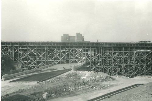
Another photo I noted was one on the opposite end of the spectrum, as it portrayed the construction of the lanes of Interstate 44 where it merges into Interstate 55 south of downtown St. Louis. This image evokes a different moment in the city’s history, one in which it suddenly became much easier for those in the rapidly expanding suburbs to reach downtown, and to leave it. Although the history of suburban development in the post-war years is well known, the story in St. Louis was particularly evident. As the population shifted outward, many buildings within the city were demolished, leaving in their wake parking spaces and empty lots.
Side by side, these two images powerfully convey prominent themes in the history of St. Louis: the destruction of older, more diverse districts and the construction of vast networks of suburbs, supported by the presence of major freeways bypassing downtown. Although there are a variety of themes present in the photographs I digitized – family ties, segregation, religion, wealth, poverty – none were so prevalent as the drastic restructuring of the face of the urban landscape in St. Louis in the middle of the twentieth century.
Christina Carlson is graduate student in History at Southern Illinois University Edwardsville. She recently received a certification in Museum Studies from SIUE, and currently works at the Saint Louis Science Center. Christina served as project intern for Preservation Research Office this summer.
Notes
1. W. Arthur Mehrhoff, The Gateway Arch: Fact and Symbol (Bowling Green: Popular Press ), p. 59.

One reply on “Photographing the Changing Face of St. Louis”
[…] of the connection of Interstates 44 and 55 in St. Louis. Photographer unknown. Source: Preservation Research Office. Share this:TwitterFacebookLike this:LikeBe the first to like this […]
[WORDPRESS HASHCASH] The comment’s server IP (72.233.61.49) doesn’t match the comment’s URL host IP (72.233.2.58) and so is spam.