Categories
Clearance South St. Louis

Across From the Pevely Dairy Plant

by Michael R. Allen

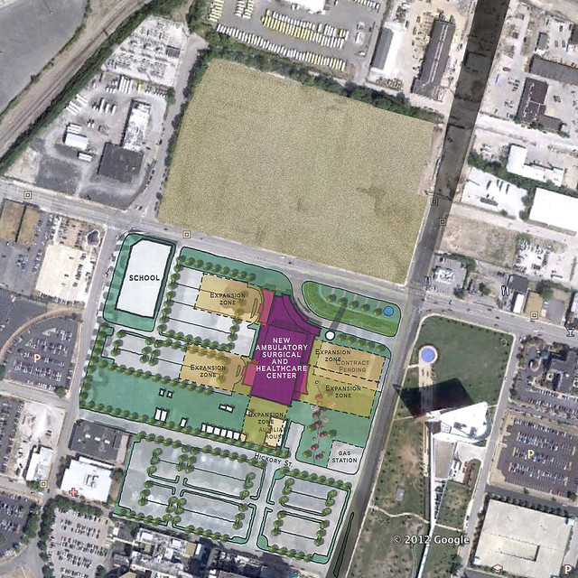
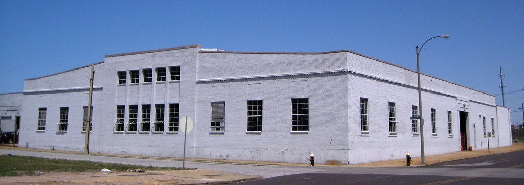
Across Chouteau Avenue from the Pevely Dairy Plant, St. Louis University has cleared several older industrial buildings. In recent days, the straw-strewn vacant lot has been awash with birds picking out the grass seeds. This prominent location, elevated above Grand Avenue to the east, now will sit idle for the time being. St. Louis University, a non-profit corporation, will not pay real estate taxes on this valuable central corridor site. Until developed, the site is producing absolutely nothing in economic good for the city.

Jeremy Claggett posted an article at nextSTL that shows how the university’s proposed ambulatory care center could occupy this newly-cleared land mass. Construction could start immediately, and the value of the Pevely Dairy Plant would increase with the investment across the street.

In the early twentieth century, urban planning became a function of city government in order to curb rampant private misuse. At its best, municipal planning ensures thoughtful lands stewardship remains an enforceable public good. This happens through a priori guidance — comprehensive planning. Commissions’ denying demolition permits serves as a negative force that can prevent careless losses of historic buildings with cultural and economic value, but such denials do not constitute effective urban planning.

St. Louis University’s land acquisitions around the medical center demonstrate that in the absence of strong municipal planning, the university has created its own comprehensive plan. That plan may lead to job creation and provision of some public goods, like ambulatory care, but it remains a plan to achieve private institutional goals. The university’s wishes for future development of the corner of Grand and Chouteau may coincide with the public good, but they are not responsive to it.

At present, the public good is manifest through citizen power brought to public meetings at the Preservation Board, Board of Aldermen and other venues. Citizens have asserted that the public good is not served by allowing demolition of the Pevely Dairy when the university has enough land to build ten ambulatory care centers and still leave the historic dairy plant standing. All people are saying is that the university’s planning should be subsumed to the interests of the entire city.

The interests of the city are not served by the university’s land-banking, nor by the university’s wanton demolition of buildings listed in the National Register of Historic Places (a not-easy-to-obtain federal designation created in 1966 that represents the public interest). The absurdity of taking down the Pevely Plant when there is a giant, fresh moonscape across the street is clear to the public, the majority of Preservation Board members and seemingly to Mayor Francis Slay. That’s a glaring point of contest, though. The larger issue remains more diffuse: St. Louis University’s planning for the medical center area is happening without the presence of assertive municipal comprehensive planning. The Pevely Dairy demolition won’t be the last battle here.

Categories
Clearance Demolition North St. Louis Old North

One Building For An Extra Lane

by Michael R. Allen

This is the former Greyhound maintenance building (built around 1950) at the northeast corner of Cass Avenue and Hadley Street, currently being demolished by the Missouri Department of Transportation (MODOT). While the building’s loss has been shown on MODOT’s plans for the new bridge landing on Cass Avenue since 2005, the actual demolition could not be more clearly pointless.

For one additional westbound lane of Cass Avenue, an entire building gets taken down — at public expense. This building and another one to its north are in great shape, with brick walls and steel roof trusses. These one-story clear-span buildings would make excellent retail stores (a supermarket in this building would be pretty cool), offices, warehouses or even just garage space. However, MODOT’s allocations are generous enough to remove considerations like wisely using existing resources, or not buying nearly entire city blocks in order to get a 20 foot easement.

Then again, with the loss of the Brecht Butcher Supply Company buildings to the west in 2007, and subsequent demolition of nearly every other building north of Cass Avenue from 14th to 10th streets, the demolition fulfills the eventual clear-cut of the south end of Old North St. Louis. Whether new buildings take the place of the old is uncertain, Crown Mart and scrap yards notwithstanding.

Categories
Clearance Infrastructure JNEM PRO Collection Riverfront South St. Louis Urban Renewal Era

Photographing the Changing Face of St. Louis

by Christina Carlson

I recently had the opportunity to digitize several photographs for the Preservation Research Office spanning from the 1930s to the 1980s. The photos consisted primarily of pictures of historic buildings and other structures in St. Louis, but also included were snapshots of parades, fairs and local people. Although many of the photos were of great interest– revealing buildings, people and spaces now forgotten — a few in particular caught my attention.

The Old Cathedral amid riverfront clearance around 1942. Photographer unknown.

At first glance this snapshot appeared to me as nothing out of the ordinary, simply another picture of the substantial efforts at demolition which took place in mid-century St. Louis. However, on a second look I recognized the iconic nature of this photo. The church in the center of frame is The Basilica of St. Louis, King of France, which sits adjacent to the Gateway Arch ground. I realized that this image captures the moment of destruction for a large swath of the riverfront area which began in 1939 and ended by 1961. Despite the conjecture of many who saw the riverfront area as a vital, ethnically and cultural diverse area, demolition of some of the oldest buildings in St. Louis was approved in 1939. In a twist of irony, much of the Eastern portion of the city was destructed to make way for a memorial to Westward expansion.[1]

Construction of the ramps connecting Interstate 44 to Interstate 55, circa 1964. The City Hospital is in the background. Photographer unknown.

Another photo I noted was one on the opposite end of the spectrum, as it portrayed the construction of the lanes of Interstate 44 where it merges into Interstate 55 south of downtown St. Louis. This image evokes a different moment in the city’s history, one in which it suddenly became much easier for those in the rapidly expanding suburbs to reach downtown, and to leave it. Although the history of suburban development in the post-war years is well known, the story in St. Louis was particularly evident. As the population shifted outward, many buildings within the city were demolished, leaving in their wake parking spaces and empty lots.

Side by side, these two images powerfully convey prominent themes in the history of St. Louis: the destruction of older, more diverse districts and the construction of vast networks of suburbs, supported by the presence of major freeways bypassing downtown. Although there are a variety of themes present in the photographs I digitized – family ties, segregation, religion, wealth, poverty – none were so prevalent as the drastic restructuring of the face of the urban landscape in St. Louis in the middle of the twentieth century.

Categories
Clearance Downtown Mill Creek Valley PRO Collection

Parade in a Lost Neighborhood

This parade shot was taken just west of Aloe Plaza near 21st and Market streets. The view is looking east toward the Civil Courts Building (at right in the background), and shows some of the Mill Creek Valley commercial district on Market Street.  The parade’s forward march follows the path of clearance that totally eradicated the African-American enclave around Union Station between 1928 and 1960.

Given the photographer’s other subjects, the date is likely after 1940.

From the Preservation Research Office Collection.

Categories
Clearance Events Historic Preservation McRee Town People South St. Louis Urbanism

Talking About McRee Town

by Michael R. Allen

Jackie Jones introduces her presentation.

Yesterday afternoon St. Louis University doctoral student Jackie Jones presented her dissertation thesis, “Picturing a Neighborhood: McRee Town in Saint Louis, Missouri,” to a crowd at the Royale, 3132 S. Kingshighway. The interesting venue for Jones’ presentation and resulting discussion offered a relaxed setting for what remains a controversial topic: the wholesale clearance of six blocks of an urban neighborhood by the Garden District Commision and resulting replacement by new housing. Jones disavowed any stance on the clearance, instead focusing on how images were used to justify the clearance in the press — and how other images contradict the story told by the Commission’s carefully-selected images.

Here’s Jones’ own description of her presentation:

In 2003, the Garden District Commission demolished more than two hundred buildings on the eastern half of the McRee Town neighborhood in Saint Louis. The Commission, a private coalition headed by officials from the nearby Missouri Botanical Garden, demolished six blocks of historic brick homes and apartment buildings that housed primarily low-income renters and homeowners, relocated hundreds of residents, erected twenty-five acres of market-rate, single-family, suburban-style housing on the cleared land, and ceremoniously renamed the area Botanical Heights. This presentation explores how visual representations of McRee Town between 1998-2003 helped legitimize this urban renewal project and the dislocations it caused in the lives of McRee Town residents. It engages viewers with the photographs of burned-out, boarded-up, weed-infested buildings that populated newspaper reports and public relations documents during these five years, and juxtaposes them with photographs taken by Genevelyn Peters, a McRee Town resident prior to the neighborhood’s destruction. These images – of family, homelife, play, and community – complicate and challenge the dominant understanding of this neighborhood and its residents as criminal and atomized by presenting images that depict a vibrant neighborhood community.

People listen to Jones’ making a point.

The people present included someone involved in the decision to clear the six blocks, residents of Botanical Heights (the new housing development), the area’s Neighborhood Stabilization Officer Luke Reven and others. While I had to leave before discussion was over, discussion touched on the damaging impact of I-44 construction in the early 1970s, the way in which similar images as those taken in McRee Town galvanized Lafayette Square and Soulard residents to pursue preservation instead of clearance, the deceptive nature of photographs and whether or not the term “suburban” applies to Botanical Heights.

Looking west down McRee Avenue from 39th Street.

On another note, if Royale proprietor Steven Fitzpatrick Smith is attempting to revive the tradition of the discussion salon, count me in!

Categories
Clearance Housing North St. Louis Northside Regeneration Pruitt Igoe

Pruitt-Igoe Demolition as Seen in "Koyaanisqatsi"

Someone has posted a long segment from Godfrey Reggio’s 1983 film Koyaanisqatsi that includes the famous aerial footage of the vacant housing project and the explosion-based demolition that took down the entire complex between 1972 and 1974.

The Pruitt-Igoe sequence begins at 2:49.

Thirty-three acres of the originally 57-acre Pruitt-Igoe site at the southeast corner of Cass and Jefferson avenues remain vacant to this day.

Categories
Clearance JeffVanderLou North St. Louis Northside Regeneration

In 1966, City Demolished 150 Buildings on Near North Side

by Michael R. Allen

According to an article that appeared in the November 26, 1966 issue of the St. Louis Globe-Democrat with the prosaic title “$151,000 Demolition Job,” the city of St. Louis was embarking upon a large-scale scattered-site clearance project on the near north side. In an area bounded by Jefferson on the east, Delmar of the south, Grand on the west and St. Louis on the north, the city was planning to demolish 150 buildings identified as substandard. This area at the time was known as Grand Prairie or Mid-City, but today is better known as the eastern half of JeffVanderLou. $101,000 of the $151,000 cost of the project came from federal funds.

This project started six years ahead of the introduction of the Team Four Plan for the wholesale deprivation of the near north side. This came ahead of widespread organized architectural surveys conducted by Landmarks Association of St. Louis and city government. This came thirty years before Paul J. McKee, Jr. set his sights on this area.

This part of the city has been long betrayed by many people. McKee’s plans are simply the endgame of decades of deprivation, demolition and neglect. However, knowing what we know now about the lack of sustainability of large-scale urban renewal projects, we should be in a better position to avoid further destroying the near north side. We don’t have the density of physical and social resources that should remain on the near north side, but we now know the value of what’s left, if only due to its scarcity.

Categories
Central West End Clearance Demolition Forest Park Southeast North St. Louis Northside Regeneration

Demolition Updates

by Michael R. Allen

MORSE SHOE FACTORY UNDER DEMOLITION

Workers have begun removing the terra cotta ornament from the O. Morse Shoe Company Building at Duncan and Boyle. Apparently, some of the ornament will be “reused” in construction of the building that will replace the venerable shoe factory building: the sleekly boring, sub-urban headquarters building for Solae. Whether or not such reuse is appropriate remains to be seen.

FOREST PARK SOUTHEAST DEMOLITION SPREE NEARLY DONE

Meanwhile, the clearance of 22 buildings in Forest Park Southeast is nearly complete. The demolitions at the north end of the neighborhood on Chouteau and Donovan avenues has created a large open space that is extremely jarring. Hopefully redevelopment will be swift. To the west, the Laclede Gas Pumping Station G will lose its landmark gasometer but retain its delightful Classical Revival pump house (built in 1910). West of there, the Freund Bread Company site has been cleared since last year, awaiting new buildings that are part of the Pumping Station project.

Overall, though, the neighborhood is looking better than ever. The transformation of Manchester Avenue within the last year has reversed the decay of many historic buildings and led to the openings of several new businesses.

BRECHT BUTCHER SUPPLY COMPANY BUILDINGS HOLDING ON

On October 10, the Building Division issued an emergency condemnation for the Brecht Butcher Supply Company Buildings. However, demolition is up to the Blairmont Associates LC of O’Fallon, Missouri, owners of the complex. So far, there is no demolition application at City Hall.

Categories
Clearance Forest Park Southeast Preservation Board South St. Louis St. Louis Board of Aldermen

Aldermen and the Preservation Board

by Michael R. Allen

Anyone who attended Monday’s Preservation Board meeting may wonder if members of the Board of Aldermen have special legal powers to defy existing laws. Actions on two items from the agenda stand out:

3524 Victor: David Guller, owner of this magnificent home in the Compton Hill local historic district, replaced windows, cornice and soffit without a permit. He was caught by a neighbor and had to apply for a permit. Unfortunately, his vinyl replacements don’t meet the local district code and when Guller made an application for a permit on the already-done remuddling the city’s Cultural Resources Office (CRO) denied his application. He appealed to the Preservation Board, which denied the appeal. Guller agreed to rework his soffit and cornice to the liking of the CRO. But he didn’t want to replace the six windows on his front elevation, and somehow appealed the denial of his appeal.

How was this even possible? Legally, it’s not. The city’s Preservation Review Ordinance holds the Preservation Board’s denial of appeal as the final deliberation, after which a matter would go to court through lawsuit. Apparently there is an unwritten exception that Alderman Stephen Conway, Guller’s representative, used to secure a second hearing at last month’s meeting. Guller did not appear, and the Board voted again to uphold the CRO denial. The item re-appeared this month, and Guller as well as Alderman Conway testified in support of his supposedly appropriate vinyl windows. The windows have embedded muntins and a terrible flat appearance; at the least, he could have sought simulated exterior muntins. best of all, Guller could re-install the wooden windows that he removed on the front elevation and keep his vinyl windows on the side and rear elevations (private elevations under city law). But he has thrown them out.

The Preservation Board smartly voted again to uphold CRO denial. If the matter comes up again, perhaps someone who supports CRO should file suit against Guller and Conway for abusing the process!

Forest Park Southeast Demolitions: The tides turned against 32 houses owned by Forest West Properties, a real estate corporation created by the Washington University Medical Center Redevelopment Corporation. Forest West sought demolition permits for all 32 and ended up receiving 22 permits, the staff recommendation of CRO. While last month’s consideration by the Board of the same matter met with widespread resentment of Forest West’s lack of a plan for and lack of communication with CRO.

This month, things had changed. Namely, Alderman Joseph Roddy’s name, absent from earlier deliberations, surfaced. CRO Director Kate Shea told the Preservation Board that Roddy had asked Forest West to buy the homes and tear them down for new construction. This fact is irrelevant to any discussion of the consequences of the demolition permit, the adequacy of their excuses for seeking one and approaches to preservation planning for these properties — but it seemed to carry weight. Never mind that only Forest West’s Brian Phillips testified in favor of demolition and that four people — Claire Nowak-Boyd, Anthony Coffin, Steve Patterson and myself — testified at length on the problems with the application.

The Preservation Board itself was diminished by the absence of members John Burse and Alderman Terry Kennedy (continuing his string of absences and becoming the third alderman in this story) and the departure of Melanie Fathman in the middle of testimony on this matter. Richard Callow recused himself after asking to split the vote on permits so that he would not vote on permits for buildings that a client was seeking to buy. For some reason, his suggestion did not go anywhere. So members Mary “One” Johnson, Luis Porello, Anthony Robinson and Chairman Tim Mulligan were left to vote. Johnson is the most uncritical cheerleader of demolition requests on the Board, with Porello often siding with her. On this matter, they were true to form with Johnson “complimenting” Phillips from the start. Robinson was oddly quiet; he would have been a voice of reason. Mulligan opposed the permits strongly last month but endorsed the staff recommendation this time.

In the end, the vote was 3-1 in favor of the staff recommendation to approve demolition of 22 buildings, with Robinson dissenting. Testimony from opponents was mostly ignored, unlike last month when it was led to enthusiastic discussion with Shea and board members.

What a difference an alderman can make!

Categories
Clearance McRee Town South St. Louis

The Destruction of McRee Town: June 2005

Looking east near the intersection of McRee and Lawrence avenues.