Categories
Brick Theft JeffVanderLou North St. Louis

Depletion, Bacon Street

by Michael R. Allen

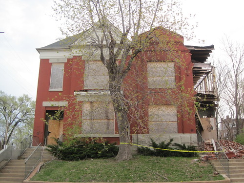
Two pairs of houses had stood on the east side of Bacon Street just south of North Market Street since before the turn of the last century. Now, three of the four are reduced to ruins by brick thieves in St. Louis’ ongoing brick theft crisis, removing more of the JeffVanderLou neighborhood’s unique architectural character and housing units that were occupied until just three years ago. Some count three buildings lost, and shrug, while others count these among over 100 lost to brick theft across north St. Louis in the last decade, and wonder when it will end.

1920 and 1924 Bacon Street

These unusual houses were both built in 1897 by the same builder.  Unusual for the surrounding area of JeffvanderLou, the houses share a party wall.  However their front elevations show differences in execution of essentially two identical (but flipped) same floorplans.  The northern house, at 1924 Bacon Street, uses flat limestone lintels and a triangular pediment that put it in the Greek Revival.  The other house employs rounded arches with ornamental label courses as well as a cornice of ornamental brick,traits that put it in the Romanesque Revival that was very popular in St. Louis during the 1890s.
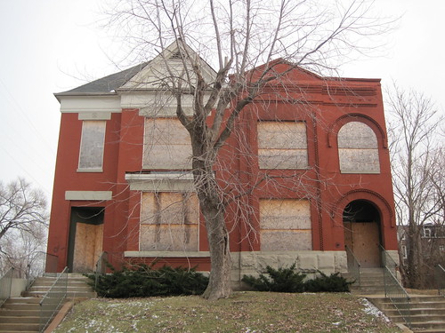
The houses at 1920 and 1924 Bacon Street in December 2009.
There is significant damage to 1920 Bacon Street in April 2011.
Categories
Abandonment North St. Louis Pruitt Igoe

Pruitt Igoe Today

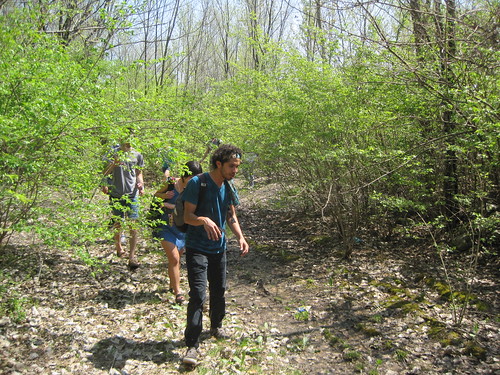
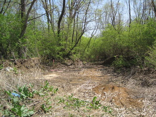
This afternoon I gave a tour of the Pruitt-Igoe site to a group of bicyclists en route to see The Pruitt-Igoe Myth. Myth meets reality, big time, on the 33 wooded vacant acres of the site. Here are few scenes. – M.R.A.

Walking the former Dickson Street.
Many participants likened the site to familiar state parks around the area.
Categories
Abandonment Industrial Buildings JeffVanderLou North St. Louis

Public Meeting on Carter Carburetor

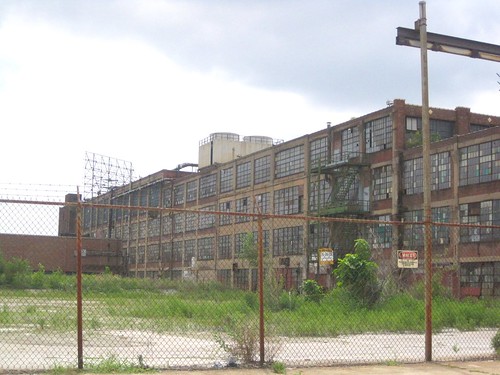
Looking southwest at the Carter Carburetor plant from Dodier Street.

WHAT: Presentation on Thermal Desorption Process for Carter Carburetor Site
WHEN: Tuesday, March 29, 2011
TIME: 7:00 p.m.
LOCATION: Urban League, 3701 Grandel Square, St. Louis, Missouri 63108

EPA is following up with leaders from the St. Louis north side community on questions received about the in-situ thermal desorption process, an alternative method for addressing contamination at the Carter Carburetor Site. An expert on the thermal desorption process will be available to meet with community leaders and other interested residents.

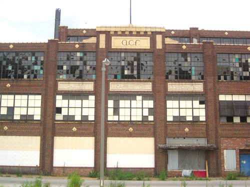
West elevation of the Carter Carburetor plant, facing Spring Avenue.
Categories
North St. Louis O'Fallon

Around Green Lea Place

Late last week our team photographed in the eastern end of O’Fallon on Green Lea Place, Harris Avenue and Clay Avenue. This pocket of the neighborhood is in the Third Ward of the city,while the rest lies in the Twenty-First. As with much of the rest of the center of O’Fallon, the development here is marked by a diversity of forms, periods and materials. There is a notable concentration of frame buildings here. Harrison School at Fair and Green Lea Place, vacant and for sale after an aborted rehab effort, is an anchor.

The influence of Romanesque Revival style is seen in the round arches, corbelling and shaped parapets of this group in the 4100 block of West Green Lea Place.
We find use of bakery and glazed brick patternwork throughout the neighborhood.
On the west face of the 4200 Harris Avenue, three-story houses with three-sided mansard roofs alternate with other brick buildings.
Categories
Benton Park Carondelet Cherokee Street Marine Villa North St. Louis Pruitt Igoe South St. Louis

St. Louis Mythory Tour

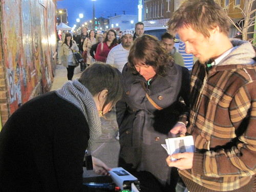
Emily Hemeyer helps two people assemble their zines at the Mythory Tour.

On Friday, as part of the epic Southern Graphics Council (SGC) Convention night on Cherokee Street, the St. Louis Mythory Tour made its debut. An expanded version will return soon, as will a new edition of the ‘zine guidebook, printed in a limited edition of 70 for Friday.

St Louis Mythory Tour
a collaborative tour and zine making workshop
by Emily Hemeyer & Michael R. Allen
May 12th, 2011. 6-9pm. Cherokee ReAL Garden. Cherokee Street. St Louis, MO

“[M]yth is speech stolen and restored.”
-Roland Barthes, Mythologies

ABOUT THE PROJECT

The built environment of St. Louis reveals itself through our observations, often clouded by nostalgia, ideology and comparison. We look around us and see inscriptions of what we imagine St. Louis to be, be that a “red brick mama”, an emergent Rust Belt powerhouse, a faded imperial capital or simply our home. St. Louis offers back its own narrative mythologies, presented through chains of linked sites with collective meanings. We quickly find that the city’s own presentation of itself is as veiled as our own observation. There is no one St. Louis, but there is no one archetypal St. Louisan.

The Mythtory Tour imagines a landscape of accrued building that has been neglected, in physical form and human consciousness. This tour presents one possible mythology of place centered on traditions of construction converging across disparate neighborhoods and many generations in order to show us St. Louis. Whether you can find this city out there is irrelevant, because using this map you will find some city worth your love and respect.


View St. Louis Mythory Tour in a larger map

THE TOUR

1. THEY BUILT WITH EARTH
Sugarloaf Mound, 4420 Ohio Street

2. THEY BUILT WITH STONE
Stone House, 124 E. Steins Street

3. THEY BUILT TO PRODUCE
Lemp Brewery, southeast corner of Cherokee & Lemp streets

4. THEY BUILT IN THE AIR
Pruitt-Igoe Site, Southeast Corner of Cass and Jefferson Avenues

5. THEY BUILT FOR THE FUTURE
Kingshighway Viaduct, Kingshighway Boulevard Between Vandeventer and Shaw
Avenues

6. THEY BUILT UNDERGROUND
Cherokee Cave, Under Cherokee Street at DeMenil Place

7. THEY BUILT ON THE WATER
U.S.S. Inaugural, Foot of Rutger Street

(Full descriptions and photographs of each location are available in the guidebook. Those interested in ordering a copy can contact Michael Allen at michael@preservationresearch.com.)

Categories
North St. Louis O'Fallon

O’Fallon Neighborhood Survey Continues

Yesterday the Preservation Research Office staff spent the morning undertaking our second session of intensive photography for the neighborhood-wide architectural survey funded by Alderman Antonio French through The Acts Partnership. We are photographing each and every one of the neighborhood’s lovely buildings in order to prepare descriptions of each one needed for the National register of Historic Places historic district nomination we will submit this year.

Here are some of yesterday’s scenes.

These two connected buildings are at the southwest corner of Lee and Warne avenues.
This Tudor Revival apartment building is at the southwest corner of Clay and Lee avenues.
Categories
Infrastructure North St. Louis O'Fallon Streets

Brick Alleys in the O’Fallon Neighborhood

As the Preservation Research Office team conducts its architectural survey of the O’Fallon neighborhood of north St. Louis, it has noted the presence of several intact historic brick alleys. Paved with “paver” bricks made by local manufacturers in the last 19th and early 20th centuries before the rise of concrete street paving, brick alleys are part of the built landscape of the neighborhood — and the city. Unfortunately brick alleys have disappeared along with brick streets. O’Fallon is fortunate to have some remaining in good repair. Those shown here can be found in the H-shaped alley network between Fair, Green Lea, Clay and Penrose streets.

Brick alley running north between Penrose Street and Green Lea Place just west of Clay Avenue.
Brick alley running north from Penrose Street to Green Lea Place just east of Fair Avenue.
Categories
Churches North St. Louis O'Fallon

Help Turn a Vacant Church Into a Community Center

From the Acts Partnership

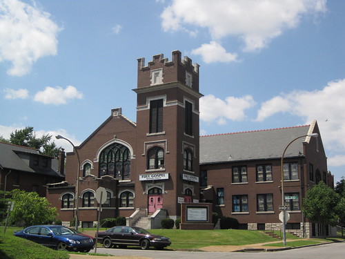
The former Full Gospel Apostolic Church, built in 1913 as the Bethany Evangelical Church.

The Acts Partnership is partnering with Alderman Antonio French to purchase a beautiful, vacant, historic church building to house services for youth and seniors. The response has been great since we first put out the call for help last week. We’re almost there! But time is running out. THE SALE CLOSES ON MONDAY! So if you haven’t yet, please make a donation today to help a great 21st Ward non-profit purchase this historic vacant church building to make it a home for services for youth and seniors.

Channel 2 covered the effort this week:


The building, located in the O’Fallon neighborhood just a block away from O’Fallon Park, stands on the corner Red Bud and Rosalie Streets. The Incarnate Word Foundation, a great partner and supporter of north St. Louis, has agreed to matching generous donation so if you can donate $50 today, The Incarnate Word Foundation will match your donation with another $50! So give today and help us stabilize the community and provide services to seniors and youth this summer.

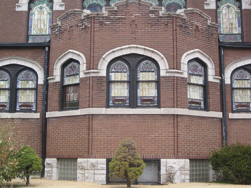
Detail of bay on the church.

Donate here.

Categories
Events North St. Louis Riverfront

Two North Riverfront Public Meetings in March

Branch Street Connector Public Meeting
Thursday, March 10

5:30pm – Branch Street Walk-Through
6:00pm – Meeting and Visioning Session

LOCATION: For both the walk-through and the meeting, meet at Old North Restoration Group Office, 2700 N. 14th Street

The Mississippi River, the Riverfront Trail, and the McKinley Bikeway are incredible resources that are just a 10-minute walk or 5-minute bike ride from our community, but most of us rarely visit them because we don’t have safe access. Branch Street is our community’s only remaining direct connection to these assets. We need your help to create a new vision for Branch Street. Please join us for a walk-through and visioning session to identify the major issues and generate ideas for improving Branch. The meeting will include an update on the Trestle project from Great Rivers Greenway staff.

Port/North Riverfront Land Use Study Public Informational Meeting
Thursday, March 24, 2011 – 4:00pm until 6:00pm

Metropolitan Sewer District (MSD) Bissell Point Waste Water Treatment
Plant
Environmental Compliance Building Auditorium
10 East Grand Avenue, St. Louis, MO 63147

The North Riverfront of the City of St. Louis (stretching from Mallinckrodt at the south end to Cementland at the north) is currently undergoing a RFP process for long-term land use planning. This area accounts for over a third of the entire Mississippi River frontage of the city of St. Louis, is home to the Riverfront Trail, proposed Iron Horse Trestle, and a good percentage of historical industrial architecture.

Directions:
1. Take I-70 to Grand Avenue
2. Go east until Grand Avenue dead-ends at the front gates of the MSD Bissell Point Wastewater Treatment Plant
3. Enter the front gates and follow the signs to the Environmental Compliance building
4. The auditorium is located inside this building, just to the left as you enter the front doors.

Categories
Historic Preservation North St. Louis O'Fallon

Scenes from the O’Fallon Neighborhood

The 4400 Block of Holly Avenue.

Yesterday, we conducted the first of several intensive photographic excursions needed for our survey of the O’Fallon neighborhood. By the time we are done with photography this month, we will have photographed an estimated 1,796 buildings in the area roughly bounded by Newstead/Pope avenue, O’Fallon Park, Warne Avenue, Fairground Park and Natural Bridge Avenue. Our work yesterday took us around the Plymouth Park subdivision just south of O’Fallon Park, where we walked Carter, Clarence, Holly, Red Bud, Harris, Fair and Rosalie avenues.

Next we will write a narrative description of each building. Simultaneous to all of this work, we are examining the city’s building permit records on microfilm to learn the date of construction, cost, designer, builder and original owner of each building. This is a tall order, but needed to create a National Register of Historic Places historic district for the entire O’Fallon neighborhood.

As we work, enjoy some of yesterday’s photographs.

Corner two-part commercial building at Rosalie and Clarence avenues.
The 4400 block of Harris Avenue.