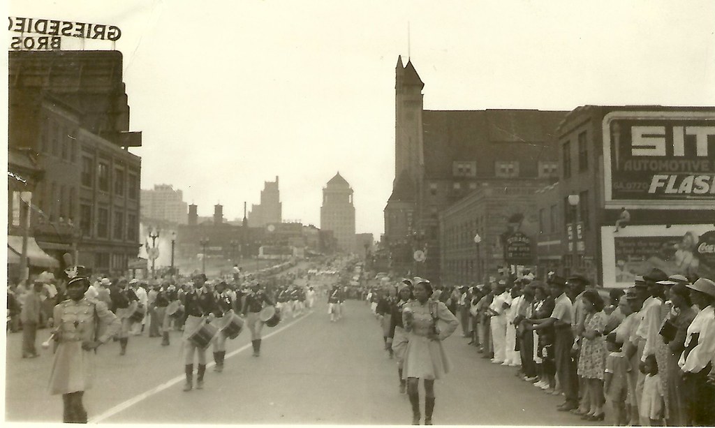
Another photograph from our collection of amateur images of the St. Louis built environment captures a parade moving westward down Market Street into Mill Creek Valley. The view was taken west of 21st street, and shows a panorama of the mid-century downtown skyline. Lacking a date, the image nonetheless offers a major clue: the surging waters of fountains around Carl Milles’ The Marriage of the Waters in Aloe Plaza can be seen at left. That installation was completed in 1940.
The image was taken before 1954, because the photograph shows blocks of vernacular, small-scale buildings between 18th and 15th streets that would be leveled for park space. Eventually this landscape would become the Gateway Mall. The buildings in the foreground would be leveled after 1959 as part of Mill Creek Valley clearance. Later, this area would be rebuilt with depressed on-ramps as part of the stalled North-South Distributor project.
Somewhere between the triumph of early intervention and later, more troubling urban renewal, a parade passed through this scene. The moment captured shows the African-American community of Mill Creek Valley in celebration, right in the heart of the city. By 1965, this community would be forever removed, and its built environment replaced by an uninspired landscape. Today city leaders have embraced the Northside Regeneration project, which calls for reconstructing the urban street grid west of Union Station and building dense infill there. Yet this photograph reminds us that architectural character is only the backdrop for urban cultural experience. Mill Creek Valley’s lively culture will never return to Market Street, and for that this city is worse.
This is the ninth and final part of a series on the evolution of the Gateway Mall, that ribbon of park space that runs between Market and Chestnut streets and from the Jefferson National Expansion memorial westward to Twenty-Second Street downtown. This article began its life as a lecture that I delivered to the Friends of Tower Grove Park on February 3, 2008, and was published in its entirety in the NewsLetter of the Society of Architectural Historians, Missouri Valley chapter in Spring 2011.
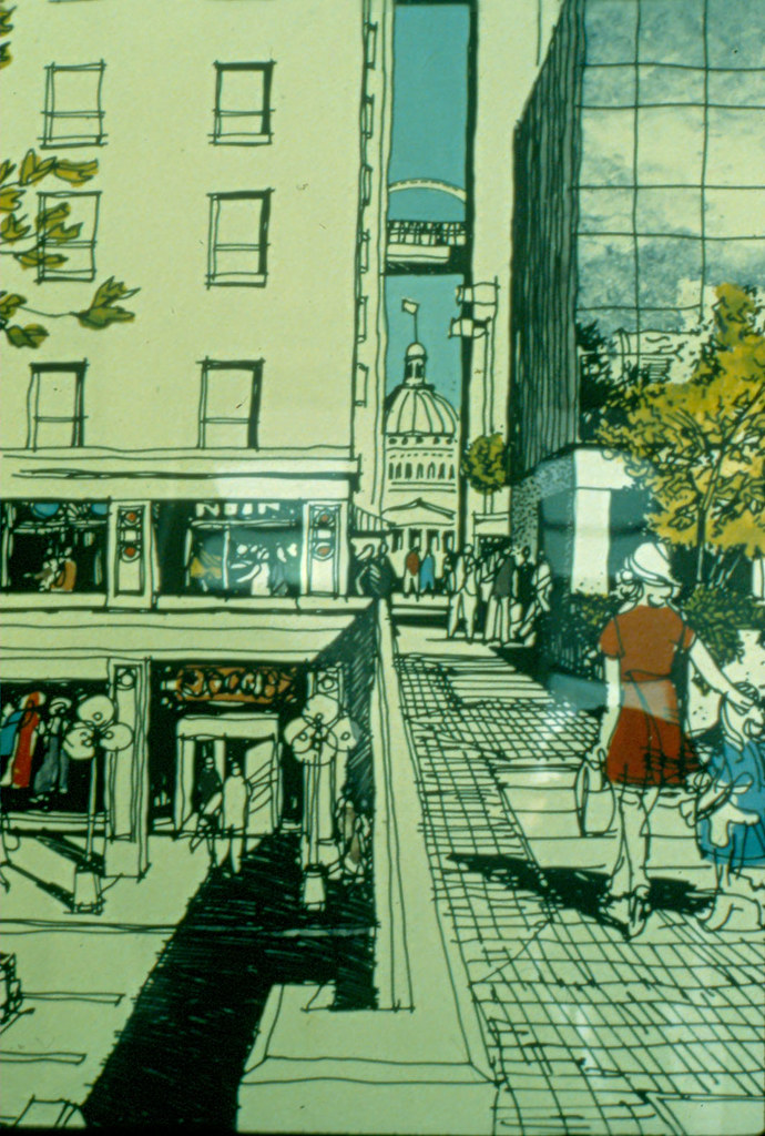
The concept rendering for Citygarden.
The 2007 Gateway Mall master plan provided impetus to the development of the two blocks of the mall between Eighth and Tenth streets as the successful Citygarden. Designed by Nelson Byrd Woltz architects and completed in 2009, Citygarden is an interactive sculpture garden that has garnered favorable criticism from the New York Times. Citygarden’s two blocks share the “hallway,†a wide formal tree-lined sidewalk along Market Street recommended by the new Gateway Mall Master Plan. However, the blocks eschew further strict formalism. Linear paths follow the somewhat irregular lines of long-abandoned alleys, while a gentle arc runs through both blocks. The north sides are raised up, with the eastern block containing a waterfall and minimalist cafe building on its high side and the western block rising up to a whimsical forested hill atop which is placed a sculpture. There is a plaza on the western block alive with fountain jets adjacent to a grid of large metal pedals upon one which one can jump to trigger bells at different tones. All of the sculptures can be touched. Citygarden has been so successful that the section of 10th Street between the two blocks remains closed to shield the heavy pedestrian traffic.
The pre-construction plan for Citygarden.
Citygarden’s design discarded rationalist notions of open space and view in favor of a contemporary landscape design theories of the need for activation, asymmetry, whimsy and native plantings. The small size of the intervention — two blocks — creates clear boundaries and edges of Citygarden that drive pedestrians into its space. The success of Citygarden in part comes from employing long-standing observations about the utility of basic urban design features that encourage circulation and building density.
This is the eighth part of a nine-part series on the evolution of the Gateway Mall, that ribbon of park space that runs between Market and Chestnut streets and from the Jefferson National Expansion memorial westward to Twenty-Second Street downtown. This article began its life as a lecture that I delivered to the Friends of Tower Grove Park on February 3, 2008, and was published in its entirety in the NewsLetter of the Society of Architectural Historians, Missouri Valley chapter in Spring 2011.
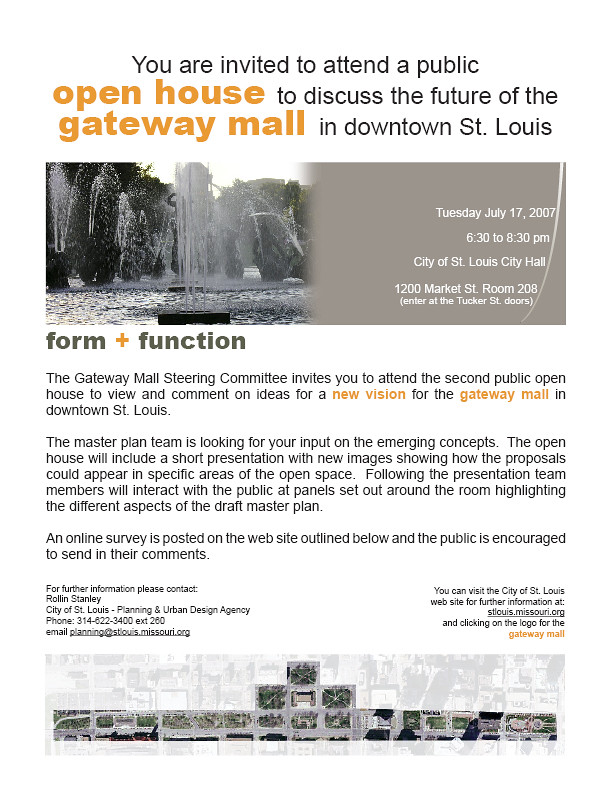
A flier announcing a 2007 event for the master plan process.
St. Louis Mayor Francis Slay and Planning and Urban Design Director Rollin Stanley announced in 2007 their intention to create a Gateway Mall Master Plan in association with landscape architect Thomas Balsley. Their plan would be the first comprehensive plan for every block that had become part of the mall, as well as the rest of Memorial Plaza. Recognizing the design failure of the Gateway Mall, Stanley envisioned a break from the past — a mall friendly to pedestrians and built around uses that attract people. Stanley and Slay went farther than most actors in this drama and admitted that the Mall needed real planning. They didn’t want to extend it or glorify it but improve it.
The eastern mall blocks in 2007. (Source: nextSTL, nextstl.com)
Unfortunately, their plan was too constrained by the old rationalist vision to be a blueprint for major improvement. For one thing, they were committed to preserving every block of the Mall as green space — a questionable proposition in a downtown with as much open space as ours. For another, their plan avoided recommendations for improving the mall’s context. The large-scaled environment around the Mall is as resistant to human action as the park itself; it’s a chicken and egg relationship and the new Master Plan acted like an ostrich.
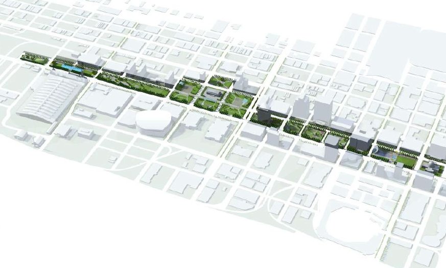
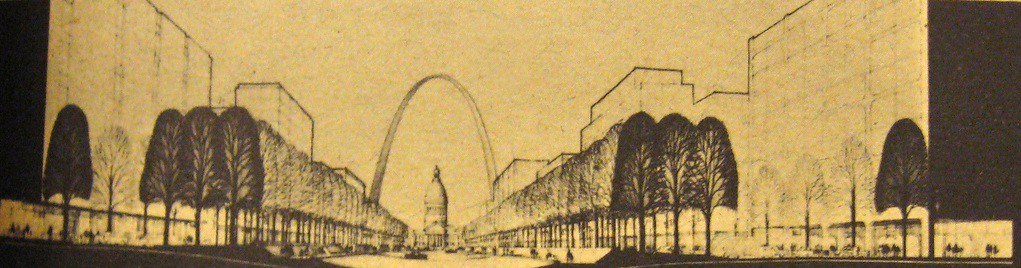
The master plan's envisioned terminus on the western block.
Still, there were good ideas in it. The plan avoided trying to visually unify the mall, except for a southern bike lane and promenade. The plan acknowledged the variation in block width and the curving streets that make symmetry impossible. Instead, the mall plan recommends creating different zones on the mall — a sculpture garden between Eighth and Tenth; recreation areas and a dog park west of Fifteenth street; an amphitheater-style space on Memorial Plaza; a gathering space in Kiener Plaza.
The master plan's imagined aerial view of the revised Gateway Mall landscape.
The plan tried to match these zones to adjacent uses without looking at the physical connections between. For instance, the sculpture garden introduced a rather romantic vision of human-scaled green space near downtown residences and offices. But it’s flanked to the north and south by large, monolithic office buildings set back from the sidewalk and possessing reflective windows and intrusive driveways. A walk from the north side of downtown to the sculpture garden won’t provide much delight or instruction if it passes by the bizarre sidewalk configuration on the west or east sides of the AT&T tower, for instance.
The master plan recommended more seating, a walking and running path, kinetic art on adjacent buildings, and lighting on the blocks that would make them attractive night time spaces. There was some break-down of barriers with a small restaurant building in the sculpture garden. But in some ways the restaurant and the dazzling contemporary art are low-key, updated versions of the monuments and buildings of the 1919 Public Building Group Plan.
Memorial Plaza as "The Civic Room" in the master plan. View is toward the northwest.
At the Gateway Mall press conference in 2008, Mayor Slay declared a “new era” for the Gateway Mall. This era was new inasmuch as it is based on planners’ admission of the mall’s failure. However, the failure has always been systematic and structural, while the solutions outlined in the new Master Plan were topical and aesthetic. Rather than address crucial problems of identity, circulation and boundaries, the new Master Plan treated those as secondary causes by offering a remedy not to the idea of a Gateway Mall but to its execution.
This is the seventh part of a nine-part series on the evolution of the Gateway Mall, that ribbon of park space that runs between Market and Chestnut streets and from the Jefferson National Expansion memorial westward to Twenty-Second Street downtown. This article began its life as a lecture that I delivered to the Friends of Tower Grove Park on February 3, 2008, and was published in its entirety in the NewsLetter of the Society of Architectural Historians, Missouri Valley chapter in Spring 2011.
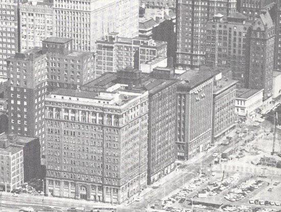
Real Estate Row. The view northward from Market Street along Seventh Street from bottom to top includes the Buder, Title Guaranty, Wainright, DeMenil and Holland buildings. Only the Wainwright remaims. (Source: Scan from Rob Powers, builtstlouis.net.)
At the end of the 1970s, after failing to build the winning design from the 1967 design competition, city leaders did not let the dream of a “completed” Gateway Mall die. There still were blocks of old buildings to clear and new corporate high-rises to attract. However, developer Donn Lipton seized the opportunity of city inaction and in February 1977 submitted a redevelopment plan for the blocks between Seventh and Tenth streets radically different than the Sasaki plan.
Rendering of the Lipton plan looking east from just past Eighth Street. (Source: Landmraks Association of St. Louis.)
This is the sixth part of a nine-part series on the evolution of the Gateway Mall, that ribbon of park space that runs between Market and Chestnut streets and from the Jefferson National Expansion memorial westward to Twenty-Second Street downtown. This article began its life as a lecture that I delivered to the Friends of Tower Grove Park on February 3, 2008, and was published in its entirety in the NewsLetter of the Society of Architectural Historians, Missouri Valley chapter in Spring 2011.
In March 1966, an undeterred Mayor Alphonso Cervantes traveled to New York City for the public announcement of a national design competition with a $15,000 prize for a master design for the entire Gateway Mall. The city and Downtown St. Louis, Inc. sponsored the design competition. Fifty-seven firms or individuals submitted designs before the winner was announced in June 1967.
View toward the Old Courthouse from Seventh and Chestnut, in 1968, showing the future site of the Morton D. May Ampitheater. (Preservation Research Office Collection.)
The boundary of the competition was set with the Old Courthouse at the east and the proposed North-South Distributor (roughly Twenty-Second Street) at the west. the competition was the first attempt at a master plan for a landscape that was merely six years old in the minds of planners. By this time, downtown had lost so much building stock and street life that the old rationalist rhetoric about alleviating the ills of the central city would have been ludicrous. Instead, Cervantes and civic leaders began to talk up the effect of the Gateway Mall as an instrument that might lead to building up the core. With the Mall extended, they argued, Chestnut and Market streets would become desirable sites for the sorts of large corporate headquarters St. Louis desperately wanted to attract. The rhetorical emphasis shifted from social to economic benefits, but the rationalist framework remained latent.
One of Sasaki, Dawson & DeMay's dramatic renderings of the Gateway Mall concept published in Architectural Forum.
This is the fifth part of a nine-part series on the evolution of the Gateway Mall, that ribbon of park space that runs between Market and Chestnut streets and from the Jefferson National Expansion memorial westward to Twenty-Second Street downtown. This article began its life as a lecture that I delivered to the Friends of Tower Grove Park on February 3, 2008, and was published in its entirety in the NewsLetter of the Society of Architectural Historians, Missouri Valley chapter in Spring 2011.
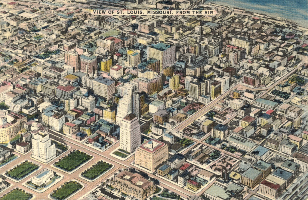
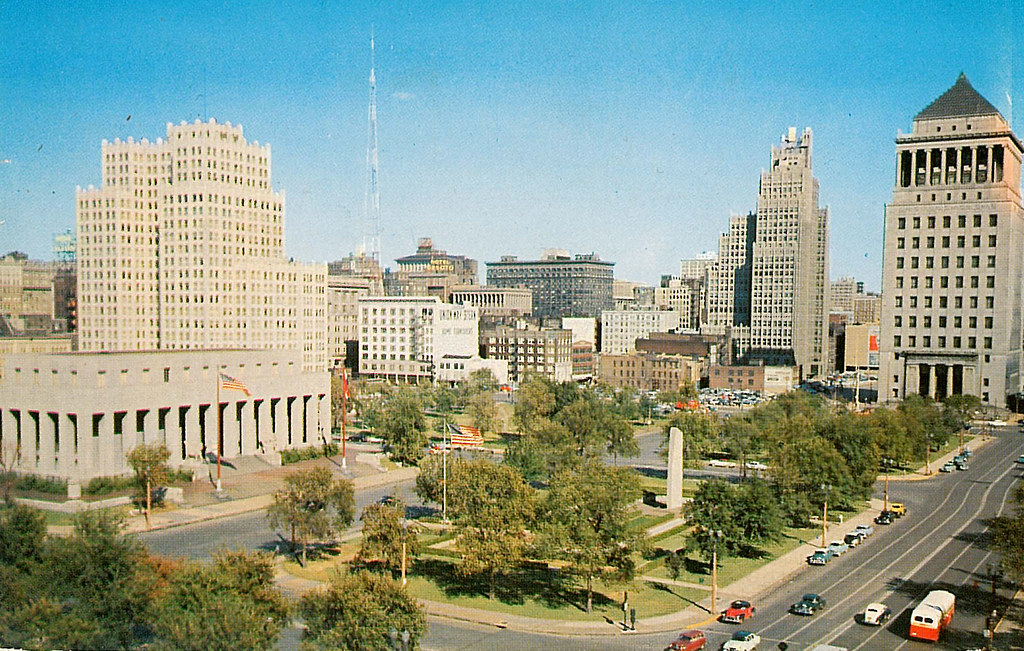
This aerial rendering of downtown St. Louis shows the relationship between Memorial Plaza (left) and the downtown core in which the Gateway Mall would be built. (Postcard, c. 1940.)
Selection of Eero Saarinen and Dan Kiley’s plan for the Jefferson National Expansion Memorial design in the 1948 design competition drew planners’ attention to eastern downtown. In 1954, the architectural firm Russell, Mullgardt, Schwarz & Van Hoefen published a rendering of an eastern park mall running from the Civil Courts and terminating at the new Memorial. The block between Third (now Memorial Drive) and Fourth Streets would be landscaped by the National Park Service as part of the Memorial and named Luther Ely Smith Square. The firm’s rendering was the first time that the idea of extending the downtown park system to the east had been considered.
The rendering by Russell, Mullgardt, Schwarz & Van Hoefen coincided with creation of the western blocks between Fifteenth and Eighteenth streets between 1954 and 1960. Those blocks joined existing Memorial and Aloe plaza blocks to form a mall-like line of parks from Twelfth Street (later Tucker Boulevard) west to Twentieth streets. The new Jefferson National Expansion Memorial and Luther Ely Smith Square shaped an eastern terminus for the larger park project that would soon be named the Gateway Mall.
The eastern part of the park mall is clearly visible in this 1960 rendering for the downtown plan by Erwin Carl Schmidt.
Yet the Civil Courts Building and the Old Courthouse were obstacles to a continuous park mall. Still, the rendering of formally symmetrical park space joining the existing Memorial Plaza and park mall at the west to the Memorial at the east was immediately popular. Anticipating timely completion of the Jefferson National Expansion Memorial, downtown business leaders wanted to reconstruct eastern downtown with a modern built environment worthy of a major international landscape.
This is the fourth part of a nine-part series on the evolution of the Gateway Mall, that ribbon of park space that runs between Market and Chestnut streets and from the Jefferson National Expansion memorial westward to Twenty-Second Street downtown. This article began its life as a lecture that I delivered to the Friends of Tower Grove Park on February 3, 2008, and was published in its entirety in the NewsLetter of the Society of Architectural Historians, Missouri Valley chapter in Spring 2011.
1950s view of the realized civic center, Memorial Plaza, looking northeast with the Soldiers' Memorial at left and the Civil Courts at right. (Preservation Research Office Collection.)
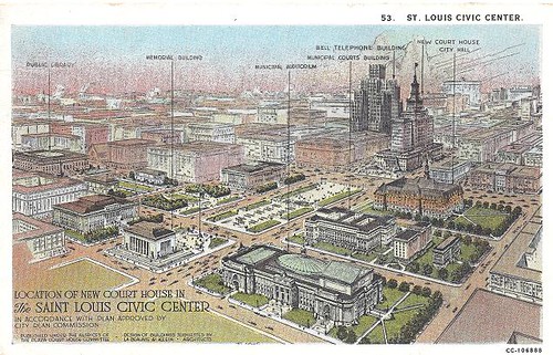
In 1919 the City Plan Commission published A Public Building Group Plan. The plan called for creation of green space on blocks between 12th, Market, 14th and Chestnut streets, with two blocks extending north to the Central Library on Olive between 13th and 14th Streets. The plan called the center spine between the library and the Municipal Courts building “the mall.” All around this park space would be new civic buildings, including a massive auditorium, a court house and others. To the west, a new plaza would be built across from Union Station. The plazas would be further adorned with fountains, an obelisk, and statues for a park environment devoid of nature fully designed as monumental space.
Postcard rendering of the 1919 Public Buildings Group Plan. (Preservation Research Office Collection.)
The title page of A Public Building Group Plan bore the name of the new City Engineer, Harland Bartholomew, whose persistence and commitment to City Beautiful principles breathed new life into St. Louis’ 15-year-old plan for a civic center. Bartholomew may not have authored every word, but his philosophy is evident throughout. In the introduction, the author states that “it behooves the city to so design its public buildings that these may faithfully and fittingly depict the civic spirit.” To Bartholomew, new public buildings were more than beautiful buildings in which government conducted affairs. These buildings were, at their best, symbols of civic commitment to imposing order and beauty on the urban condition. Bad public buildings were signs of urban chaos represented in St. Louis’ hodgepodge downtown fabric.
The report states that a public building group would be a monumental visual statement about St. Louis’ posture toward its physical fabric. In the report, a public buildings group is lauded as a “medium of good civic advertising†that would promote real estate development through property value increases on adjacent property. The civic center formed by a public buildings group would also become the “veritable heart of the city,” a place at which major traffic lines intersected and through which few human and vehicular traffic would not pass. This bustling depiction is not exactly what St. Louis would build.
This is the third part of a nine-part series on the evolution of the Gateway Mall, that ribbon of park space that runs between Market and Chestnut streets and from the Jefferson National Expansion memorial westward to Twenty-Second Street downtown. This article began its life as a lecture that I delivered to the Friends of Tower Grove Park on February 3, 2008, and was published in its entirety in the NewsLetter of the Society of Architectural Historians, Missouri Valley chapter in Spring 2011.
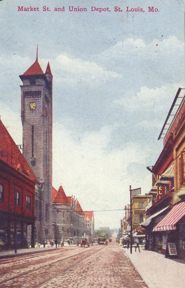
Postcard view (c. 1900) showing Market Street looking west toward Union Station from about 17th Street. (Collection of the St. Louis Building Arts Foundation.)
The 1907 Comprehensive Plan’s call for a civic plaza blossomed after the establishment in 1909 of a permanent City Plan Commission. In July 1912, the City Plan Commission recommended to the Board of Alderman a plan called the “Central Traffic-Parkway.” The published report was illustrated with many photographs of “the blighted district” located on Market and Chestnut streets downtown. Described as the initial step in building a greater city, the plan called for the clearance of every block between Market and Chestnut streets from 12th Street west to Jefferson, which would be 26th by number. On these blocks would be built a modern parkway, with divided lanes in each direction and ribbons of green space planted with uniform rows of trees and lawns. The parkway plan called for eventual extension to Grand Avenue. No mention was made of eastward extension.
Although more of a traffic way for automobiles than a true park system, the 1912 design and description were fully rooted in the City Beautiful notion of park function. The theory behind the plan was that the blight of the central city — blight of overcrowded buildings and congested small streets — needed to be supplanted by an orderly place of defined purpose. Here would be a modern space for both vehicular traffic and human recreation. In turn, the parkway would foster stronger property values in adjacent sections and lead to the construction of new tall buildings. This would be the spine of the renewed city, and it would transmit improvement in economy and morality.
This is the second part of a nine-part series on the evolution of the Gateway Mall, that ribbon of park space that runs between Market and Chestnut streets and from the Jefferson National Expansion memorial westward to Twenty-Second Street downtown. This article began its life as a lecture that I delivered to the Friends of Tower Grove Park on February 3, 2008, and was published in its entirety in the NewsLetter of the Society of Architectural Historians, Missouri Valley chapter in Spring 2011.
Landscape architect George Kessler was one of the chief theorists of rationalist urban planning. Kessler designed the 1904 World’s Fair landscape, which was a masterpiece of orderly expansive views. Kessler had little use for formal gardens or wildness; he favored large neat orderly lawns defined by imposing trees or dramatized by the placement of ornate buildings. Rather than emphasize the delights of natural flora, Kessler underscored the beauty of a total landscape. At the Louisiana Purchase Exposition of 1904, this landscape included ornate Beaux Arts buildings. Here was a mirror of the early ideal of the Gateway Mall — orderly formal landscape contained by monumental public buildings. Mayor Rolla Wells was a supporter of Kessler and put him to work on several urban planning projects, including a plan for Kingshighway that envisioned the road as a true parkway.
The site of the future Gateway Mall circa 1928, looking east from about 21st Street, with Union Station and Market Street on the right. (City Plan Commission photograph.)
In the absence of an official city government planning apparatus, the reform-minded Civic League created a City Plan Committees to undertake the first comprehensive city plan in 1905. The Plan Committees included numerous prominent businessmen, political leaders, architects and engineers. The Committee published the city’s first Comprehensive Plan in 1907. The Committee reported that there was one acre of park for every 96 people living west of Grand and one acre for every 1,871 between Grand and the river. The Committee found this density undesirable and recommended creating additional park space through clearance. One-hundred years later, after decades of demolition in the central core of our city has destroyed entire neighborhoods and rendered others dysfunctional, the Committee’s plan seems short-sighted. The difference recorded in the number of park acres east and west of Grand did not necessarily indicate any real difference in quality of life. It simply recorded a greater building density east of Grand in the oldest walking neighborhoods of the city. Later city planners would to appreciate the boost high building density gives to fostering strong community ties, creating safe streets, creating vital commercial districts, and raising property values.
This building at 1403 Pine Street, photographed in the 1930s, is typical of the housing stock planners wanted to remove from western downtown.(Preservation Research Office Collection.)
Today we publish the first part of a nine-part series on the evolution of the Gateway Mall, that ribbon of park space that runs between Market and Chestnut streets and from the Jefferson National Expansion memorial westward to Twenty-Second Street downtown. This article began its life as a lecture that I delivered to the Friends of Tower Grove Park on February 3, 2008, and was published in its entirety in the NewsLetter of the Society of Architectural Historians, Missouri Valley chapter in Spring 2011.
Looking east down the Gateway Mall in 1970. (Collection of Landmarks Association of St. Louis.)
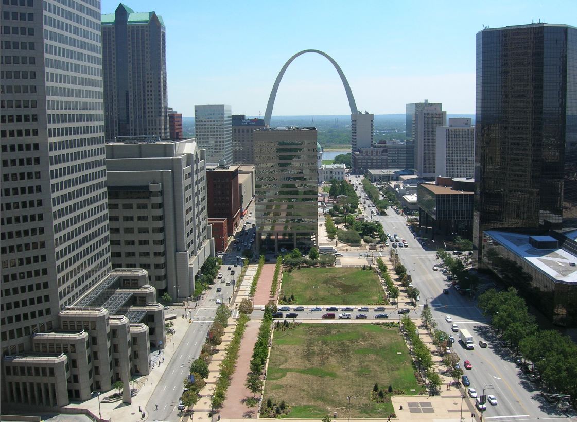
Let’s review: The Gateway Mall is a line of parks that runs between Chestnut and Market Streets from Memorial Drive west to 22nd Street. Right?
Other than the handful of destination blocks, few St. Louisans could readily identify the visual characteristics that define the Gateway Mall. Descriptions of the mall, like the one that I just offered, typically revert to geography. The mall’s boundaries are street names. The mall’s identity lies in what surrounds it, and not in inherent qualities that the user of Forest or Tower Grove parks offers to someone unfamiliar with those spaces. Reliance on a geographic description of the Gateway Mall is quite gentle, because to enumerate what the mall contains hardly portrays an attractive green space.
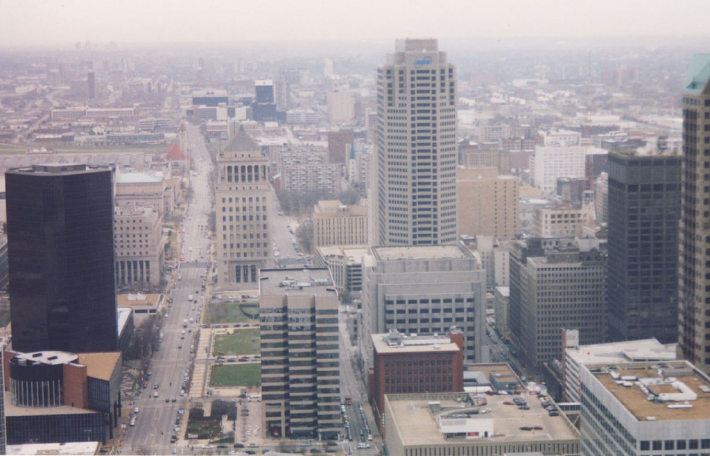
Can you spot the park mall in this aerial phtograph of downtown? (Photograph by Rob Powers, builtstlouis.net, circa 2004.)
We have a jumble of mismatched blocks, from the passive formal parks across the street from City Hall to the postmodern ruins of Kiener Plaza to the sunken garden between the Old Courthouse and the Arch. We have monumental blocks like Aloe Plaza and the Richard Serra sculpture block that lose all of the drama of monumentality by being placed alongside interceding dull blocks of dead park space. We have interruptions like the Civil Courts and the Old Courthouse, a fairly pleasant juxtaposition if only there were not a poorly-wrought 1980s standing between the two. Some blocks are wide, some are narrow. Some are standard length and others form smaller super-blocks. The whole mall is almost hinged around the Civil Courts building, where Market Street bends slightly southwest. That bend precludes true symmetry.
The view east from 20th Street. Here the view is pretty much coherent.
So what do we have? Currently, we have a green space running through downtown named the Gateway Mall. Is it a park? Landscape historian Tom Turner writes in his book City as Landscape: “If the space has no boundary, it should not be called a park. And if it has a boundary, the boundary should have a defined purpose.”
The Gateway Mall has no historic boundary. That is, its boundaries have shifted under various plans. Originally, it would have extended between Grand and 12th (now Tucker). Later plans had it extending east to meet the Arch. Nowadays, it does start at the western edge of the Arch grounds but ends rather haphazardly past 21st street. The terminus is a chain link fence separating and irregularly shaped block from a highway ramp.