Categories
Cherokee Street Gravois Park South St. Louis

Foreclosures and Demolition in Gravois Park

by Michael R. Allen

Vacant lots silently are starting to multiply on the city’s “state streets,” especially in parts of Gravois Park and Dutchtown between promising business districts on Cherokee Street and Meramec Avenue. Even worse are the innumerable signs of future trauma: bleached-red plywood, windows gasping through shards of broken glass, front doors hung ajar, downspouts and gutter pans already smelted in blast furnaces outside Beijing and weeds that cannot be cut enough to stay low. While much attention has been shed on vacancy’s impact on the north side, the south side is showing the signs of a future crisis.

Foreclosure has been a huge factor making neglect more difficult to sustain. As waves of investors abandoned underwater multi-family buildings, the vacancy rates soared in Benton Park West, Gravois Park, Dutchtown and other neighborhoods. In 2008, the federal Department of Housing and Urban Development awarded the city a $5.6 million grant to purchase and rehabilitate foreclosed homes. Under the direction of then-Deputy Mayor for Development Barbara Geisman, the city’s Community Development Administration targeted those funds in Gravois Park, Benton Park West and Dutchtown. At the time, the city projected the purchase of 87 homes and an application to receive $10 million toward purchasing 231 more.

3006-8 Cherokee Street in 2003. Image from Geo St. Louis.
Categories
Benton Park West Cherokee Street Gravois Park PRO Collection South St. Louis

Cherokee Street Decorated for the Holidays, 1940s

by Michael R. Allen

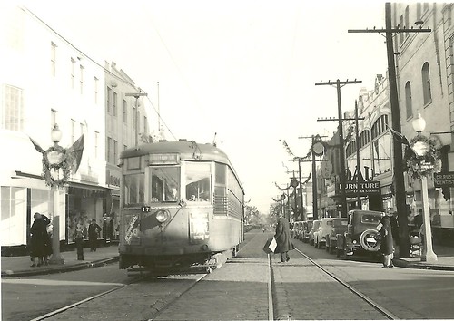
Undated photograph showing the view down Cherokee Street east from Iowa Avenue. Preservation Research Office Collection.

These two photographs from our collection show two eastward views from the late 1940s down Cherokee Street around Christmas time. Amid the wreaths decorating street lights are an array of shoppers and so many projecting store signs that a count seems impossible. These photographs really make clear how much signs and marquees are visually interesting and worthy parts of the historic built environment, unfortunately now discouraged or effectively outlawed in commercial districts by zoning and local historic district ordinances. (Apparently turning on a stopped historic clock on Cherokee Street is even controversial to the city government, despite the clock’s clear role in the physical fabric.) An exact date for these two photographs, taken on the same roll of film, has not been determined but visual information likely set the year between 1945 and 1950.

Also present is the tension between modes of transportation. The streetcar, whose sign reads “Jefferson Line” in the photograph above, is dominant in the center of the street, but parked automobiles outnumber the streetcars and their rider capacity. Soon they would be the only motor vehicles on Cherokee Street.

Above, we see the Casa Loma Ballroom at left in its present appearance, which dates to reconstruction following a fire in 1940. The Dau Furniture Company marquee at left projects from a lavishly-detailed terra cotta front on the building at 2720 Cherokee (1926, Wedemeyer & Nelson). To its right is part of the former Cherokee Brewery. Almost every building in this scene still remains.

Undated photograph showing the view down Cherokee Street east from Ohio Avenue. Preservation Research Office Collection.

To the east at Ohio Avenue, the view is even more abundant with blade signs touting various stores and companies on Cherokee Street. The northeast corner building, now home to Los Caminos gallery, was the the home of the South Side Journal. Frank X. Bick founded the newspaper in 1932, and it is now part of the Suburban Journals with an office in West County. Other signs include those for Fairchild’s and Stone Bros. attached the a now-vacant building once operated by Anheuser-Busch as the Kaiserhoff, and one in the far background for Ziegenhein Bros. Livery & Undertaking Company. Visible diagonally across the street from Ziegehein Bros.’ building is the sign of 905 Liquors, housed at Cherokee and Texas in what became the home of Globe Drugs. At the time this photograph was taken, murals by artist J.B. Turnbull adorned the walls of that particular location of 905.

Categories
Gravois Park Infrastructure South St. Louis

Brick Alley Restoration Underway in Gravois Park

by Michael R. Allen

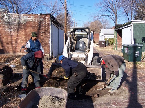
Recently I wrote about two lovely intact brick alleys in the St. Louis Place neighborhood on the north side (see “St. Louis Place: Sidewalk Plaques and Brick Alleys”, February 11). After publishing that post, I learned that there is a pilot program underway to restore 17 brick alleys in two of the city’s south side historic districts, the Gravois-Jefferson Historic Streetcar Suburb District and the Benton Park Historic District. Some work began in December in Gravois Park, and more will start when weather is consistently dry. Work will be completed by August 10, 2011.

A crew working in December 2010 on brick removal in the alley between the 3500 blocks of Louisana and Tennessee Avenues. Photograph by Eric Bothe.

When alderpeople put in requests for allocation of the city’s American Recovery and Reinvestment Act funds, Alderman Craig Schmid (D-20th) successfully applied for $975,000 to restore and retain historic brick alleys in the historic districts of his ward. The city’s Department of Streets stopped repairing brick alleys in 1978. Subsequently, many miles of brick alleys — which are durable, made from long-lasting brick, easy to repair and moderately water-permeable — have been paved over with asphalt that comes from a nonrenewable source, is not water permeable and is expensive and difficult to repair. Paved brick alleys typically have problems with settling that new paving only compounds. The city fills depressions in brick alleys that eventually sink again, and finds itself having to pave and repave alleys that could have simply been restored. Asphalt paving destroys the integrity of paver bricks, so that even when asphalt surface material is removed the alleys cannot be restored. The practice is unsustainable and expensive.

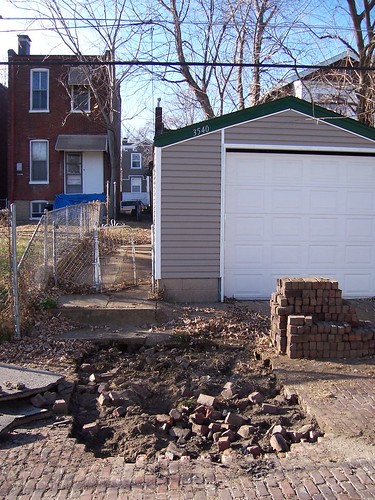
Removing bricks in the alley between the 3500 blocks of Louisiana and Tennessee avenues. Photograph by Eric Bothe.

Meanwhile, the city no longer repairs existing brick alleys. If residents don’t want asphalt, they won’t get any repairs. Also some aldermen use allocations of paving to pave brick alleys with no problems in order to avoid having to return allocations. Schmid has wanted to retain brick alleys for awhile, but could not use existing money to do so. The Department of Streets needs to change its brick alley policy. Meanwhile, the 20th Ward is the first to experiment with restoring brick alleys using a one-time grant of federal stimulus money.

The good news is that federal stimulus money is funding a small but significant project that implements a sustainable approach to retaining brick alley paving. The project fits the goals of the Obama administration in encouraging green practices through federal spending, but it still leaves permanent policy changes up to the city of St. Louis.

Categories
Benton Park West Cherokee Street Gravois Park PRO Collection South St. Louis

1950s Parade Scene, Cherokee at Compton

by Michael R. Allen

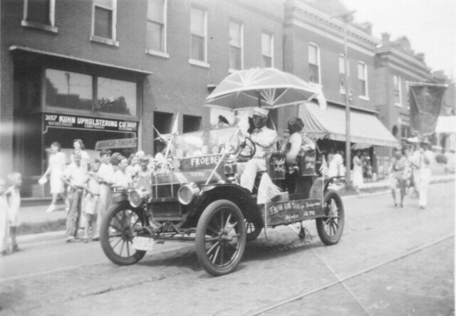
In November, we acquired a collection of 209 black and white amateur photographs taken in and around St. Louis between 1930 and 1980. Most of the photographs are from the 1950s and a large number feature parade scenes. Today we post two taken by the same photographer on the same date showing the intersection of Cherokee and Compton streets in south St. Louis.

A parade heading west on Cherokee Street near Compton Avenue in the 1950s. Photographs from the Preservation Research Office Collection.
The same view today.

The view in the first photograph shows the north side of the 3100 block of Cherokee Street toward the west end.  At right are the buildings now housing Tower Tacos (3149 Cherokee) and Fort Gondo Compound for the Arts (3151).  At left is the larger corner building where Peridot and the StyleHouse, housing clothing purveyors and St. Louis patriots STL Style and Lighthouse Design.  Kuhn Upholstering Company is long gone.  The Fort Gondo and Tower Taco buildings have lost their shaped front parapets.  Overall, however, the view remains remarkably the same.

The parade turned south onto Compton Avenue from Cherokee Street.
The same view today.

The second view looks north on Compton Avenue. Again, little has changed in the fifty-odd years since the parade passed by — just the removal of awnings. Even parades still pass by on Cherokee Street, at least around every Cinco de Mayo.

Categories
Agriculture Gravois Park Shaw South St. Louis Tower Grove East

Chickens in South City

by Michael R. Allen

Sparing readers of chickens coming home platitudes, I will state that there are a lot of chickens in St. Louis city these days. Urban agriculture in the city is becoming more diversified, and many backyard farmers are adding chicken coops with resident hens and roosters. The coops range from formally-designed to organically-built, small to large. Many are made from wooden pieces found in alleys.

On July 11, Travis DeRousse organized the first “St. Louis Chicken Coop Tour” (this is the first by that name, not the first). The tour included eight coops in Shaw, Tower Grove East, Gravois Park, Marine Villa, Benton Park and Dutchtown. The concentration in a relatively small part of south St. Louis suggests that there are dozens of such coops all over the city. Since most coops are low buildings, and most chickens pretty quiet, neighbors may not even realize what is going on next door or down the block. With over 60 people in attendance on the tour, there seems to be strong interest in building more coops and bringing more chickens in the city — which is a return to historic practice, actually.

The first coop on the tour was Greg’s elegant backyard coop in Shaw.  With vergeboards, ornament and a hinged salvaged window, this is a fine work of architecture.

Cara Marie in Tower Grove East built a coop of wood from alleys, with the different pieces almost striated as horizontal siding.

Travis’ own coop in Tower Grove East is a small, neat raised building.  The problem: his dogs shared the backyard, but not for long.  The dogs killed the chickens.  Chickens need to be protected from dogs.  Some coop owners on the tour spoke of how their cats were safe around chickens, and protected them.  Not all cats are created equal, however.

Just one block down the street from Travis, Sara Kate has what was the largest coop of the tour.  Again, the alley salvage craftsmanship shows.  The shed roof is hinged to open for easy access.

I had to leave the tour at the Community Arts and Media Project (CAMP), the fourth stop, but not before peeking in the CAMP coop to see not only a hen but also a duck!  There are certainly lots of possibilities in urban farming.

The contemporary urban coops are just the latest manifestation of chicken-raising in the city.  Old newspapers are full of tales, mostly silly, that illustrate how prevalent chickens were in St. Louis in the 19th and early 20th centuries.  An 1897 article in the St. Louis Post-Dispatch gave a hi-falutin “city farmer” space to describe good practices.  The farmer called for prohibiting chickens in the city so that farms were all-vegetable!

The August 20, 1881 issue of the Post-Dispatch carried the article “The Compton Hill Chickens,” showing that the southsiders of today are really just upholding tradition.  A Mr. Brunaugh of 2744 Lafayette Avenue reported that men were going door to door on Compton Hill trying to sell chickens that they brought along.  The sales ruse included letting the a chicken go, causing a mad dash by the “salesmen” across back yards.  They would capture their hen but also pick up a few others on the way.  “The finest chickens in the city are raised on Compton Hill,” the reporter wrote.

Sometimes chickens led to courtroom drama, too.  The article “Poisoned Fowls Cause of Quarrel” in the October 5, 1904 issue of the Post-Dispatch reported on the curious sudden death of 35 of Mrs. Fox’s chickens.  (There were no limits on number of chickens at that time, and I doubt that today’s chicken farmers have any aspirations to a number as big as 35.)  Mrs. Fox accused next-door neighbor Mrs. Catherine Seher of 2812 Arsenal Street of throwing poisoned bread over the fence.  Justice Kleiber of the Police Court sided with Mrs. Seher, however, after testimony by all parties.  Miss Nellie Seher, daughter of the accused, was a strong witness.  The article notes that Miss Seher “did not use adjectives in her testimony, and was therefore more than ordinarily convincing.”
Categories
Gravois Park Planning South St. Louis Tower Grove South

A Positive Outcome on South Grand

by Michael R. Allen

Both sides of South Grand Avenue between Winnebago and Chippewa Avenues are much improved due to the diligence of concerned citizens taking effective action. Above is a photograph of the Grand South Senior Apartments at the southeast corner of Grand and Winnebago in Gravois Park, completed last year. The building introduces contemporary architecture, adds density and created several storefronts on the site of a mid-century Sears store demolished in 1994. This sort of infill is desirable and practical, and the design is not breathtaking. Why does it warrant an entire essay?

Well, this outcome was far from certain back in 2005. At that time, the site was owned by the Pyramid Companies, which had purchased the Sears site and adjacent city-owned land as part of the Keystone Place project. Although the redevelopment and blighting ordinances for the Keystone Place project outlined mixed-use moderate-density infill on the Sears site and forbade any drive-through commercial, Pyramid suddenly announced a bizarre request for a zoning variance to allow the relocation of the McDonald’s franchise across the street. (The sordid details can be read at Urban Review.)

Pyramid proposed moving McDonald’s to a new drive-through restaurant on the Sears site and acquiring the McDonald’s site for construction of a Grand South Senior Apartments. Keystone Place residents had bought expensive new homes from Pyramid with the assurance of the redevelopment ordinance protected them from fast food across the alley. Gravois Park residents and Alderman Craig Schmid (D-20th) also were riled by the attempt to breach a redevelopment law sought by Pyramid itself just ten years prior.


What ensued was wonderful: neighborhood residents organized against the change to the existing ordinance, and were joined by supporters of sound urban planning from across the city, including young members of the Urban St. Louis Forum. Even though the boundary of his ward was the alley east of the Sears site, Alderman Schmid stood up for his constiuents’ quality of life by opposing the proposed variance. Schmid attended a zoning adjustment hearing and spoke against the changes, eloquently explaining why development just ten feet outside of his ward affected his constituents’ quality of life as much as anything ten feet inside. Alderwoman Jennifer Florida (D-15th), whose ward included the Sears site, chastised Schmid, but his remarks provided cover for her ultimate decision to not support the variance sought by Pyramid.

The rest became history: the citizens of Gravois Park won. But so did Pyramid, and the residents of Tower Grove South to the west. Pyramid built Grand South Senior Apartments following its original redevelopment ordinance (although by the time the first resident moved in, Pyramid was bankrupt), and the pesky McDonald’s went out of business. At the end of 2009, the Mama Pho Vietnamese restauarant — which does not serve food by drive through ordering — opened in the old McDonald’s. This block of South Grand now has a new building and a re-purposed existing building, and no annoying drive-though on either side.

Categories
Gravois Park Hyde Park LRA North St. Louis South St. Louis Storefront Addition

Storefront Additions: Two Inserted Fronts

by Michael R. Allen

All across the city are examples of residential buildings adapted to later commercial use. As neighborhoods changed, so did uses. In early 19th century walking neighborhoods, commercial uses needed to be abundant to serve residents who could not travel far to get food, shoes or a hair cut. Later, after the streetcars gave middle- and working-class residents greater mobility, residential buildings located along street car lines were ripe for commercial use, especially in areas where property values declined because of the new street car lines.

Many examples of the common storefront addition involve the construction of connected one- or two-story buildings in the lawn space of houses and flats. However, in neighborhoods east of Grand, many early converted buildings stood at the sidewalk line. Here, the best way to create commercial space was through the insertion of storefront openings in existing front elevations. Typically, cast iron columns and combined beams would “jack” the new opening in the brick wall. Often, floor levels inside of the building would be altered to draw the shop floor down to sidewalk level from is common position at the head of foundation walls.

Two examples of similar buildings from different neighborhoods illustrate how this practice happened across the city.

3104 Cherokee Street
The flats at 3104 Cherokee Street in Gravois Park date to the middle 1880s, some time after G.M. Hopkins published his atlas of the city in 1883. The side-gabled house is two bays wide, with some decoration evident in the brick cornice. The roof bears a single dormer. Each floor originally was configured as three rooms laid out shotgun style, front to back with no hall. The first floor has obviously been changed, with a storefront opening inserted. The side entrance, angled wall, beam box above the opening and generous window sizes are typical of the period of alteration, the 1890s.

In some ways, the house at 1419 Mallinckrodt Street in Hyde Park is the sister to the house at 3104 Cherokee. Size, fenestration, cornice treatment, roof line and original floor plan match. The building does appear on the 1883 Hopkins atlas. However, the storefront inserted is much different and later than the other. A simple beam heads the store opening, supported by two cast iron columns with Doric capitals forming a central entrance. To each side is brick infill with double-hung wooden windows in segmental arch openings. Now the building is vacant. Broclyn Real Estate Investment of Jefferson City purchased the building from the Land Reutilization Authority in 2006, but has completed no work to date and is close to a Sheriff’s sale for back taxes owed.

Categories
Gravois Park Mayor Slay South St. Louis Tower Grove South

What Does the Mayor Think About McDonald’s?

by Michael R. Allen

At yesterday’s zoning appeal hearing for Pyramid’s McDonald’s relocation project (read more at Urban Review), items introduced into evidence was a purported letter from Mayor Francis Slay supporting the relocation.

One of the people who spoke in favor of an appeal was a woman living on Arkansas Avenue in one of the homes at Keystone Place. She stated that she would never have purchased her home had she known McDonald’s would be moving across the alley from her home. Furthermore, she stated, a couple on her block had placed their home for sale and moved to Richmond Heights in response to the announcement that McDonald’s was coming. (Not too drastic a move given the collusion of alderwoman, powerful developers and lucrative junk food that makes an announcement of a plan tantamount to its approval in the current alderman-driven development system.)

Are we to believe that Mayor Slay, an avowed urbanist and supporter of great density, supports the move of a nuisance business with low lot density to a location where it will lower home values and cause residents to leave new city homes?

Maybe, maybe not. Steve Patterson and others have pointed out that Mayor Slay (along with State Senator Maida Coleman and State Representative Mike Daus) sent his letter to support the construction of senior housing by Pyramid at Grand and Chippewa. That this construction would entail demolition and/or relocation of McDonald’s is obvious; however, the mayor did not expressly support spot zoning for the location at Grand and Winnebago as some people have claimed.

Perhaps the mayor could show leadership in this situation by supporting dense new construction at Grand and Winnebago as well as at Grand and Chippewa. This new construction could include McDonald’s, but a drive-through of any kind would be a detriment to a part of South Grand showing great signs of renewal.

Of course, no mayoral opinion in the world has as much force as the action of an alderman. Until we change the city charter to limit aldermanic control over development, consistent zoning is impossible. That does not excuse the actions of Alderwoman Jennifer Florida, but it does suggest that there is a much deeper problem that needs resolution as soon as possible. (Nay, this problem should have been resolved fifty years ago before our population sunk below 500,000 residents.)

I hope that committed citizens defeat the McDonald’s relocation. And I hope that they keep fighting until they abolish the aldermanic stranglehold on development and zoning that is preventing this city from developing an urban comprehensive zoning plan worthy of a great city.