Categories
Benton Park West Cherokee Street Gravois Park PRO Collection South St. Louis

Cherokee Street Decorated for the Holidays, 1940s

by Michael R. Allen

Undated photograph showing the view down Cherokee Street east from Iowa Avenue. Preservation Research Office Collection.

These two photographs from our collection show two eastward views from the late 1940s down Cherokee Street around Christmas time. Amid the wreaths decorating street lights are an array of shoppers and so many projecting store signs that a count seems impossible. These photographs really make clear how much signs and marquees are visually interesting and worthy parts of the historic built environment, unfortunately now discouraged or effectively outlawed in commercial districts by zoning and local historic district ordinances. (Apparently turning on a stopped historic clock on Cherokee Street is even controversial to the city government, despite the clock’s clear role in the physical fabric.) An exact date for these two photographs, taken on the same roll of film, has not been determined but visual information likely set the year between 1945 and 1950.

Also present is the tension between modes of transportation. The streetcar, whose sign reads “Jefferson Line” in the photograph above, is dominant in the center of the street, but parked automobiles outnumber the streetcars and their rider capacity. Soon they would be the only motor vehicles on Cherokee Street.

Above, we see the Casa Loma Ballroom at left in its present appearance, which dates to reconstruction following a fire in 1940. The Dau Furniture Company marquee at left projects from a lavishly-detailed terra cotta front on the building at 2720 Cherokee (1926, Wedemeyer & Nelson). To its right is part of the former Cherokee Brewery. Almost every building in this scene still remains.

Undated photograph showing the view down Cherokee Street east from Ohio Avenue. Preservation Research Office Collection.

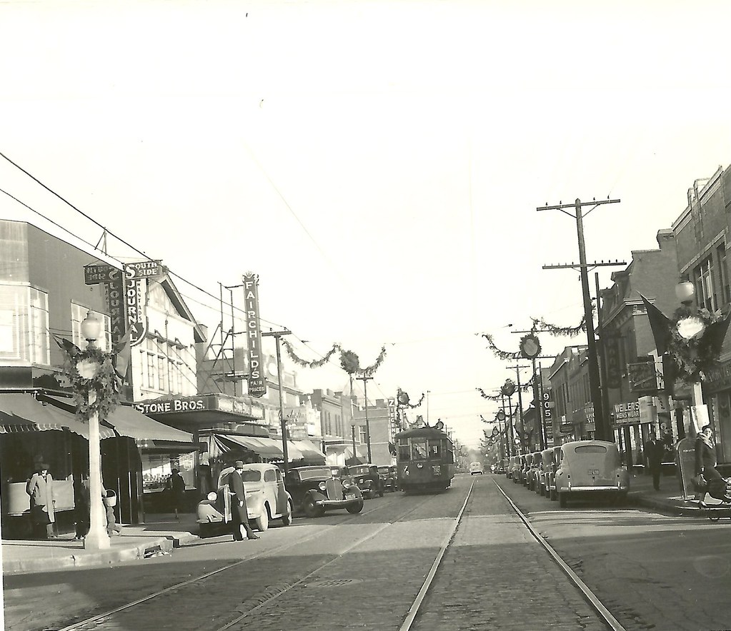
To the east at Ohio Avenue, the view is even more abundant with blade signs touting various stores and companies on Cherokee Street. The northeast corner building, now home to Los Caminos gallery, was the the home of the South Side Journal. Frank X. Bick founded the newspaper in 1932, and it is now part of the Suburban Journals with an office in West County. Other signs include those for Fairchild’s and Stone Bros. attached the a now-vacant building once operated by Anheuser-Busch as the Kaiserhoff, and one in the far background for Ziegenhein Bros. Livery & Undertaking Company. Visible diagonally across the street from Ziegehein Bros.’ building is the sign of 905 Liquors, housed at Cherokee and Texas in what became the home of Globe Drugs. At the time this photograph was taken, murals by artist J.B. Turnbull adorned the walls of that particular location of 905.

Categories
Preservation Board South St. Louis

The Pevely Playhouse Party

by Michael R. Allen

The lobby of the Pevely Dairy plant's main building.

Inside of the Pevely Dairy plant’s office building at the southwest corner of Grand and Chouteau avenues is one of the city’s loveliest factory lobbies. The white tile walls, largely white tile floor and white ceiling make for a gleaming and modern space. Both milk itself and the advances in sanitary dairy plant technology — namely, enameled masonry wall surfaces — are echoed in the design of this space. Here Pevely Dairy maintained a retail operation and soda fountain. The lobby led to offices and other spaces in the building, including a room where a bit of local radio history happened.

From 1953 until 1979, Pevely sponsored one of St. Louis’ last live radio shows, the Pevely Playhouse Party. Charismatic bandleader Russ David hosted the program, which ran on KSD until 1969 and then on WEW for its last decade. During its run, the program broadcast live on weekdays from 12:15 until 2:00 p.m. David and his band, which played jazz and dance music, broadcast from an auditorium inside of the Pevely Dairy office building — a room whose walls were lined with white tile! (See photographs here and here.)

The Pevely Dairy plant's main building. View from the south.

Today the Preservation Board will consider St. Louis University’s appeal of a denied demolition permit for the Pevely plant. The Cultural Resources Office recommends upholding denial of permits to demolish the main building and the smokestack, the two character-defining parts of the plant complex. While the Board deliberates, members will be applying the city’s demolition review ordinance. The Pevely Playhouse Party probably won’t come up in the discussion, nor should it. Still, the Pevely Playhouse Party shows that our buildings have many lives, and are significant to different people for different reasons.

Categories
Adaptive Reuse South St. Louis

SLU Says It Can’t Reuse the Pevely Buildings; Local Designers Beg to Differ

by Lindsey Derrington

Saint Louis University recently stated that it has “studied the Pevely buildings extensively and determined they [do] not meet the needs of a modern health care facility,” effectively justifying its proposed demolition of the entire National Register-listed complex at Grand and Chouteau avenues for a new doctor’s building. Yet the original 1915 Pevely corner building and 1943 Pevely smokestack — the two structures the Pevely Preservation Coalition seeks to preserve — occupy a mere sliver of the university’s nearly 10 acre site between Grand and Chouteau Avenues and 39th and Rutger Streets. This begs the question: “Why?”

Charrette participants working at Landmarks Association's office.

This past Saturday, November 19, the Preservation Research Office, Landmarks Association of St. Louis and nextSTL took on this question with the Pevely Dairy Design Charrette. The four hour charrette proved an incredibly positive event aimed at finding practical solutions for the university to incorporate these historic buildings into its medical campus. The event far exceeded our expectations, with a pool of sixteen diverse participants consisting of architects, graduate students from SLU’s urban planning program, a mechanical engineer, and even a SLU doctor weighing in.

After a thorough discussion of the site’s dimensions, SLU’s extensive landholdings in the area, and the university’s probable needs, participants subdivided into four groups. Each focused on a different approach, including converting the corner building into doctors’ offices with a larger modern addition, adapting it into market-rate housing and ancillary facilities for the medical school, finding additional on-site locations for new buildings, and generating an overall site plan to connect this corner to the rest of the university.

Discussing ideas at the charrette.

The charrette was characterized by the matter-of-fact study that its designers bring to the workplace and classroom on a regular basis. Idealistic, or even hopeful rhetoric was wholly absent, because it turns out that this design “problem” is no problem at all. Each group presented multiple scenarios of how to preserve these buildings while still accommodating the university’s needs. The take-away was that the task is almost too easy, and that given more time, even more solutions could be found.

Their plans will be presented at the Preservation Board meeting on Monday, November 28. Hopefully board members will see past SLU’s influence and political clout to what is so clearly apparent: these structures can and should be incorporated into the university’s larger medical campus to serve patients, doctors, and students in a manner that enhances the built environment rather than destroys it.

Categories
Infrastructure South St. Louis Streets Tower Grove South

A “New” Brick Alley in Tower Grove South

by Michael R. Allen

On Friday I participated in a mobile workshop on the South Grand business district that was part of the annual conference American Planning Association Missouri Chapter. The workshop started with a driving tour from the Chase Park Plaza (conference venue) that included Kingshighway, Southwest Garden, Shaw and Tower Grove Park. After the tour, over lunch at Mojo, participants heard about area history from planner and historian Mark Abbott and the current streetscape project from Rachel Witt of the South Grand Community Improvement District and Mary Grace Lewandowski of the East-West Gateway Council of Governments.

Then the group headed out for a tour of South Grand guided by Andrew, Rachel and myself. While many excellent buildings were included alongside the quickly-nearing-completion improvements to Grand’s sidewalks, the stand-out of the tour was an alley. That is right — the tour ended at the alley between Humphrey and Utah streets west of Grand.

View west from Grand Avenue of the alley south of Humphrey Street.

The reason for including the alley, as Andrew Murray eloquently stated, was that it demonstrated very basic principles of sustainability in the built environment. Alleys are instruments of vehicular utility, and their presence in St. Louis is taken for granted. However, many are in rough shape because their paving bricks have been layered with asphalt pavings. City alleys often settle with the bricks, and become uneven and difficult to maintain. Meanwhile, they deflect water onto parking pads, into garages and onto streets.

Andrew Murray discusses the brick alley project with tour participants.

This alley in Tower Grove South has been returned to sound condition in a way that is both historically and ecologically informed. Alderwoman Jennifer Florida (D-15) and the Streets Department found funds to rebuild the alley by paving it with historic paving bricks, gloriously purple-red and gently chipped through decades of urban life, reclaimed from the alley itself. Set on a new substrate, the bricks are level but also are water permeable. The only deviation from historic conditions is that the design included a concrete perimeter to buffer the paving from existing outbuildings and curbs.

This alley not only is “green” but also reflects its historic character by bringing its original paving material back to the surface. The result is durable and attractive, and maintenance simple. Sustainability need not be a headlong rush into trendy new building technology, when time-proven materials and methods are at hand. Our tour ended by reminding participants that existing infrastructure already embodies today’s planning standards. Modular water-permeable paving? We already did that — one hundred years ago.

Categories
South St. Louis Southampton Theaters

Avalon Theater: Price Reduced

The Avalon as it appeared in August 2009.

The listing price for the Art Deco Avalon Theater at 4225 S. Kingshighway has dropped to $249,900. View the listing here.

Suffering from deterioration since closing in 1999, the 647-seat Avalon is one of the city’s few remaining neighborhood single-screen theaters and part of our early modern past. The Avalon was built in 1937 and designed by A.F. and Arthur Stauder, a prolific father-and-son firm that designed many modern churches in St. Louis (St. Gabriel the Archangel, St. Nicholas).

Categories
Clearance Infrastructure JNEM PRO Collection Riverfront South St. Louis Urban Renewal Era

Photographing the Changing Face of St. Louis

by Christina Carlson

I recently had the opportunity to digitize several photographs for the Preservation Research Office spanning from the 1930s to the 1980s. The photos consisted primarily of pictures of historic buildings and other structures in St. Louis, but also included were snapshots of parades, fairs and local people. Although many of the photos were of great interest– revealing buildings, people and spaces now forgotten — a few in particular caught my attention.

The Old Cathedral amid riverfront clearance around 1942. Photographer unknown.

At first glance this snapshot appeared to me as nothing out of the ordinary, simply another picture of the substantial efforts at demolition which took place in mid-century St. Louis. However, on a second look I recognized the iconic nature of this photo. The church in the center of frame is The Basilica of St. Louis, King of France, which sits adjacent to the Gateway Arch ground. I realized that this image captures the moment of destruction for a large swath of the riverfront area which began in 1939 and ended by 1961. Despite the conjecture of many who saw the riverfront area as a vital, ethnically and cultural diverse area, demolition of some of the oldest buildings in St. Louis was approved in 1939. In a twist of irony, much of the Eastern portion of the city was destructed to make way for a memorial to Westward expansion.[1]

Construction of the ramps connecting Interstate 44 to Interstate 55, circa 1964. The City Hospital is in the background. Photographer unknown.

Another photo I noted was one on the opposite end of the spectrum, as it portrayed the construction of the lanes of Interstate 44 where it merges into Interstate 55 south of downtown St. Louis. This image evokes a different moment in the city’s history, one in which it suddenly became much easier for those in the rapidly expanding suburbs to reach downtown, and to leave it. Although the history of suburban development in the post-war years is well known, the story in St. Louis was particularly evident. As the population shifted outward, many buildings within the city were demolished, leaving in their wake parking spaces and empty lots.

Side by side, these two images powerfully convey prominent themes in the history of St. Louis: the destruction of older, more diverse districts and the construction of vast networks of suburbs, supported by the presence of major freeways bypassing downtown. Although there are a variety of themes present in the photographs I digitized – family ties, segregation, religion, wealth, poverty – none were so prevalent as the drastic restructuring of the face of the urban landscape in St. Louis in the middle of the twentieth century.

Categories
Industrial Buildings Kosciusko Mid-Century Modern South St. Louis Urban Renewal Era

The Nooter Corporation Building: Urban Renewal, Atomic Power and Mid-Century Modernism

by Michael R. Allen

Looking at the Nooter Corporation Building from the south.

Some of the context for the history of the Nooter Corporation Building is found in my earlier article “A Brief History of the Kosciusko Urban Renewal Area” (June 19, 2011).

The modest two-story modernist office box located at 1400 S. Third Street south of downtown doesn’t evince its deep and important connections with historical forces as powerful as the development of atomic energy in the United States, St. Louis’ postwar effort to retain its manufacturing workforce and the mid-century modern architectural practice of a renowned engineering firm. Yet the red brick Nooter Corporation Building marks the intersection of these forces, at least through the administration of a company at the forefront of them. Here was the building that housed not the fabricators but the conjurers — those who dreamed of fitting an old boiler company into the mid-century mission of transforming America into modern nation.

View southeast toward the building in 2007. The Nooter Corporation lettering has been removed.

Following World War II, the Nooter Corporation entered into a rapid period of growth through involvement as a supplier and erector of process vessels to the emergent nuclear power industry as well as the established chemical, petroleum, food and defense industries. Nooter embarked on a major expansion of its plant in 1947 and by 1957 the corporation decided to build a new corporate headquarters suitable for its prominence. In 1959, administrative and engineering offices moved to the building.

From this office, engineers devised plans for the construction of a reactor vessel for the world’s first atomic energy plant and the world’s first use of titanium, tantalum and zirconium in reactive vessel construction. From 1964 through 1973, Nooter successfully applied for 13 patents, marking a major period of invention for the company. Nooter had not applied for a patent since 1954 and would not apply again until 1978. So the harmless little building in a tired old part of an ancient American city was actually an intellectual powerhouse from which ideas about new ways to make energy were born. Perhaps that is not surprising, since our buildings are often quiet keepers of great stories that may not initially seem to be linked to our own daily lives.

Categories
Fire South St. Louis Tower Grove South

If The Front Wall Remains…

by Michael R. Allen

View looking southeast toward the building.

What a way to start a fire, what a way to break it in
Your kiss could have killed me, baby
If it were not for the rain

Scout Niblett ft. Bonnie Prince Billy, “Kiss” (This Fool Can Die Now, 2007)

Did a fire destroy the commercial building on South Kingshighway two doors north from the Royale, or did a fire bring into being the birth of a new building? Time will tell. Surely the ashen and roofless wreck, with side wall fallen to let the world gaze into a tangle of charred building fiber, evokes some bit of hopelessness. Without a roof, a building is still a building. Without four walls and horizontal structural members, a building becomes rubble.

View looking southwest from the alley.

Or does it? Looking out across the remnant body of what was a fine but not remarkable stock-from-the-catalog hydraulic press brick and terra cotta essay in the revival style, my eye cannot see total loss. I look at that front wall, that strong and still intact front wall, and I see the first wall of the next building. Now this building was not built through completed walls laid up in detail one by one, but through the slow and integrated rise of building material from beneath the soil up to the sky. The burned building’s front wall was never meant to stand isolated from the other brick walls that bound together in architectural union.

Yet there is a basic fact: that front wall is solid, attractive and integral to that street wall’s humane relationship with the sidewalk. While there is a car lot immediately to the north, and the neighboring Modern Kitchens and Baths has an inset parking lot unmitigated in its utility, this single building provides a humane and urban link between a corner tavern and Tower Grove Park. Although Kingshighway south of Arsenal street has a schizophrenic street wall, and offers few spots of continuous urban character to the pedestrian, this little place works. Here there is a place where a person can walk and feel that there is some vital link between this place and the living city around. Those places are sadly few and far between on St. Louis’ major commercial streets, and should be categorically protected and constantly expanded. The only reason we don’t have more places like this is our casual use of the wrecking ball, and our lack of zoning based on quality of life.

Should this city want to ensure our future is one in which the name “St. Louis” could pass through the lips of those people who value urban places teeming with the lifeblood of commerce and culture, we would never let a front wall be torn down after a fire unless it fell for a greater replacement. We should pass an ordinance preventing demolition of commercial buildings that hug the sidewalk with storefronts unless like replacement follows. Otherwise we will continue to be a city of great residential neighborhoods isolated through dismal expanses of arterial streets.

Should the building owner or the Building Commissioner protest that preserving this front wall on Kingshighway is an impossible feat, or a difficult one, their cries should be dismissed. This is a solid masonry wall, and its stabilization and integration into a new building is an easy task. At least, having seen such work as a matter of course in cities as diverse as Boston and Louisville, it seems like a city as great as ours can rise to a small job like this — a small job that serves the greater good of making a place where people enjoy walking, talking and conducting commerce.

Although our eyes’ gaze may be stubborn and myopic at times, we should look upon this front wall on Kingshighway not as a ruin but as something we can use. We should rejoice that the fire consumed not the most vital and urbane part of this building, and we should strive to build something that carries that vitality forward to the future. Sometimes it does seem that a kiss — the kiss of greatness — would kill this city, but deep down we know that the kiss could end generations of that far more fatal feeling of complacency. That damn front wall didn’t build itself.

Categories
South St. Louis

Three South Side Buildings

by Michael R. Allen

A few weeks ago Thomas Crone’s excellent The South Side of Luck posted a video of me talking about three south side buildings. Crone’s instructions: find “one that was interesting and safe; one that was interesting and undergoing some type of facelift; and one that was interesting and in danger of going away.”

After some thought and elimination of dozens of possibilities — ranging from City Hospital to that little abandoned stone house at Steins and Water streets — I chose the Avalon Theater (in danger), the St. Louis Hills Office Center (“some type of facelift” indeed) and a minor Harris Armstrong commission at 3524 Gravois (interesting).

All I did was talk; Crone was producer, Brandon McLaughlin did the audio, and director Tyler DePerro filmed it all. Although we dodged gloomy weather that seems hard to believe on this 100-degree day, the shoot is a neat little document. Check it out. The get more tales — some also told through moving pictures — of the city’s south side over at The South Side of Luck.

Categories
Kosciusko LCRA South St. Louis

A Brief History of the Kosciusko Urban Renewal Area

by Michael R. Allen

In 1947, the City of St. Louis published as a guiding document a Comprehensive Plan that called for bringing the city’s land use and zoning codes up to then-modern standards. Among the recommendations of the plan were the clearance and rebuilding of several large, older sections of St. Louis, including most of the historic Soulard and Kosciusko districts just south of downtown. In 1951, the Board of Aldermen took a dramatic step toward large-scale urban renewal projects by creating the Land Clearance for Redevelopment Authority (LCRA) “to undertake the acquisition, relocation, demolition, and site improvements of the urban renewal areas. . . which needed Federal assistance.”

The C. Hager & Sons Hinge Company Buildinga at 139 Victor Street, listed in the National Register of Historic Places, are among the few buildings not demolished as part of the Kosciusko clearance project.

Governed by a five-person board appointed by the Mayor, LCRA became the means for a variety of ends in redevelopment. At the end of 1953, LCRA attracted a new Executive Director, Charles L. Farris, former Deputy Director of the Federal Slum Clearance and Urban Redevelopment program, Housing and Home Finance Agency, Washington D.C., Farris previously had been appointed by LCRA Board of Commissioners on the recommendation of new Mayor Raymond R. Tucker.

Kosciusko around Russell Boulevard with Broadway and the Soulard neighborhood at left. View is looking north.

Under Farris, LCRA moved rapidly to implement the redevelopment recommendations of the 1947 plan. One endeavor was the clearance of the Kosciusko district, which city planners envisioned as an appropriate district for industrial expansion. Kosciusko was a dense, somewhat-rundown assembly of 19th century brick commercial buildings and tenements as well as industrial facilities that had sprung up on the riverfront and expanded into the neighborhood. Kosciusko had many social and physical ties to the adjacent Soulard area, and, in fact, architecturally was greatly similar. Like Soulard, the 2,941 residents of Kosciusko were predominantly poor. The housing stock was substandard, and the industries were land-locked with little alternatives except moving out of the district.