Categories
Streets

The Last Full Moon Fiasco

by Michael R. Allen

Henry Ziegenhein served as mayor of St. Louis from 1897 until 1901. He is best known for his quip to the St. Louis Post-Dispatch in 1900 during his delay in signing a street lighting contract. With the city was dark for weeks, the mayor told the press: “We’ve got a moon yet, ain’t it?”

Such a proclamation was far from one mayor’s provincial mindset. In 1939, St. Louis city government actually turned off street lights early and shut off all park lights to balance the city budget.

No telling if Ziegenhein would approve, but he seems to share a historic lunar conviction with the posse of bicyclists who rode its last Full Moon Fiasco last night. If you don’t know what FBC stands for, think about it. Coincidentally, FBC’s (celebrated) founders included Peat Henry while one-term mayor Ziegenhein was known (derisively) as “Uncle Henry.”

Categories
Parks South St. Louis Southwest Garden Streets

Kingshighway Needs a Crosswalk at Tower Grove Park

by Michael R. Allen

In 1902, St. Louis Mayor Rolla Wells appointed a commission to make recommendations for establishing a circumferential boulevard. The commission, led by landscape architect George Kessler, delivered a report calling for a wide and well-landscaped road connecting Carondelet, Tower Grove, Forest and O’Fallon parks, the major north side cemeteries and the north and south riverfront areas. Wells signed an ordinance in 1907 enacting the plan, but its realization was never full. Parts of the Kingshighway system exist, such as the southeast extension along Christy and Holly Hills boulevards as well as the northern memorial parkway from Martin Luther King Drive to Penrose Park.

Yet where Kingshighway was partially or never realized, the road is noisy, sometimes ugly and difficult to traverse on foot. Alas, that is the case at Tower Grove Park. There are traffic signals at Magnolia and Arsenal streets, but no intervening signal or stop sign for the rest of the western length of the park. Residents of Southwest Garden to the west have a tough time walking into Tower Grove Park.

Categories
Infrastructure South St. Louis Streets Tower Grove South

A “New” Brick Alley in Tower Grove South

by Michael R. Allen

On Friday I participated in a mobile workshop on the South Grand business district that was part of the annual conference American Planning Association Missouri Chapter. The workshop started with a driving tour from the Chase Park Plaza (conference venue) that included Kingshighway, Southwest Garden, Shaw and Tower Grove Park. After the tour, over lunch at Mojo, participants heard about area history from planner and historian Mark Abbott and the current streetscape project from Rachel Witt of the South Grand Community Improvement District and Mary Grace Lewandowski of the East-West Gateway Council of Governments.

Then the group headed out for a tour of South Grand guided by Andrew, Rachel and myself. While many excellent buildings were included alongside the quickly-nearing-completion improvements to Grand’s sidewalks, the stand-out of the tour was an alley. That is right — the tour ended at the alley between Humphrey and Utah streets west of Grand.

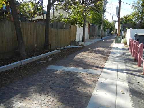
View west from Grand Avenue of the alley south of Humphrey Street.

The reason for including the alley, as Andrew Murray eloquently stated, was that it demonstrated very basic principles of sustainability in the built environment. Alleys are instruments of vehicular utility, and their presence in St. Louis is taken for granted. However, many are in rough shape because their paving bricks have been layered with asphalt pavings. City alleys often settle with the bricks, and become uneven and difficult to maintain. Meanwhile, they deflect water onto parking pads, into garages and onto streets.

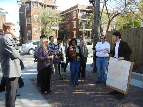
Andrew Murray discusses the brick alley project with tour participants.

This alley in Tower Grove South has been returned to sound condition in a way that is both historically and ecologically informed. Alderwoman Jennifer Florida (D-15) and the Streets Department found funds to rebuild the alley by paving it with historic paving bricks, gloriously purple-red and gently chipped through decades of urban life, reclaimed from the alley itself. Set on a new substrate, the bricks are level but also are water permeable. The only deviation from historic conditions is that the design included a concrete perimeter to buffer the paving from existing outbuildings and curbs.

This alley not only is “green” but also reflects its historic character by bringing its original paving material back to the surface. The result is durable and attractive, and maintenance simple. Sustainability need not be a headlong rush into trendy new building technology, when time-proven materials and methods are at hand. Our tour ended by reminding participants that existing infrastructure already embodies today’s planning standards. Modular water-permeable paving? We already did that — one hundred years ago.

Categories
Infrastructure North St. Louis O'Fallon Streets

Brick Alleys in the O’Fallon Neighborhood

As the Preservation Research Office team conducts its architectural survey of the O’Fallon neighborhood of north St. Louis, it has noted the presence of several intact historic brick alleys. Paved with “paver” bricks made by local manufacturers in the last 19th and early 20th centuries before the rise of concrete street paving, brick alleys are part of the built landscape of the neighborhood — and the city. Unfortunately brick alleys have disappeared along with brick streets. O’Fallon is fortunate to have some remaining in good repair. Those shown here can be found in the H-shaped alley network between Fair, Green Lea, Clay and Penrose streets.

Brick alley running north between Penrose Street and Green Lea Place just west of Clay Avenue.
Brick alley running north from Penrose Street to Green Lea Place just east of Fair Avenue.
Categories
Midtown Streets

Vandeventer, Your Granite is Showing

by Michael R. Allen

While heading north on Vandeventer Avenue today we spotted an open cut just south of Lindell Boulevard, in which workers were repairing pipes. The cross-section of street looked like this:

One can easily see a layer of red Missouri granite paving blocks under the asphalt. Granite paving like this came into use in St. Louis during the early 1880s.  Peter Vandeventer opened the Vandeventer Place addition in 1870, and the street was laid out then from Cass Avenue on the north to Lindell Boulevard on the south.  The southern extension between Lindell Boulevard and Old Manchester Road (now also called Vandeventer) is shown on Pitzman’s 1878 atlas of St. Louis County and City.

Vandeventer likely was unpaved at the start, so the granite blocks may be the street’s original paving.  Judging from what is evident today, they are likely intact and buried directly under the asphalt.  We are never very far from our roots, are we?

Categories
Historic Preservation North St. Louis Old North Streets

14th Street Mall: Almost History

Here’s the current view from St. Louis Avenue looking south down the two commercial blocks of 14th Street that once composed the “14th Street Mall.” Sidewalks nearly done: check. Street under construction: check. Reopening of 14th Street by the fall: check and double check.

Categories
Downtown Streets

16th Street: Open for Business

by Michael R. Allen

Here is 16th Street looking south across Delmar Boulevard. This may seem a mundane site to serve as a subject for a short article, but it is noteworthy for one reason: the stupid gates that blocked 16th Street are gone. The gates have been gone for a few years now, but for a long time gates blocked the sidewalks and street here, cutting off through traffic of all kinds between Delmar and Dr. Martin Luther King Boulevard.

Residents of Carr Square couldn’t pass through walking to downtown, downtown residents could not pass through walking north. Cars couldn’t pass from Washington up to MLK or vice versa. Parking spots on this block were ridiculous on weekends, when they sat unused while City Museum patrons circles the block looking for spaces. Street grids are systems, and no disruption is casual to users. Like most closures in St. Louis, this closure had no apparent reason, other than to serve some whim of a tenant in one of the warehouses.

No doubt some well-meaning alderman put forth a bill to vacate the right-of way here, and no doubt that alderman was wrong to do so. Streets, sidewalks and alleys are public spaces that should be closed only in rare circumstances — and business loading, parking and “security” are insufficient reasons to alter the flow of the life-blood of pedestrians and motorists across the city. Another alderman reversed the closure, and the life of the grid has returned.

If there’s such a closure in your ward, call your alderman and get it taken out! Gates and blockades can be removed as easily as they are installed.

Categories
North St. Louis Old North Streets

Street and Sidewalk Work Started on 14th Street

by Michael R. Allen

Looking north on 14th Street from Warren Street.

On Friday, after long-awaited approval from the Missouri Department of Transportation, street and sidewalk work began on the two blocks of 14th Street once known as the 14th Street Mall. Work should be completed by the fall. Building rehabilitation is nearly complete. Read more on What’s New in Old North.

Categories
I-70 Removal Mass Transit Mid-Century Modern Streets

Vintage Streetcar Photographs Show Mid-Century St. Louis

This week St. Louisan extraordinaire Jeff Vines discovered an online cache of 120 photographs of St. Louis Public Service Company trolley cars taken between 1954 and 1961. A few photographs from the 1980s are included.

The images of the cars in their vintage red, white and tan color scheme are fabulous. Yet the photographs also capture views of the city long lost, change or, in a few cases, preserved. The old Grand Avenue viaduct, its replacement soon to be replaced, features in many of the photographs in use adn under demolition. Other locations include the South Broadway car barn (now site of Carnahan Middle School), the Midtown skyline (remarkably unchanged), Maplewood, University City and Flynn Park, Washington Avenue from the Eads Bridge street car turn-around to 15th Street, rural Creve Couer, downtown St. Charles, and McKnight Road.

The photographs of the vicinity of the Eads Bridge and Washington Avenue include shots of the piers for the modern elevated lanes of I-70, now seen as likely to be removed in most of our life times.

Categories
Forest Park Southeast Housing Streets

Thoughts on the Proposed Adams Grove Infill Project

by Michael R. Allen

Alex Ihnen has reported the his St. Louis Urban Workshop blog that a substantial new scattered-site infill housing project is in the works for part of Forest Park Southeast. Specifically, the Regional Housing and Community Development Alliance hopes to build 40 new houses on and around Norfolk and Vista avenues west of Newstead. These are some the neighborhood’s roughest blocks in its most neglected portion, the area south of Manchester Avenue known as Adams Grove. Adams Grove was platted in 1875 and is the oldest part of Forest Park Southeast, but long has lagged behind the northern section of the neighborhood in development efforts.

Readers may recall that in 2006, these blocks were targeted by the Forest Park Southeast Development Corporation during a wide round of demolition that took down over 30 buildings across the neighborhood. The Preservation Board approved demolition permits for one building on Norfolk and eight buildings on Vista.

One of the worst aspects of this round of demolition was the wholesale removal of vacant frame houses like the row shown here. These six houses stood from 4452-4462 Vista Avenue. Proponents of demolition argued that the houses were too small for people’s demands, and that wide clearance would allow for a large-scale new housing effort.

While the large-scale infill project is welcome fulfillment of the promises that the Development Corporation made in support of demolition, there remains some bittersweet irony that the houses now proposed for construction are small, one-story homes like those rejected as unfit for housing needs. Make no mistake, though — the size of the proposed infill is perfect for the area and the housing needs. That’s why some of us opposed demolishing the frame shotgun houses that also could have served those needs.

The wide demolition in 2006 could lead to two other losses, one of which is the prominent two-story brick corner building at Newstead and Vista that recent was being rehabilitated. Getting remaining buildings listed in the National Register of Historic Places to attain historic rehab tax credits might be difficult, although certainly not impossible. The demolitions are tentative, though, and could be avoidable.

One problem for these specific block of Adams Grove are the cul-de-sac street closures on the western end. These closures are partly responsible for the decline of the building stock in this area. Placement of the closures at an unsightly and moribund stretch of Taylor Avenue has compounded the ill effects. The “dead ends” on Swan, Norfolk and Vista avenues attract enough criminal activity to deserve the term.

Here’s the closure on Norfolk:

And this is Vista:

The Vista closure even has large evergreen trees that close off the sight lines of the street. To make these blocks safe and desirable places to live, the closures must be removed and Taylor must be improved. I want very much for the infill project to succeed, because Adams Grove needs major development. That development must address the circulation problem to succeed.