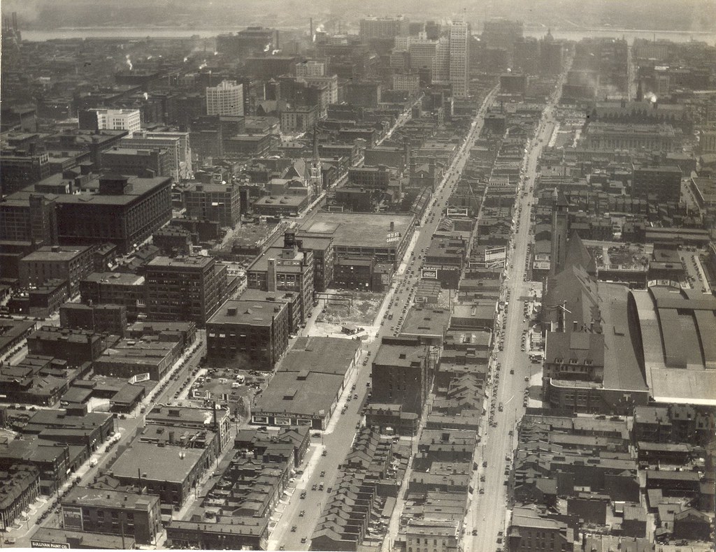
This amateur photograph may be out of focus, but its view is monumental: the Depression-era skyline of St. Louis, would-be metropolis of the Midwest. Looking north up the Twelfth Street (now Tucker Boulevard) viaduct over the Mill Creek Valley railyards, the photograph captures the hustle and bustle unfolding against the backdrop of the city’s earnest skyline. The date of this image is unknown, but it includes the Terminal Railroad Association’s Mart Building (1931; Preston J. Bradshaw, architect) and the Civil Courts Building (1930; Klipstein & Rathmann, architects for the Plaza Commission). At left is a glimpse of the J.C. Penney Warehouse (1928; T.P. Barnett & J.F. Miller, architects) and at right, obscured behind the Chevrolet billboard is the top of the Southwestern Bell Building (1925; Mauran Russell & Crowell with I.R. Timlin, architects).
Although these commercial and civic attempts to reach the sky were modest for the era, they are nonetheless beautiful and part of a fully urban scene. In the foreground, the viaduct receives repairs from a crew while the streetcar advances southward. Out of the frame, further south on Twelfth Street, would be some of the most densely populated blocks of south St. Louis. Although the city was suffering alongside the rest of the nation, its sense of purpose would not wane.
Our intern Christina Carlson digitized the photograph used here.
This is the second part of a nine-part series on the evolution of the Gateway Mall, that ribbon of park space that runs between Market and Chestnut streets and from the Jefferson National Expansion memorial westward to Twenty-Second Street downtown. This article began its life as a lecture that I delivered to the Friends of Tower Grove Park on February 3, 2008, and was published in its entirety in the NewsLetter of the Society of Architectural Historians, Missouri Valley chapter in Spring 2011.
Landscape architect George Kessler was one of the chief theorists of rationalist urban planning. Kessler designed the 1904 World’s Fair landscape, which was a masterpiece of orderly expansive views. Kessler had little use for formal gardens or wildness; he favored large neat orderly lawns defined by imposing trees or dramatized by the placement of ornate buildings. Rather than emphasize the delights of natural flora, Kessler underscored the beauty of a total landscape. At the Louisiana Purchase Exposition of 1904, this landscape included ornate Beaux Arts buildings. Here was a mirror of the early ideal of the Gateway Mall — orderly formal landscape contained by monumental public buildings. Mayor Rolla Wells was a supporter of Kessler and put him to work on several urban planning projects, including a plan for Kingshighway that envisioned the road as a true parkway.
The site of the future Gateway Mall circa 1928, looking east from about 21st Street, with Union Station and Market Street on the right. (City Plan Commission photograph.)
In the absence of an official city government planning apparatus, the reform-minded Civic League created a City Plan Committees to undertake the first comprehensive city plan in 1905. The Plan Committees included numerous prominent businessmen, political leaders, architects and engineers. The Committee published the city’s first Comprehensive Plan in 1907. The Committee reported that there was one acre of park for every 96 people living west of Grand and one acre for every 1,871 between Grand and the river. The Committee found this density undesirable and recommended creating additional park space through clearance. One-hundred years later, after decades of demolition in the central core of our city has destroyed entire neighborhoods and rendered others dysfunctional, the Committee’s plan seems short-sighted. The difference recorded in the number of park acres east and west of Grand did not necessarily indicate any real difference in quality of life. It simply recorded a greater building density east of Grand in the oldest walking neighborhoods of the city. Later city planners would to appreciate the boost high building density gives to fostering strong community ties, creating safe streets, creating vital commercial districts, and raising property values.
This building at 1403 Pine Street, photographed in the 1930s, is typical of the housing stock planners wanted to remove from western downtown.(Preservation Research Office Collection.)
Today we publish the first part of a nine-part series on the evolution of the Gateway Mall, that ribbon of park space that runs between Market and Chestnut streets and from the Jefferson National Expansion memorial westward to Twenty-Second Street downtown. This article began its life as a lecture that I delivered to the Friends of Tower Grove Park on February 3, 2008, and was published in its entirety in the NewsLetter of the Society of Architectural Historians, Missouri Valley chapter in Spring 2011.
Looking east down the Gateway Mall in 1970. (Collection of Landmarks Association of St. Louis.)
Let’s review: The Gateway Mall is a line of parks that runs between Chestnut and Market Streets from Memorial Drive west to 22nd Street. Right?
Other than the handful of destination blocks, few St. Louisans could readily identify the visual characteristics that define the Gateway Mall. Descriptions of the mall, like the one that I just offered, typically revert to geography. The mall’s boundaries are street names. The mall’s identity lies in what surrounds it, and not in inherent qualities that the user of Forest or Tower Grove parks offers to someone unfamiliar with those spaces. Reliance on a geographic description of the Gateway Mall is quite gentle, because to enumerate what the mall contains hardly portrays an attractive green space.
Can you spot the park mall in this aerial phtograph of downtown? (Photograph by Rob Powers, builtstlouis.net, circa 2004.)
We have a jumble of mismatched blocks, from the passive formal parks across the street from City Hall to the postmodern ruins of Kiener Plaza to the sunken garden between the Old Courthouse and the Arch. We have monumental blocks like Aloe Plaza and the Richard Serra sculpture block that lose all of the drama of monumentality by being placed alongside interceding dull blocks of dead park space. We have interruptions like the Civil Courts and the Old Courthouse, a fairly pleasant juxtaposition if only there were not a poorly-wrought 1980s standing between the two. Some blocks are wide, some are narrow. Some are standard length and others form smaller super-blocks. The whole mall is almost hinged around the Civil Courts building, where Market Street bends slightly southwest. That bend precludes true symmetry.
The view east from 20th Street. Here the view is pretty much coherent.
So what do we have? Currently, we have a green space running through downtown named the Gateway Mall. Is it a park? Landscape historian Tom Turner writes in his book City as Landscape: “If the space has no boundary, it should not be called a park. And if it has a boundary, the boundary should have a defined purpose.”
The Gateway Mall has no historic boundary. That is, its boundaries have shifted under various plans. Originally, it would have extended between Grand and 12th (now Tucker). Later plans had it extending east to meet the Arch. Nowadays, it does start at the western edge of the Arch grounds but ends rather haphazardly past 21st street. The terminus is a chain link fence separating and irregularly shaped block from a highway ramp.
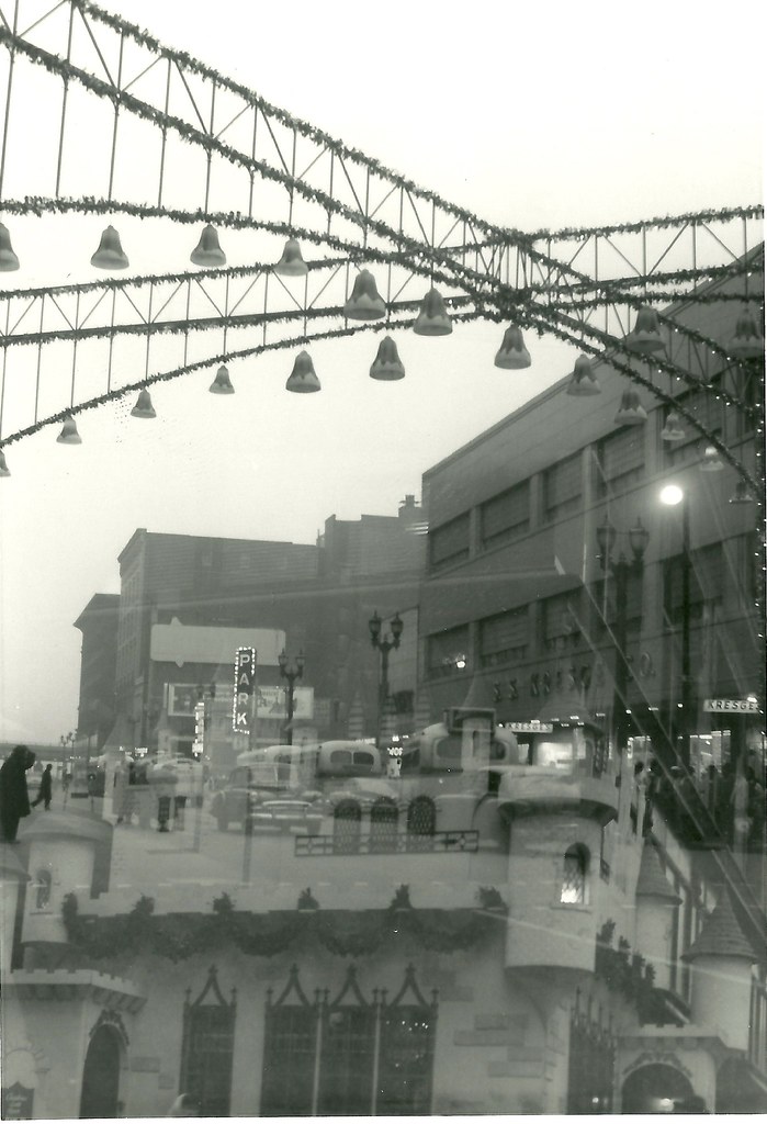
This photograph captures the reflection of a Christmas castle and part of the Stix, Baer & Fuller Grand Leader store building (1906, Mauran Russell & Garden; 1919, Mauran, Russell & Crowell) spread across Washington Avenue. The view is looking southeast from Sixth Street, and the procession of buildings on the south side of the street is pretty clear despite the visual accident. The view down Washington is terminated by the elevated lanes of Interstate 70, completed in 1964, so the date of this photograph — unmarked and unrecorded — is 1964.
At right, we have the S.S. Kresge store at Broadway and Washington, which opened in its streamline-slipcovered building 1939. Across the street and to the east is a surface parking lot where the B. Nugent & Brother Dry Goods Store had stood until just a few years prior. That lot gets a view of the side wall of the J. Kennard & Sons Carpet Company Building (1901, Isaac Taylor), which otherwise presented elevations articulated and adorned in the manner of the Italian Renaissance. That building would later be expanded by the Edison Brothers Company after they moved their headquarters there. The Nugent site would give rise to the studious but dour modernist mass of the 500 Broadway Building (Smith-Entzeroth, 1970).
Further east, this photograph includes a rare glimpse of a seven-story commercial building that once stood at the southeast corner of Fourth and Washington that was once home to Trorlicht-Duncker Carpet Company. That building was demolished in 1966 to make way for the northernmost of the three-story Mansion House Center office buildings (Schwarz & Van Hoefen, 1967).
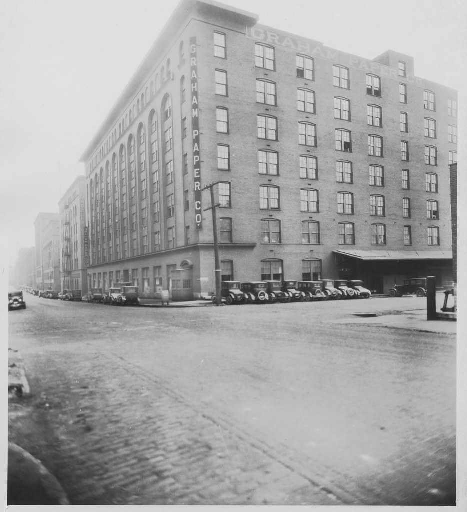
The Graham Paper Company Building (now known as Cupples Station Building 7) shown in a photograph in the Station Masters files in the collection of the St. Louis Building Arts Foundation.
On November 9, Kevin McGowan applied for a demolition permit for Building 7 at Cupples Station (originally the Graham Paper Company Building). The city’s Cultural Resources Office denied the permit, and McGowan appealed the denial to the Preservation Board. The appeal will be considered at the Board’s meeting on November 28. Since it is an appeal, the matter requires a quorum of Preservation Board members to be present for any vote. (Currently eight of the nine spots are filled.)
On appeal, the threshold for approval of demolition is high. The Preservation Board will face arguments from McGowan that the building cannot be stabilized at a reasonable cost, including his recent assertion that demolition costs $2 million less than stabilization. Board members might hear that the building was far too gone to be saved when McGowan originally purchased it in 2004, despite the fact that his company purchased it for rehabilitation.
The burden of proof rests with the appellant, so Preservation Board members need to dig deep in learning the facts. What was the condition of the roof and collapsed structure when McGowan purchased it? What measures has his company taken to prevent the spread of damage? How many building code violations have been found, and when, and did McGowan’s company ever take steps to comply with the code? Have there been offers from other developers to purchase the building, and, if so, why has a sale not taken place? And, of course: How much money does stabilization really cost, and can it be phased?
Cupples Station is an architectural treasure that has faced countless threats over the years. In fact, over half of its original warehouses are gone, leaving just eight remaining. Yet the importance of the remaining buildings has been recognized by St. Louis mayors going back to Vincent Schoemehl, who rescued the complex from demolition to build a new hockey arena.
Preservation of the warehouses has been a goal of nearly every city administration since then, and now only two warehouses are vacant. One of these is slated for rehabilitation, and the other should be. Assembling a workable plan for Cupples Station Building 7 with an intractable owner will be difficult, and will take time. Preservation Board denial of the appeal is a first step in making sure that a plan emerges. Yet Mayor Francis Slay needs to go further and protect the building from an emergency demolition order from the Building Commissioner — a step that would thwart the Preservation Board’s authority.
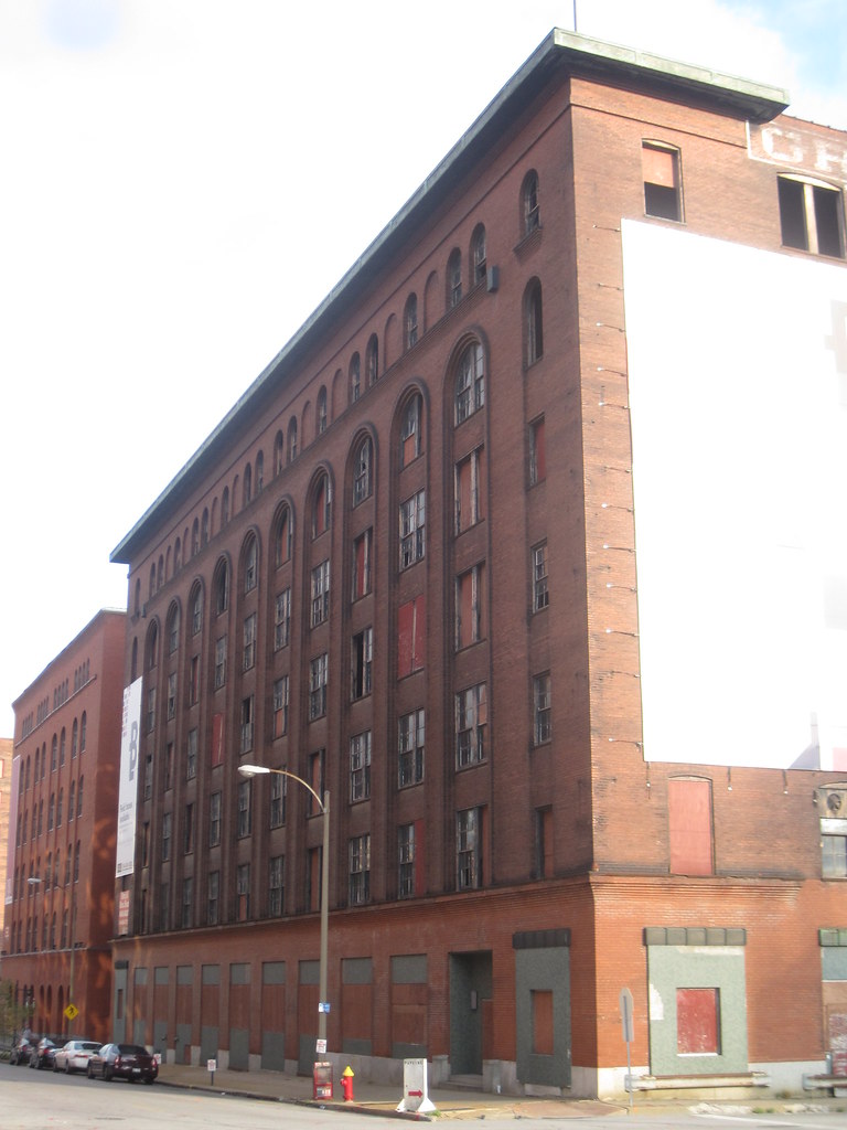
Cupples Station Building 7 before the barriers went up.
This week started with the city’s Building Division moving ahead to surround Cupples Station Building 7 at 11th and Spruce with barriers to protect the public from potential collapses. Spruce Street between 10th and 11th streets is partially closed. This jarring reminder of the old warehouse’s rough condition was followed by owner Kevin McGowan’s statements that he will not preserve a building that he has owned — and let deteriorate — since 2004. The building’s condition is not yet dire enough to demand a death sentence, of course.
Spruce Street closed. View east from 11th Street. Cupples Station Building 7 is at right.
McGowan can pursue an emergency demolition permit if he wishes, or he can apply for a standard demolition permit. Either way, according to Mayor Francis Slay, the permit will go to the city’s Cultural Resources Office and likely to a public hearing at the Preservation Board. Preservationists are wondering if this will be a battle similar to that waged on behalf of the Century Building, of if McGowan will be led to the light of second chance emanating from a certain flying saucer. Either way, the fate of Cupples Station Building 7 will be a serious civic question, and the Mayor’s investment in the question is coming early.
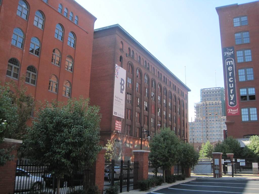
Cupples Station Building 7 at right.
What is at stake is not simply a fine warehouse with gloriously sculptural masonry details, designed by the esteemed local firm of Eames & Young and completed in 1907. The quality of the remaining built environment of Cupples Station, diminished now to nine buildings, lies in the balance. So does the pedestrian quality of downtown south of Walnut Street. This area has long been isolated from the humane scale of north downtown, due to the Gateway Mall and the presence of several hostile 1980s skyscrapers on Market and Chestnut streets. Both the new Busch Stadium and Citygarden have softened the transition from parts of downtown that are pleasant to walk and this neglected zone, and rehabilitation projects at Cupples have populated the area with office workers and a few restaurants and bars. Now is not the moment to reverse that momentum.
View southwest toward Cupples Building 7. The Robert A. Young Federal Building, currently undergoing major rehabilitation, is in the background.
Furthermore, the block of Spruce on which Cupples 7 sits is the last place where there are Cupples warehouses present on both sides of the street. Until very recently, when another Cupples warehouse was foolishly lost in 2004, both faces of the block had two majestic red-brick buildings apiece. Even without one, the set is impressive, as is the visual line of brick on the south side leading to Busch Stadium’s Cupples homage.
Detail on north elevation of Cupples Station Building 7.
On the western end of the block, Building 7 and its earlier neighbor across the street, built in 1900, anchor the corners. Here the genius of Eames & Young’s plan is evident in the convergence of scale, height and materiality contrasted ever-gently with variations in window proportions, cornice profiles and bay divisions. These buildings make a fine set in which no one of them is identical to any other. That variety is irreplaceable, and currently the backbone of any hope there is to build out south downtown with more architecture of this quality. Cupples Station Building 7 must be saved.
View east down Spruce Street toward Busch Stadium. Cupples Station Building 7 is at right.
I shot this short video from the roof of the parking garage south of Cupples Station Building 7. While the view doesn’t show the extent of damage, it provides a sense of the interior condition. All of this could have been prevented by temporary roofing.
From Kara Bowlin, Press Secretary, Office of the Mayor
Starting Tuesday, access to the area around 11th and Spruce Downtown will be limited because portions of the historic Cupples 7 building have become structurally unsound. The City will restrict access to the building to make sure no one gets hurt.
City engineers have determined that the building is unstable enough that the City will close 11th Street from Spruce to Poplar and half a block of Spruce east of 11th Street on Tuesday after the morning rush.
Cupples 7 was built in 1907. The City routinely inspects it and has repeatedly cited the owner because of its deteriorating condition. Severe damage to the building’s roof has exposed the interior of the building to the elements. But, representatives from Ballpark Lofts III LLC, the building’s owner, say it does not have enough money to make the needed repairs to shore up the building. So far, no one has stepped forward with enough money and a plan to protect the structure.
“Building inspectors regularly inspect the building,†said Building Commissioner Frank Oswald. “It’s our job to protect our City’s residents and visitors from unsafe buildings. Unfortunately, we no longer feel confident in this building’s structural integrity. To the untrained eye, the building seems stable at the street level – but years of a severely damaged roof have taken a toll on its stability.â€
Cupples 7 is one of nine Cupples buildings. It is one of only two Cupples buildings that has not yet been renovated – and is the only Cupples building without a renovation plan in place.
Any proposed repair or demolition of this building, a designated City Landmark and in a National Register Historic District, will be subject to review by the Cultural Resources Office.
The Preservation Board approved demolition of the buildings at 921 and 923 Locust Street in 2008.
In October 2008, the Preservation Board unanimously voted to grant preliminary approval to the Roberts Companies’ plan to demolish the two small historic buildings at 921 and 923 Locust Street. At the time, the Roberts Companies had an arrangement with Hotel Indigo to open a new hotel in the historic former warehouse at 917 Locust, and wanted to build a covered entrance, lobby and restaurant addition on the site of the two buildings to the west. This plan was changed after the first rendering appeared to make what appeared to be a two-story building that fully concealed the driveway.
The Hotel Indigo plan had lots of support, but Landmarks Association of St. Louis and architect and advocate Paul Hohmann presciently opposed the demolition plans. Now, nearly three years later, the buildings sport for-sale signs, Hotel Indigo has pulled out of St. Louis and possibilities have emerged. Sometimes, the sky does not fall when a demolition is approved. Sometimes, the sky does not have bank financing and shovel-ready plans.
The building at 921 Locust Street dates to 1916.
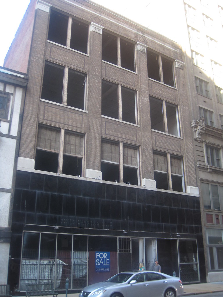
The Roberts Companies are offering all three of the buildings that were to compose the Hotel Indigo. The center building is a handsome three-story brick building with generous fenestration typical of early 20th century Commercial style design. This building dates to 1916, when Martin Monti took out a permit for the building with Nat Abrahams, a prolific minor designer, as architect. The building housed sundry tenants over the years including the Leppert Roos Fur Company and Leacock Sporting Goods Company. This is a bit player in a scene starring lavish terra cotta and penthouse corner offices, but a fine building ready for reuse. Even the absence of windows — oddly removed a few years ago — has not led to any damage.
The corner building at 923 Locust Street has been mythologized. What lies beneath?
The little timbered folly at 923 Locust Street on the corner gets the most attention of any small downtown building. The Tudor-inspired cladding corresponds to a 1947 building permit taken out by Fischer Optical Company, which must have had the clear vision of a slipcover that would delight and intrigue passers-by into the 21st century. This cover has led to years of speculation as to the date of the building underneath, and rumors of antebellum origin. The scale of the building suggests an old age, but the record is not suggestive. The Badaracco family, later to spawn the last citywide Republican officeholder in aldermanic president Joseph Badaracco, took out a permit to building this building on August 14, 1897. (We have a historic photograph of the building which we will post in a later article.)
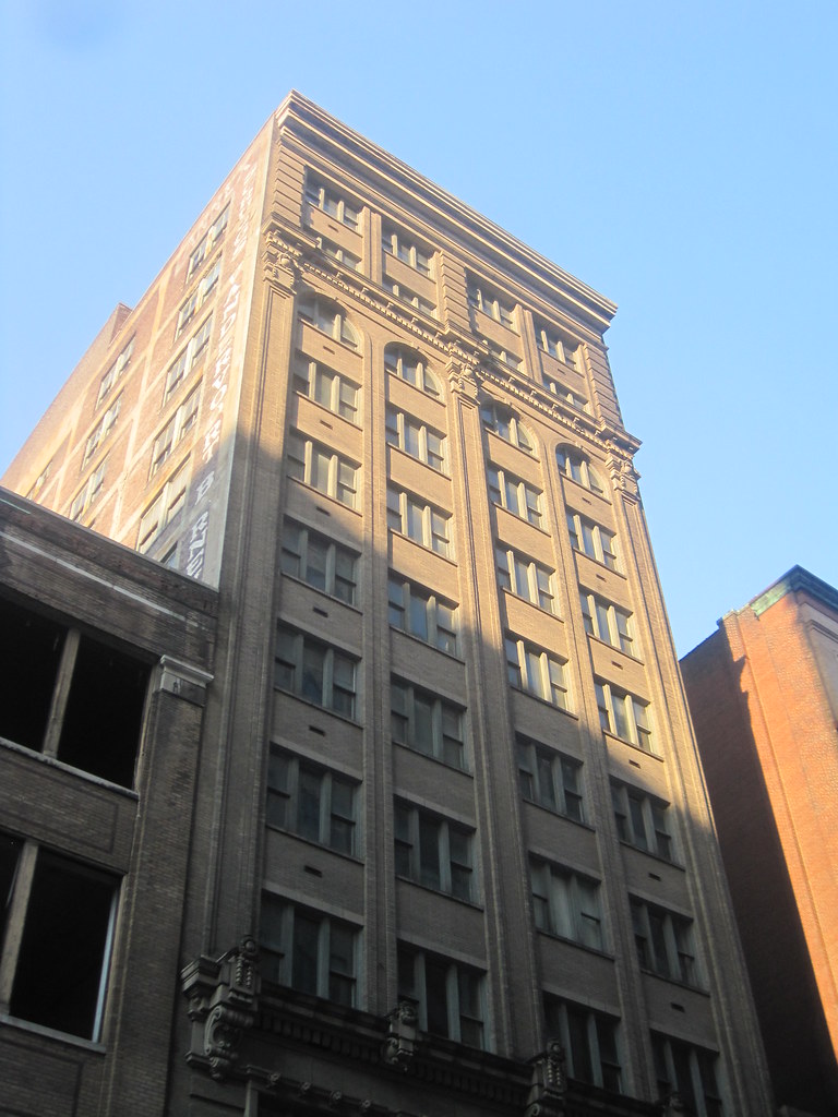
The building at 917 Locust Street was once a warehouse for the Scruggs, Vandervoort & Barney department store.
The twelve-story building at 917 Locust Street is now completely vacant, but from 1989 until 2008 was the St. Louis Design Center. The Design Center attempted to lure design-related tenants into one building with shared spaces. (Two asides: Paul J. McKee, Jr. was one of its developers, and Landmarks Association had its office there for many years.) This slender but richly-detailed building was built as a warehouse for Scruggs, Vandervoort and Barney department store in 1913. In the building’s design, architect Harry F. Roach mirrored the bay divisions, fenestration and even specific ornamental details from his massive Syndicate Trust Building across the street (1907). Scruggs, Vandervoort & Barney was located in the Syndicate Trust and Century buildings, so the clear reference made sense — as did the sealed-but-still-extant underground tunnel connecting the department store to the reinforced concrete warehouse annex. Scruggs used the building as late as 1950, and remained in business across the street until closing in 1967.
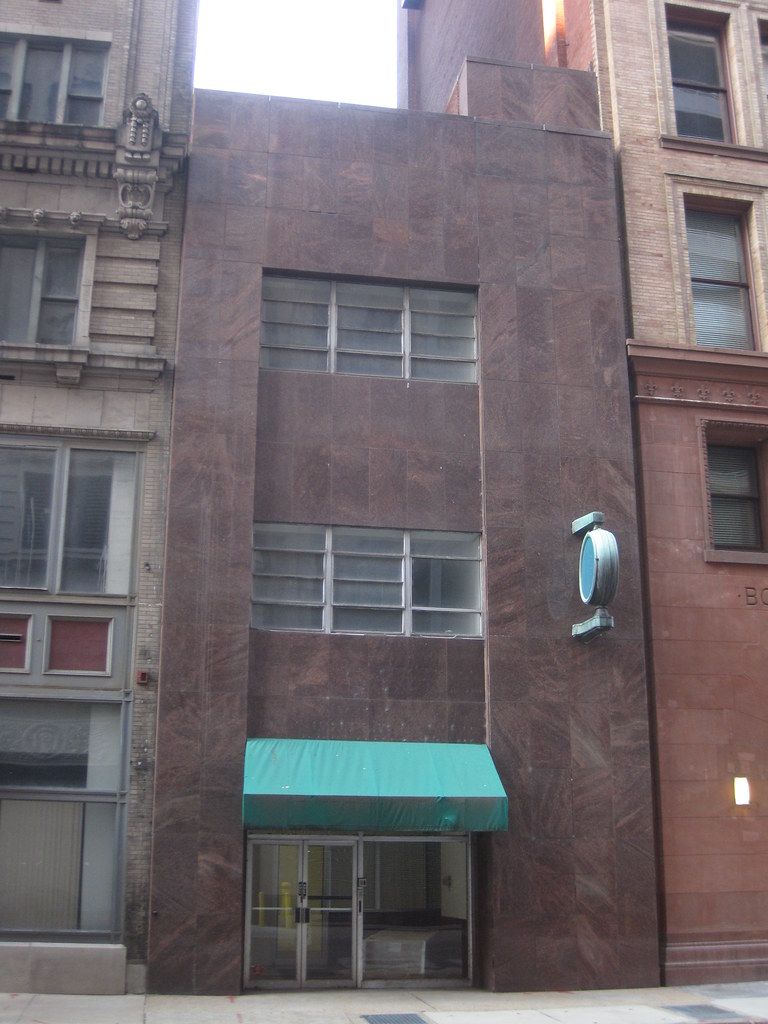
View west down Locust Street toward the 900 block.
One of the great things about the north face of the 900 block of Locust Street is that it presents a continuous row of historic buildings. Isaac Taylor’s massive Renaissance-meets-Romanesque Board of Education Building (1891) anchors the corner, and a slender old building clad in polished granite in 1946 — a simple mid-century slipcover par excellence — stands between it as the old Scruggs warehouse.
The building at 913 Locust Street.
Until 2004, the other side of the street also presented a continuous face of historic architecture in the conjoined Century and Syndicate Trust buildings, but we need not dwell on why that is no longer the case. To the west, despite the 1971 cladding that conceals Mauran, Russell & Garden’s 1920 Merchandise Mart Annex at 1015 Locust, both sides of the street are continuous rows of historic buildings. Hence, Locust Street between Ninth and Eleventh is quite a unique vestige of old downtown, and the group of buildings that includes the three now for-sale is essential to retaining a sense of place eroded in much of our downtown.
View southwest from Second Street at Lucas Avenue on "historic" Laclede's Landing. There's a National Historic Landmark in this photo -- can you spot it?


 From Kara Bowlin, Press Secretary, Office of the Mayor