The business district on South Grand Boulevard between Arsenal Street and Gravois Road showcases the great range of twentieth century architectural styles, forms and materials employed in St. Louis. From the vintage Standard station at Grand and Connecticut, through blocks of two-part commercial structures and up to the tower of St. Pius V Roman Catholic Church, South Grand has a splendidly polyphonous architectural character. Yet there are few mid-century modern buildings in the mix, showing how little demolition visited the district after its early build-out.
South Grand’s mid-century modern landmark remains the diminutive bank building at 3150 S. Grand, right at Juniata Street on the east side. The stark minimalism of this building, built by the Hamiltonian Federal Savings and Loan Association in 1961, contrast with the classicism prevalent in the terra cotta that adorns buildings across the street, and with the contemporary design of the Commerce Bank to the north.
Out of sight, out of mind? Not brick theft. Brick thieves continue to strike abandoned buildings in north city, although the territory of operation has shifted westward. Two years ago, brick theft was prevalent in JeffVanderLou and St. Louis Place. With many targets hit, and fewer vacant buildings left, those neighborhoods have seen a drop in activity. Today brick thieves are more likely to be working in The Ville, Greater Ville, Fountain Park, Fairgrounds and Lewis Place neighborhoods.
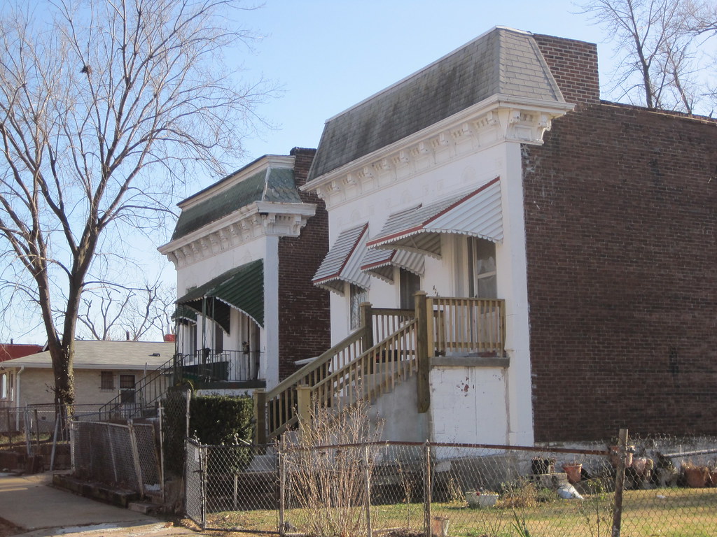
The house at 4477 Page Boulevard.
The thieves are even taking down buildings located on major thoroughfares in north St. Louis. Today I noticed two buildings damaged by obvious illegal demolition activity whose locations are very prominent. The first of these was at 4477 Page Boulevard, just east of Taylor Avenue in Lewis Place. This vacant building may have been marred by fake stone veneer and heavy paint, but its solid structure was intact until very recently. The house stands not far from the campus of Ranken Technical College, and on a block where most buildings are occupied.
On January 17, the National Park Service listed in the National Register of Historic Places three historic districts in and an amended and expanded historic context for The Ville neighborhood. Due to lack of contiguous historic fabric, The Ville is not eligible for listing as single historic district. All National Register listings are made using the requirements of Historic and Architectural Resources of the Ville Multiple Property Submission (MPS), first created in 1999.
The Herman Dreer House (built 1930) at 4335 Cote Brilliante Avenue is at left; it was listed in the National Register in 2009. Now the rest of its block is within the National Register-listed Marshall School Neighborhood in The Ville Historic District.
Until last month, The Ville MPS lacked a section that would enable listing of groups of residential and commercial buildings associated with general trends of African-American settlement between 1910 and 1950. Buildings had to be associated with significant institutions or individuals. Most building stock in The Ville is the backdrop for significant twentieth century history — a context that preserves the character of an entire era of significant cultural activity. Listing intact groups of buildings helps preserve the sense of place enjoyed by Annie Malone, Herman Dreer, Charles Henry Turner, Julia Davis and other prominent African-Americans who either lived or worked in the neighborhood in its heyday.
The city’s Cultural Resources Office (CRO) staff rewrote the Historic and Architectural Resources of the Ville MPS document, adding a well-written and must-read section (“Context III: The Ville as the Product of Residential Segregation Policies, 1910-1950”) that documents the larger settlement history as well as “registration requirements” for the building stock long not covered by the document. The Preservation Research Office submitted the three small historic districts that are the first to be nominated under the new section.
The three districts are not the only small residential districts eligible in The Ville, but are the only ones identified as eligible in The Heart of the Ville architectural survey conducted in 2009 and 2010. Additional surveys should be funded to identify other potential districts in The Ville. Meantime, there now are 90 more buildings eligible for historic tax credits in The Ville!
Creating National Register of Historic Places historic district designations often is straightforward work — a consultant delineates the boundary of an eligible area dense with urban building stock. Then there are depleted neighborhoods in north St. Louis, where the levels of demolition make defensible boundaries more difficult. With extensive demolition marring its streetscapes, The Ville is no exception. Yet The Ville has a historic importance as the cultural center of African-American life in St. Louis rivaled only by the lost Mill Creek Valley.
Since 1987, The Ville has been a Local Historic District with restrictions on demolition, but until recently little of it had National Register of Historic Places status. Beyond the great cultural honor, that status makes available federal and state rehabilitation tax credits — the programs that revived Dick Gregory Place in the western end of the neighborhood. Since taking office in 2007, Alderman Sam Moore (D-4th) has pushed to find solutions for historic preservation of The Ville’s buildings, many of which face the wrecking ball in the absence of incentives for their reuse. One of the city’s most important neighborhoods seemed to be disappearing over the last few decades, but finally there may be a change in direction.
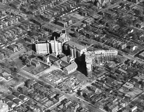
This historic view shows Homer G. Phillips Hospital under construction in 1936. Areas to the south and west of the hospital were included in the recent "Heart of the Ville" architectural survey.
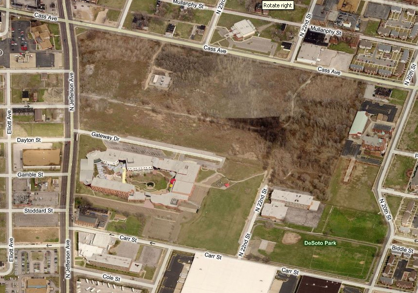
Between August 2009 and August 2010, under contract to city government, the Preservation Research Office (PRO) completed the first intensive architectural survey of the heart of St. Louis’ fragile yet historically significant African-American neighborhood The Ville. The “Heart of the Ville” survey was the result of the successful St. Louis Cultural Resources Office (CRO) application for a Historic Preservation Grant to survey the Ville neighborhood, a local historic district with outstanding significance and uneven integrity. PRO evaluated 368 primary resources and 49 secondary resources, all buildings, to form the basis for historic district nominations. As of this writing, three small Ville historic districts are now listed in the National Register of Historic Places based on the survey results. (See subsequent post.)
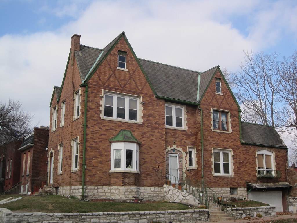
The Tudor Revival home and residence of African-American physician Dr. Leo Commissiong stands at 4201 Aldine Avenue. Built in 1931 and designed and built by F.L. Whittaker, this house could be individually eligible if more research on Dr. Commissiong established him as a significant individual.The houses at 4242 and 4246 W. Garfield Avenue are among several raised-basement Italianate-style homes in the survey area. These residences were built circa 1890.
The survey was designed as a cooperative effort between the City of St. Louis CRO and Lynn Josse and Michael Allen at PRO. In November, 2009, PRO signed a contract with the city to provide a reconnaissance survey of 300 properties within the boundaries of the Ville neighborhood. Because this number would include fewer than half of the potentially historic residential and commercial properties within the originally identified survey area, CRO and the contractors targeted a much smaller set of blocks within the Ville. The new boundaries were selected based on the level of threat to the targeted resources.
A base map used by the consultants in the survey report. The cyan lines indicate the districts ultimately created from the survey results.
This survey differed from many others because the neighborhood has already been the subject of intensive study over three decades. In 1983-84, Landmarks Association of St. Louis conducted a reconnaissance survey of the Ville. In 1987, the City of St. Louis designated most of the Ville neighborhood as a local historic district. Two years later, the National Park Service (NPS) rejected certification of the Ville Local Historic District — a process that allowed other neighborhoods to have both local and national designation — due to extensive building loss in parts of the district. Consequently, the Historic and Architectural Resources of the Ville Multiple Property Submission was developed by Landmarks Association of St. Louis and approved by the National Park Service in 1999. The MPS offers three contexts under which individual buildings or groups could be listed in the National Register. The contexts are: “Black Settlement in the Ville, 1865-1910” and “The Ville as a Center for African-American Culture, 1910-1950”. The MPS establishes registration requirements for Institutional Buildings but no other types, stating that this is “the first phase of what is hoped to be a long-term project of evaluating and registering properties in the Ville.”
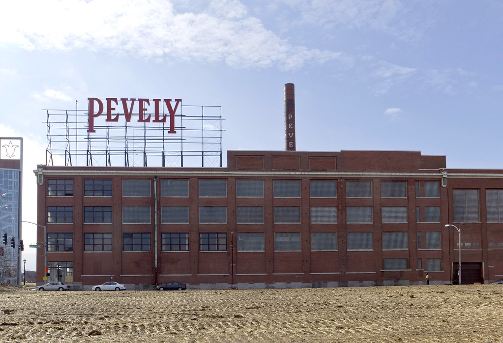
To start: no matter what the result of last night’s Planning Commission meeting, public input counts. If any historic building under threat of demolition is to have a fighting chance in this city, your emails, testimony, and public demonstrations are essential. Tonight, in the case of the Pevely complex, when the long-standing ordinance forbidding its demolition was hardly addressed and when new public testimony was not allowed, prior community support for its preservation was noted numerous times. This support ultimately failed to tip the scales in favor of Pevely, but it was certainly better than having the record state that “there were no emails, there was no one who cared enough to stand up for these buildings.”
Pevely Dairy Plant photograph by Michaela Burwell-Taylor.
That said, the meeting resulted in the overturning of every facet of the Preservation Board’s December 20th decision to deny demolition of the Pevely corner building and smokestack, and of its prior decision to grant demolitions of the milk plant and garage on the condition that St. Louis University apply for a building permit for its new facility first. Instead, the Planning Commission voted almost unanimously to allow the demolition of all four structures. The small measure of “compromise” struck was that the corner office building cannot be demolished until the university applies for a building permit. Only one commissioner, Patrick R. Brown from the office of Mayor Francis Slay, voted against the motions.
The two-hour long meeting was convened at SLU’s behest, for under the city’s preservation ordinance property owners denied demolition permits may appeal that decision to the Planning Commission, which ostensibly judges the “correctness” of the other body’s ruling under city law. Only Cultural Resources Office Director Besty Bradley was permitted to testify in support of the Pevely buildings, while SLU’s attorney, school president Father Lawrence Biondi, and architect Steve Smith of the Lawrence Group argued in favor of demolition. SLU’s representatives repeated many of their earlier arguments from the Preservation Board meeting.
Pevely Dairy Plant photograph by Michaela Burwell-Taylor.
Hyperbolic statements ruled the evening: if SLU doesn’t build this building on this site, it will lose competitiveness, doctors will flee, the university will close its medical school and move to the suburbs. Barnes, its only urban counterpart, has no green space, but SLU needs green space surrounding its new building for walkability and patient use, despite the fact that SLU’s current lawn around the Doisy Center across the street is wholly barren and that similar open green space fronting Grand would be undesirable for medical patients undergoing treatment. The corner Pevely building, currently slated for that green space, would cost too much too rehabilitate, although such rehabilitation would be a mere fraction of the $80 million SLU has for new facilities on the site. When asked by the commission why it rebuffed conditions mandating that it present concrete building plans prior to receiving demolition permits — a seemingly reasonable compromise — SLU’s attorney responded that it was a “psychological issue,” that the university felt it deserved the flexibility. Despite earlier statements to the contrary, SLU now says that the historic smokestack is a hazard, making it clear that it never intended to retain it.
Only fleeting mention was made of the massive lot directly north of the Pevely site on northwest corner of Grand and Chouteau, owned and recently cleared by SLU, a site which would be ideal for the new ambulatory care facility but for which the university has not released plans. None of the discussion focused on whether the Preservation Board had correctly upheld the city’s preservation ordinance, which clearly states that sound National Register-listed buildings such as those in the Pevely complex should not be demolished.
In the end, community members who sought to preserve the Pevely did what they could within the system that we have. Renderings showing how the building could be reused, generated during the design charrette co-sponsored by the Preservation Research Office and the Landmarks Association, were given to the Planning Commission prior to the meeting, as were all emails sent to the Cultural Resources Office and the transcript of public testimony recorded at the Preservation Board meeting. Convincing the Preservation Board was something of a first. We can only build on that experience for the future.
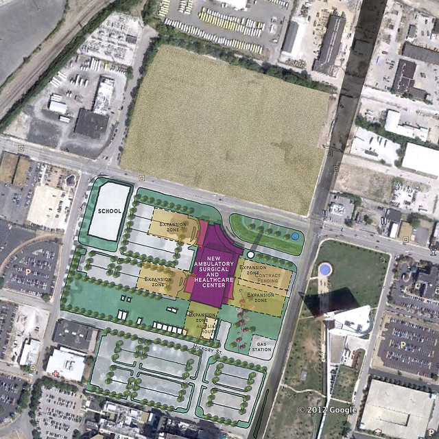
Across Chouteau Avenue from the Pevely Dairy Plant, St. Louis University has cleared several older industrial buildings. In recent days, the straw-strewn vacant lot has been awash with birds picking out the grass seeds. This prominent location, elevated above Grand Avenue to the east, now will sit idle for the time being. St. Louis University, a non-profit corporation, will not pay real estate taxes on this valuable central corridor site. Until developed, the site is producing absolutely nothing in economic good for the city.
Jeremy Claggett posted an article at nextSTL that shows how the university’s proposed ambulatory care center could occupy this newly-cleared land mass. Construction could start immediately, and the value of the Pevely Dairy Plant would increase with the investment across the street.
In the early twentieth century, urban planning became a function of city government in order to curb rampant private misuse. At its best, municipal planning ensures thoughtful lands stewardship remains an enforceable public good. This happens through a priori guidance — comprehensive planning. Commissions’ denying demolition permits serves as a negative force that can prevent careless losses of historic buildings with cultural and economic value, but such denials do not constitute effective urban planning.
St. Louis University’s land acquisitions around the medical center demonstrate that in the absence of strong municipal planning, the university has created its own comprehensive plan. That plan may lead to job creation and provision of some public goods, like ambulatory care, but it remains a plan to achieve private institutional goals. The university’s wishes for future development of the corner of Grand and Chouteau may coincide with the public good, but they are not responsive to it.
At present, the public good is manifest through citizen power brought to public meetings at the Preservation Board, Board of Aldermen and other venues. Citizens have asserted that the public good is not served by allowing demolition of the Pevely Dairy when the university has enough land to build ten ambulatory care centers and still leave the historic dairy plant standing. All people are saying is that the university’s planning should be subsumed to the interests of the entire city.
The interests of the city are not served by the university’s land-banking, nor by the university’s wanton demolition of buildings listed in the National Register of Historic Places (a not-easy-to-obtain federal designation created in 1966 that represents the public interest). The absurdity of taking down the Pevely Plant when there is a giant, fresh moonscape across the street is clear to the public, the majority of Preservation Board members and seemingly to Mayor Francis Slay. That’s a glaring point of contest, though. The larger issue remains more diffuse: St. Louis University’s planning for the medical center area is happening without the presence of assertive municipal comprehensive planning. The Pevely Dairy demolition won’t be the last battle here.
The St. Louis Development Corporation has proposed initiating a $100,000 two-year option on the 33-acre Pruitt-Igoe site for Paul J. McKee, Jr.’s Northside Regeneration LLC. During that time, the ddeveloper would have exclusive right to purchase the site for $900,000. What does this mean for the future of the site of one of the city’s most important events from the recent past?
For now, it means that the developer will be able to lay claim to the ground, and market the site as the potential location for commercial buildings. Yet the option does not stop public imagination of what could be done with the site. The Pruitt-Igoe parcel is owned by the Land Clearance for Redevelopment Authority, a public agency. Thus we are all owners of the site, and its future is a question of public interest. Most sites in the Northside Regeneration footprint are of marginal historic interest, but this one is rich with symbolism. What happens to Pruitt-Igoe’s remaining vacant land reflects our collective regard for the lives of all who lived in the housing project there.
Ahead of Northside Regeneration’s option, last summer I joined my collaborator Nora Wendl in launching the independent ideas competition Pruitt Igoe Now. Pruitt Igoe Now has solicited ideas and designs for the site’s reuse, and has attracted the interest of participants from around the world. We close the competition on March 16, and announce winners in late May. Our purpose is not to block redevelopment but to offer a powerful moment of civic reflection.
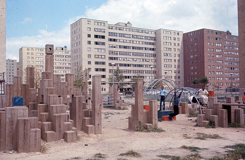
A playground at Pruitt-Igoe. Photograph courtesy of the State Historical Society of Missouri.
How do we honor the past life of the Pruitt-Igoe site through its renewal? Often historic sites connected with significant African-American experience are lost without deliberation. The list of buildings lost in Mill Creek Valley, JeffVanderLou and The Ville is staggering. The loss of public housing buildings has erased much of the postwar history of struggle and accomplishment. Pruitt-Igoe’s ruins are left as an imperfect marker of a complicated but definitive chapter in the city’s history.
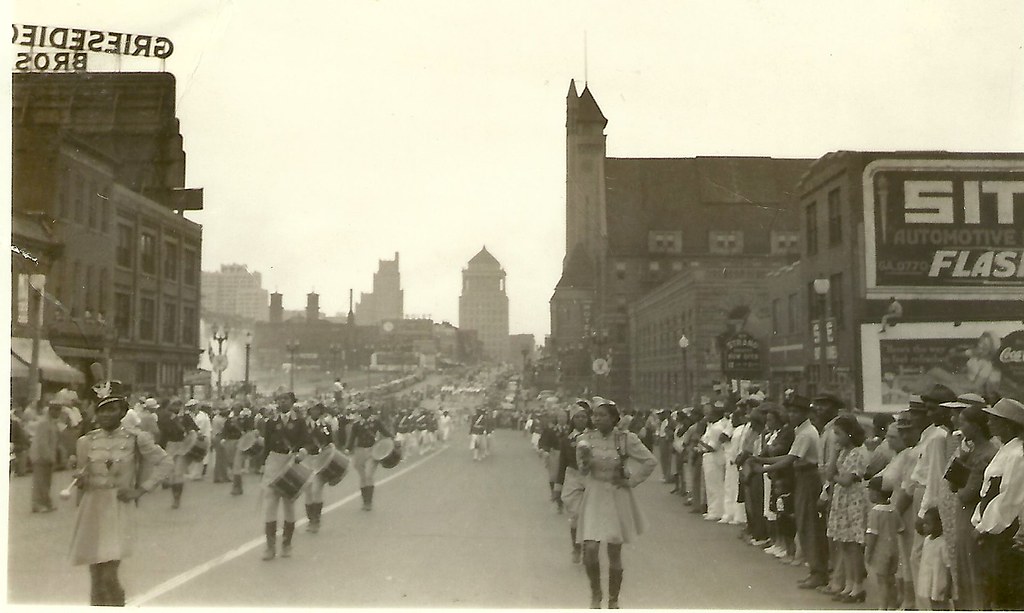
Another photograph from our collection of amateur images of the St. Louis built environment captures a parade moving westward down Market Street into Mill Creek Valley. The view was taken west of 21st street, and shows a panorama of the mid-century downtown skyline. Lacking a date, the image nonetheless offers a major clue: the surging waters of fountains around Carl Milles’ The Marriage of the Waters in Aloe Plaza can be seen at left. That installation was completed in 1940.
The image was taken before 1954, because the photograph shows blocks of vernacular, small-scale buildings between 18th and 15th streets that would be leveled for park space. Eventually this landscape would become the Gateway Mall. The buildings in the foreground would be leveled after 1959 as part of Mill Creek Valley clearance. Later, this area would be rebuilt with depressed on-ramps as part of the stalled North-South Distributor project.
Somewhere between the triumph of early intervention and later, more troubling urban renewal, a parade passed through this scene. The moment captured shows the African-American community of Mill Creek Valley in celebration, right in the heart of the city. By 1965, this community would be forever removed, and its built environment replaced by an uninspired landscape. Today city leaders have embraced the Northside Regeneration project, which calls for reconstructing the urban street grid west of Union Station and building dense infill there. Yet this photograph reminds us that architectural character is only the backdrop for urban cultural experience. Mill Creek Valley’s lively culture will never return to Market Street, and for that this city is worse.
Anyone who is on the listserve of the St. Louis Rehabbers Club knows that Dave Lewis’ insights and tips on rehab work are indispensable. Those who have lived in Soulard in the last few decades no doubt know Dave’s work rehabbing his two buildings, his beautiful garden project or his assistance with countless projects of his neighbors. This video’s title suggests that Dave Lewis is the “Soul of Soulard,” a mantle (ouch) he would probably decline out of modesty. No matter; Dave’s life’s work speaks for itself.