Categories
Midtown Mill Creek Valley

“The Million Dollar Dance Palace”: Vice and Virtue at the Castle Ballroom

by Lynn Josse

The Castle Ballroom stands at the northeast corner of Olive and T.E. Huntley streets.

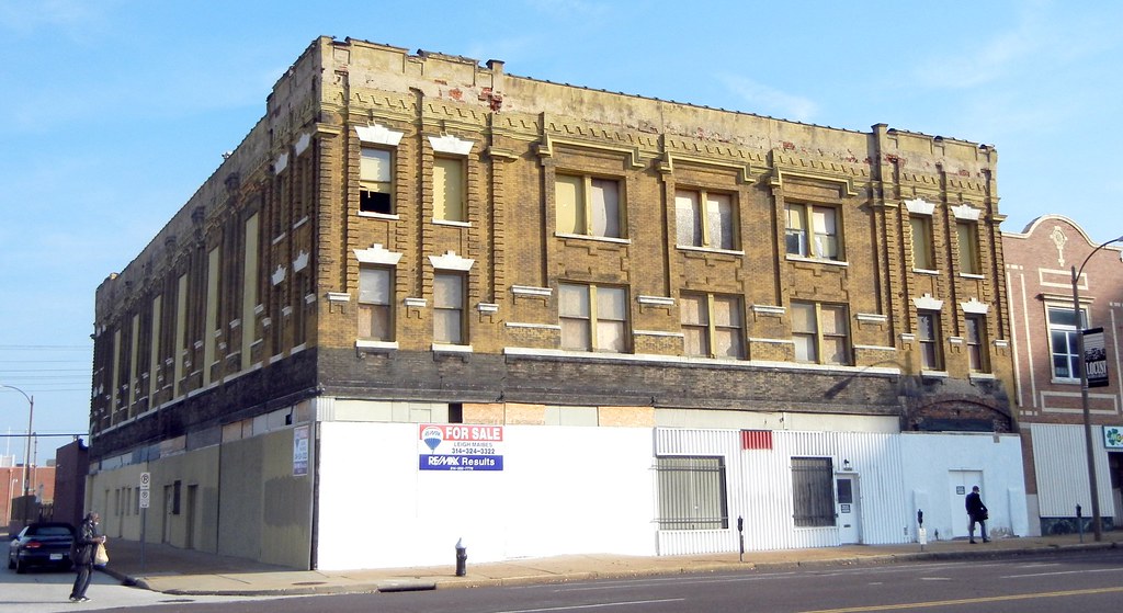
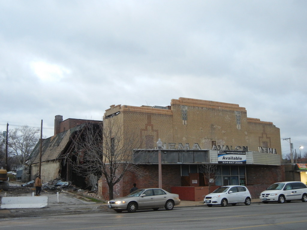
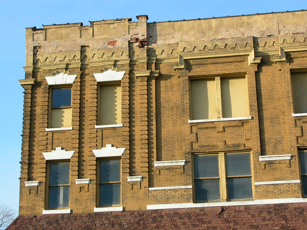
A lot of what you need to know about the Castle Ballroom can be read on its exterior. The commercial first floor of the building indicates its historic place on a busy streetcar line. Graceful double-height arched windows above the first story reveal a ballroom which extends almost from the street to the alley. The lively Renaissance Revival brickwork indicates the aspirations of the owners in 1908 — this is a proper dance academy, not a warehouse. Perhaps the most telling piece of evidence isn’t part of the building itself, but in the enormous expanse of lawn across the street. The Castle Ballroom had epitomized early 20th century elegance, but half a century later it was only spared from the nation’s largest urban renewal slum clearance project by virtue of being on the north side of Olive rather than the south side. Put all of these pieces together, and you’ve got the story.

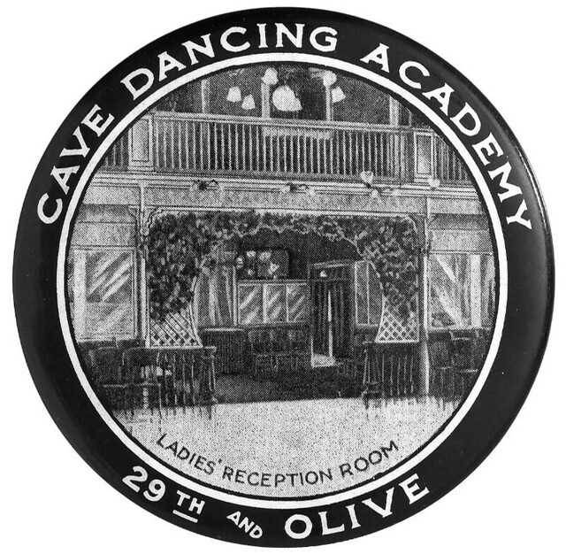
In just over four decades of operation, the Castle Ballroom witnessed and responded to wave after wave of changing taste in music and dance. Herman Albers and Cornelius Ahern constructed the building in 1908. Architect J.D. Paulus designed the building. They had previously operated the dance academy at Cave Hall, the above-ground entertainment center associated with Uhrig’s Cave at the southwest corner of Jefferson and Washington. When the old Cave Hall was demolished to make way for the Coliseum, they took the name with them.

Derivative of cave Dancing Academy postcard, c. 1910.

Mr. and Mrs. Albers and Mr. and Mrs. Ahern themselves supervised the dancing at the new hall, and the Uhrig’s Cave Orchestra followed them to the new location. By this time, traditional tastes in music were giving way to a new sensation — ragtime. The syncopated rhythms of the ragtime music invited a daringly different style of dancing. Scandalous new “animal dances” (the Turkey Trot, Bunny Hug, and Grizzly Bear, among others) were popularized at the highest levels of society. In 1911, Chief of Police William Young instituted a Morality Squad to inspect public dance halls and stop the vulgar new dances wherever they occurred. Newspapers gleefully covered the controversy, their condemnations illustrated with titillating line drawings of couples in unseemly poses. Alexander DeMenil, always a spokesman for Victorian values in the Edwardian age, wrote that the dances were a symptom of society’s decadence. “We do today openly and publicly what we would have been ashamed to do in secret ten years ago,” he wrote in 1913. “Far from being ‘new,’ these dances are a revision of the grossest practices of savage men.”

Souvenir image from the Cave Dancing Academy.
Interviewed in 1929, Herman Albers indicated that Cave Hall had always remained a place of the utmost propriety. There is no evidence to contradict him. The owners never offered comment in the press wars over the new dances. Their Central West End colleagues Jacob Mahler and Alice Martin, both still remembered in St. Louis dance history, were the most frequently quoted. When the Post-Dispatch accompanied the Morality Squad officers on a night’s rounds near the end of 1911, they made it all the way to Cave Hall only to remember it was closed on Mondays. (The article, dated December 12, 1911, boasts one of the most memorable headlines of all time: “Morality Squad, Seeking Revelry, Fails to Find It.”)

If the moralists thought the ragtime dances were bad, what came next was much, much worse. Jazz music invited even more jumping and gyration. Instructors of traditional ballroom dance banded together in self-defense, encouraging additional legislation to eradicate dances such as the “Camel Walk.” The new ordinance was designed to “reach the irresponsible dancing teachers who, because of the money there is in it, will teach any kind of wiggle.”

After his partner’s death, Albers changed the name of the venue to Castle Ballroom. In doing so, he embraced a more modern image for the academy. Vernon and Irene Castle had been the greatest names in dancing until Vernon’s death in a training accident during World War I. The Castles earned their success by taking modern dances and making them completely respectable. Today, the name “Castle” may sound like a reference to the building, but in 1922 the allusion to the famous dancers could not have been missed.

The dawn of the Jazz Age spelled the end of the great ballroom dancing academies of St. Louis. As early as 1922, dance instructor Alice Martin claimed to have “practically given up teaching ballroom dancing” because of the “vulgar extremes of these times….” By 1930, most teachers of ballroom dancing had stopped advertising. The Castle’s newspaper advertisements increasingly emphasized the hall’s availability for rental.

Impressive corbelling on the Olive Street elevation of the Castle Ballroom.

In 1934, Herman Albers closed the Castle and filed for personal bankruptcy. The end of Prohibition had played a role, his attorney noted, since people now danced at cafes where liquor was sold. He also blamed the widening of Olive Street and a change in streetcar stops. His comments to the Globe-Democrat overlook an obvious demographic shift in the neighborhood.

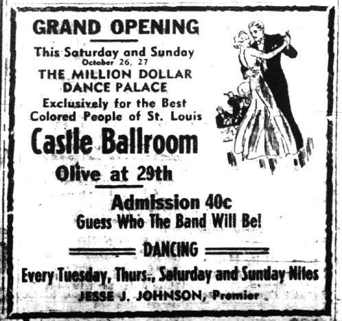
In the second and third decades of the 20th century, the immediate neighborhood of the Castle Ballroom, especially the blocks just south, had transitioned from an almost completely Caucasian neighborhood to one that was dominated by African American institutions. The fabled Mill Creek Valley neighborhood developed the city’s greatest concentration and number of black residents. When the Castle re-opened in 1935, it was advertised as “THE MILLION DOLLAR DANCE PALACE – Exclusively for the Best Colored People of St. Louis.” The hall again held dances on Tuesday, Thursday, Saturday and Sunday nights, but they were advertised to a different clientele.

Advertisement that appeared in the St. Louis Argus on October 25, 1935.

Manager Jesse Johnson was frequently touted in The St. Louis Argus as the city’s top black promoter. A favorite house band was Eddie Randle’s St. Louis Blue Devils. According to one account, it was at the Castle Ballroom that the teenaged Miles Davis first auditioned for the band. With Eddie Randle (playing regularly at the Castle as well as other venues around town), the young prodigy received his first experience playing in a professional band. By the end of the 1930s, Johnson brought in more national acts, including Duke Ellington. Under other management, the entertainment included Fletcher Henderson, Ella Fitzgerald, Fats Domino, and Count Basie. Through the 1940s, the Castle featured local and national touring acts and hosted many private events for black organizations.

The early 1950s brought the Mocambo Club (named for a famous Los Angeles hot spot) This club lasted barely a month before a dispute at the bar turned into a sensational shootout which claimed the life of the owner and a local underworld figure. The Globe-Democrat reported that there were thirty people present but only one witness. When the club reopened under new management, it was still able to attract national favorites such as Louis Armstrong and the Ink Spots, both in 1952.

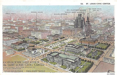
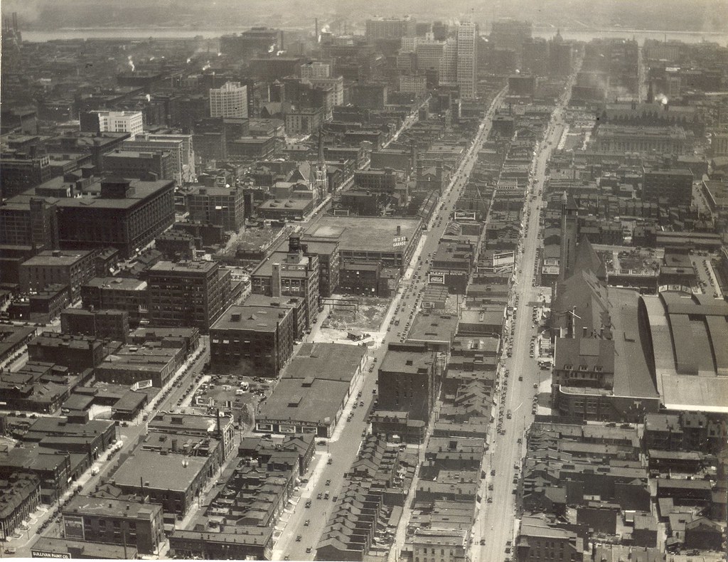
The final days of the Castle Ballroom coincided with a civic effort toward slum clearance. Mill Creek Valley at this time retained the deteriorated housing stock of the 19th century, densely packed with African Americans who were allowed few other living options. The neighborhood had a high crime rate, high infant mortality rate, and low indoor plumbing rate. One planning document described the neighborhood as “100 blocks of hopeless, rat-infested, residential slums.”

A bond issue for clearance and redevelopment failed in 1948. Amendments to federal law in 1954 allowed the Mill Creek Valley to become an urban renewal project, and voters approved matching local funding in 1955. Original plans called for 4,200 families to be relocated from a 107-block area. Roughly 2100 buildings plus accessory structures were to be demolished.

Heritage House under construction in Mill Creek Valley, 1965. Olive Street is at the bottom of the frame, with the Castle Ballroom just outside of the shot to the right. (Globe-Democrat Collection.)

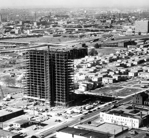
The northern boundary of the clearance area was Olive Street. Beginning in 1959, nearly every home, church, and business in Mill Creek was demolished. Thriving commercial districts, significant institutional buildings (including the Pine Street YMCA) and untold homes were knocked to rubble and sent to the landfill. The vast majority of Mill Creek residents were not resettled in the new housing that was built across from the Castle.

The ballroom as it appears today.

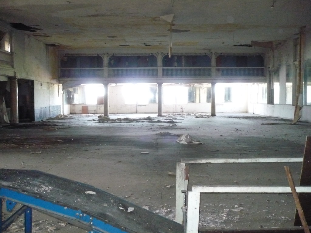
Today, the Castle Ballroom is one of the last buildings in the area to retain a strong association with the African American community that once surrounded it. The second story ballroom has not seen dancing since the 1950s, but now it has another chance. The building is on the market and substantial historic tax credits are available for its restoration. Several potential buyers have come forward, but none have committed yet. (If you’re interested in purchasing the building, visit the realtor’s web site at www.leighmaibes.com.) Public interest is also increasing, with recent appearances on music history tours by Michael Allen and Kevin Belford. Landmarks Association’s hard hat tour this past Saturday sold out, and a second tour is scheduled for February 4 (details here).

Our full nomination of the Castle Ballroom is on the State Historic Preservation Office web site here.

Categories
Demolition Southampton Theaters

Without Review, Avalon Theater Demolition Underway

by Michael R. Allen

One day after my call for an imaginative path away from demolition of the Avalon Theater, wreckers started destroying the south city landmark. This morning, after considering it since December 22, the Building Division approved the demolition permit. Down came theater walls and steel trusses, headed up to North Broadway scrap yards.

If the Avalon had been protected under the city’s preservation ordinance, the demolition permit would have required the additional approval of the city’s Cultural Resources Office. Failure to get that approval would have caused a denial of the application.

Unfortunately, the 14th Ward is not in preservation review, and the Avalon had no local or national landmark status that would have led to review under the preservation ordinance. Yet the Avalon was eligible for National Register of Historic Places listing, on its own or as a contributing resource to larger districts.

Categories
South St. Louis Southampton Theaters

Coming Soon: The Future of the Avalon Theater

by Michael R. Allen

Is the Avalon Theater poised to be revitalized as a two-screen neighborhood cinema, a concert venue or a cafe with three-seasons dining in a re-purposed auditorium? Unless the owners drop a pending application for demolition, the answer is “we will never find out.”

Avalon rendering by Jesiey Mead.

On December 22, owner Greg Tsevis applied for a demolition permit for the shuttered Art Deco movie house. So far, the Building Division has not approved the application (#495332). Yet there is nothing standing in the way of approval — the Avalon lacks any protection from demolition under the city’s preservation ordinance. The Avalon Theater is not a City Landmark, is not listed in the National Register of Historic Places and is not located in one of the 20 city wards that have preservation review. The 14th Ward, where the Avalon is located, is one of only two south side wards without demolition review. (Alderman Stephen Gregali kept the 14th Ward out of preservation review and his successor, Carol Howard, has not placed the ward under review.)

Demolition seems a hasty move given that the Avalon has only been listed on the market since August at $250,000, after having sat for years with an unrealistic asking price of over $900,000. Since the price dropped to a reasonable amount, several parties have tried to assemble rehabilitation plans for the Avalon. Yet all would-be buyers need historic tax credits to make the costs of rehabilitation work, and the building needs to be listed in the National Register of Historic Places first. The process of listing can take up to six months. No one will close on purchase without securing rehabilitation financing.

Categories
Downtown Gateway Mall Parks

The Evolution of the Gateway Mall (Part 6): The Design Competition of 1966-1967

by Michael R. Allen

This is the sixth part of a nine-part series on the evolution of the Gateway Mall, that ribbon of park space that runs between Market and Chestnut streets and from the Jefferson National Expansion memorial westward to Twenty-Second Street downtown. This article began its life as a lecture that I delivered to the Friends of Tower Grove Park on February 3, 2008, and was published in its entirety in the NewsLetter of the Society of Architectural Historians, Missouri Valley chapter in Spring 2011.

In March 1966, an undeterred Mayor Alphonso Cervantes traveled to New York City for the public announcement of a national design competition with a $15,000 prize for a master design for the entire Gateway Mall. The city and Downtown St. Louis, Inc. sponsored the design competition. Fifty-seven firms or individuals submitted designs before the winner was announced in June 1967.

View toward the Old Courthouse from Seventh and Chestnut, in 1968, showing the future site of the Morton D. May Ampitheater. (Preservation Research Office Collection.)

The boundary of the competition was set with the Old Courthouse at the east and the proposed North-South Distributor (roughly Twenty-Second Street) at the west. the competition was the first attempt at a master plan for a landscape that was merely six years old in the minds of planners. By this time, downtown had lost so much building stock and street life that the old rationalist rhetoric about alleviating the ills of the central city would have been ludicrous. Instead, Cervantes and civic leaders began to talk up the effect of the Gateway Mall as an instrument that might lead to building up the core. With the Mall extended, they argued, Chestnut and Market streets would become desirable sites for the sorts of large corporate headquarters St. Louis desperately wanted to attract. The rhetorical emphasis shifted from social to economic benefits, but the rationalist framework remained latent.

One of Sasaki, Dawson & DeMay's dramatic renderings of the Gateway Mall concept published in Architectural Forum.
Categories
Downtown Gateway Mall Mid-Century Modern Parks

The Evolution of the Gateway Mall (Part 5): The 1960 Downtown Plan

by Michael R. Allen

This is the fifth part of a nine-part series on the evolution of the Gateway Mall, that ribbon of park space that runs between Market and Chestnut streets and from the Jefferson National Expansion memorial westward to Twenty-Second Street downtown. This article began its life as a lecture that I delivered to the Friends of Tower Grove Park on February 3, 2008, and was published in its entirety in the NewsLetter of the Society of Architectural Historians, Missouri Valley chapter in Spring 2011.

This aerial rendering of downtown St. Louis shows the relationship between Memorial Plaza (left) and the downtown core in which the Gateway Mall would be built. (Postcard, c. 1940.)

Selection of Eero Saarinen and Dan Kiley’s plan for the Jefferson National Expansion Memorial design in the 1948 design competition drew planners’ attention to eastern downtown. In 1954, the architectural firm Russell, Mullgardt, Schwarz & Van Hoefen published a rendering of an eastern park mall running from the Civil Courts and terminating at the new Memorial. The block between Third (now Memorial Drive) and Fourth Streets would be landscaped by the National Park Service as part of the Memorial and named Luther Ely Smith Square. The firm’s rendering was the first time that the idea of extending the downtown park system to the east had been considered.

The rendering by Russell, Mullgardt, Schwarz & Van Hoefen coincided with creation of the western blocks between Fifteenth and Eighteenth streets between 1954 and 1960. Those blocks joined existing Memorial and Aloe plaza blocks to form a mall-like line of parks from Twelfth Street (later Tucker Boulevard) west to Twentieth streets. The new Jefferson National Expansion Memorial and Luther Ely Smith Square shaped an eastern terminus for the larger park project that would soon be named the Gateway Mall.

The eastern part of the park mall is clearly visible in this 1960 rendering for the downtown plan by Erwin Carl Schmidt.

Yet the Civil Courts Building and the Old Courthouse were obstacles to a continuous park mall. Still, the rendering of formally symmetrical park space joining the existing Memorial Plaza and park mall at the west to the Memorial at the east was immediately popular. Anticipating timely completion of the Jefferson National Expansion Memorial, downtown business leaders wanted to reconstruct eastern downtown with a modern built environment worthy of a major international landscape.

Categories
Downtown Gateway Mall Parks

The Evolution of the Gateway Mall (Part 4): Building the Civic Center, 1919-1960

by Michael R. Allen

This is the fourth part of a nine-part series on the evolution of the Gateway Mall, that ribbon of park space that runs between Market and Chestnut streets and from the Jefferson National Expansion memorial westward to Twenty-Second Street downtown. This article began its life as a lecture that I delivered to the Friends of Tower Grove Park on February 3, 2008, and was published in its entirety in the NewsLetter of the Society of Architectural Historians, Missouri Valley chapter in Spring 2011.

1950s view of the realized civic center, Memorial Plaza, looking northeast with the Soldiers' Memorial at left and the Civil Courts at right. (Preservation Research Office Collection.)

In 1919 the City Plan Commission published A Public Building Group Plan. The plan called for creation of green space on blocks between 12th, Market, 14th and Chestnut streets, with two blocks extending north to the Central Library on Olive between 13th and 14th Streets. The plan called the center spine between the library and the Municipal Courts building “the mall.” All around this park space would be new civic buildings, including a massive auditorium, a court house and others. To the west, a new plaza would be built across from Union Station. The plazas would be further adorned with fountains, an obelisk, and statues for a park environment devoid of nature fully designed as monumental space.

Postcard rendering of the 1919 Public Buildings Group Plan. (Preservation Research Office Collection.)

The title page of A Public Building Group Plan bore the name of the new City Engineer, Harland Bartholomew, whose persistence and commitment to City Beautiful principles breathed new life into St. Louis’ 15-year-old plan for a civic center. Bartholomew may not have authored every word, but his philosophy is evident throughout. In the introduction, the author states that “it behooves the city to so design its public buildings that these may faithfully and fittingly depict the civic spirit.” To Bartholomew, new public buildings were more than beautiful buildings in which government conducted affairs. These buildings were, at their best, symbols of civic commitment to imposing order and beauty on the urban condition. Bad public buildings were signs of urban chaos represented in St. Louis’ hodgepodge downtown fabric.

The report states that a public building group would be a monumental visual statement about St. Louis’ posture toward its physical fabric. In the report, a public buildings group is lauded as a “medium of good civic advertising” that would promote real estate development through property value increases on adjacent property. The civic center formed by a public buildings group would also become the “veritable heart of the city,” a place at which major traffic lines intersected and through which few human and vehicular traffic would not pass. This bustling depiction is not exactly what St. Louis would build.

Categories
Events JNEM

CityArchRiver 2015 Report to the Community

What: Project leaders will update the public on the design plan and next steps for CityArchRiver 2015, which will connect, invigorate and expand the Gateway Arch and its surroundings. Detailed plans for the park over I-70, Museum of Westward Expansion entrance, and new access for the I-70 corridor will be unveiled.

This event is open to the public.

Where:Ferrara Theatre, America’s Center, Downtown St. Louis
Main entrance is on Washington Avenue at Eighth Street

When: Wednesday, January 25 – Doors open at 5:30 pm
6:00 – 7:15 pm – Public presentation, Ferrara Theatre

Who: Deborah Patterson, president, Monsanto Fund, and member of CityArchRiver 2015 Design Competition Board of Governors, M.C. for Report to the Community

Tom Bradley, superintendent, Jefferson National Expansion Memorial

Walter Metcalfe, Jr., lead director, CityArchRiver 2015 Foundation

Susan Trautman, executive director, Great Rivers Greenway

Michael Van Valkenburgh, president and CEO, Michael Van Valkenburgh Associates

Categories
Downtown Gateway Mall Parks

The Evolution of the Gateway Mall (Part 3): The Central Traffic Parkway Plan of 1912

by Michael R. Allen

This is the third part of a nine-part series on the evolution of the Gateway Mall, that ribbon of park space that runs between Market and Chestnut streets and from the Jefferson National Expansion memorial westward to Twenty-Second Street downtown. This article began its life as a lecture that I delivered to the Friends of Tower Grove Park on February 3, 2008, and was published in its entirety in the NewsLetter of the Society of Architectural Historians, Missouri Valley chapter in Spring 2011.

Postcard view (c. 1900) showing Market Street looking west toward Union Station from about 17th Street. (Collection of the St. Louis Building Arts Foundation.)

The 1907 Comprehensive Plan’s call for a civic plaza blossomed after the establishment in 1909 of a permanent City Plan Commission. In July 1912, the City Plan Commission recommended to the Board of Alderman a plan called the “Central Traffic-Parkway.” The published report was illustrated with many photographs of “the blighted district” located on Market and Chestnut streets downtown. Described as the initial step in building a greater city, the plan called for the clearance of every block between Market and Chestnut streets from 12th Street west to Jefferson, which would be 26th by number. On these blocks would be built a modern parkway, with divided lanes in each direction and ribbons of green space planted with uniform rows of trees and lawns. The parkway plan called for eventual extension to Grand Avenue. No mention was made of eastward extension.

Although more of a traffic way for automobiles than a true park system, the 1912 design and description were fully rooted in the City Beautiful notion of park function. The theory behind the plan was that the blight of the central city — blight of overcrowded buildings and congested small streets — needed to be supplanted by an orderly place of defined purpose. Here would be a modern space for both vehicular traffic and human recreation. In turn, the parkway would foster stronger property values in adjacent sections and lead to the construction of new tall buildings. This would be the spine of the renewed city, and it would transmit improvement in economy and morality.

Categories
Downtown PRO Collection

Twelfth Street in the 1930s

by Michael R. Allen

This amateur photograph may be out of focus, but its view is monumental: the Depression-era skyline of St. Louis, would-be metropolis of the Midwest. Looking north up the Twelfth Street (now Tucker Boulevard) viaduct over the Mill Creek Valley railyards, the photograph captures the hustle and bustle unfolding against the backdrop of the city’s earnest skyline. The date of this image is unknown, but it includes the Terminal Railroad Association’s Mart Building (1931; Preston J. Bradshaw, architect) and the Civil Courts Building (1930; Klipstein & Rathmann, architects for the Plaza Commission). At left is a glimpse of the J.C. Penney Warehouse (1928; T.P. Barnett & J.F. Miller, architects) and at right, obscured behind the Chevrolet billboard is the top of the Southwestern Bell Building (1925; Mauran Russell & Crowell with I.R. Timlin, architects).

Although these commercial and civic attempts to reach the sky were modest for the era, they are nonetheless beautiful and part of a fully urban scene. In the foreground, the viaduct receives repairs from a crew while the streetcar advances southward. Out of the frame, further south on Twelfth Street, would be some of the most densely populated blocks of south St. Louis. Although the city was suffering alongside the rest of the nation, its sense of purpose would not wane.

Our intern Christina Carlson digitized the photograph used here.

Categories
Downtown Gateway Mall Parks

The Evolution of the Gateway Mall (Part 2): The Civic Center

by Michael R. Allen

This is the second part of a nine-part series on the evolution of the Gateway Mall, that ribbon of park space that runs between Market and Chestnut streets and from the Jefferson National Expansion memorial westward to Twenty-Second Street downtown. This article began its life as a lecture that I delivered to the Friends of Tower Grove Park on February 3, 2008, and was published in its entirety in the NewsLetter of the Society of Architectural Historians, Missouri Valley chapter in Spring 2011.

Landscape architect George Kessler was one of the chief theorists of rationalist urban planning. Kessler designed the 1904 World’s Fair landscape, which was a masterpiece of orderly expansive views. Kessler had little use for formal gardens or wildness; he favored large neat orderly lawns defined by imposing trees or dramatized by the placement of ornate buildings. Rather than emphasize the delights of natural flora, Kessler underscored the beauty of a total landscape. At the Louisiana Purchase Exposition of 1904, this landscape included ornate Beaux Arts buildings. Here was a mirror of the early ideal of the Gateway Mall — orderly formal landscape contained by monumental public buildings. Mayor Rolla Wells was a supporter of Kessler and put him to work on several urban planning projects, including a plan for Kingshighway that envisioned the road as a true parkway.

The site of the future Gateway Mall circa 1928, looking east from about 21st Street, with Union Station and Market Street on the right. (City Plan Commission photograph.)

In the absence of an official city government planning apparatus, the reform-minded Civic League created a City Plan Committees to undertake the first comprehensive city plan in 1905. The Plan Committees included numerous prominent businessmen, political leaders, architects and engineers. The Committee published the city’s first Comprehensive Plan in 1907. The Committee reported that there was one acre of park for every 96 people living west of Grand and one acre for every 1,871 between Grand and the river. The Committee found this density undesirable and recommended creating additional park space through clearance. One-hundred years later, after decades of demolition in the central core of our city has destroyed entire neighborhoods and rendered others dysfunctional, the Committee’s plan seems short-sighted. The difference recorded in the number of park acres east and west of Grand did not necessarily indicate any real difference in quality of life. It simply recorded a greater building density east of Grand in the oldest walking neighborhoods of the city. Later city planners would to appreciate the boost high building density gives to fostering strong community ties, creating safe streets, creating vital commercial districts, and raising property values.

This building at 1403 Pine Street, photographed in the 1930s, is typical of the housing stock planners wanted to remove from western downtown.(Preservation Research Office Collection.)