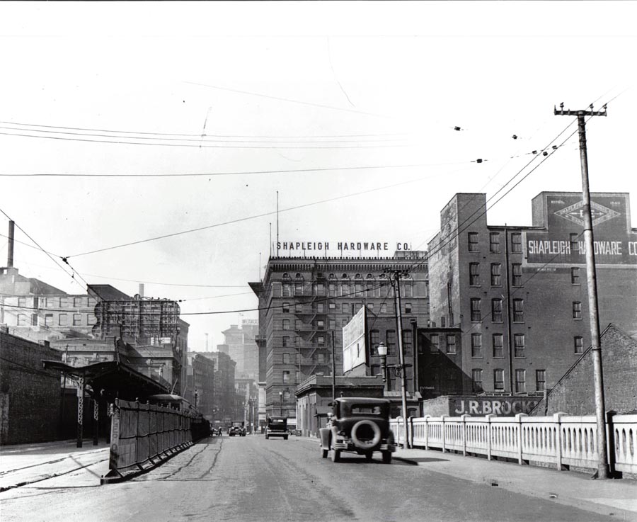
View west from the upper deck of the Eads Bridge, c. 1930. Photograph from the collection of Landmarks Association of St. Louis.
 Preservation Research Office
by Michael R. Allen
Consequently, Alderman Jeffrey Boyd (D-22), whose ward includes Wells-Goodfellow, and residents have been working to leverage federal block grant funds to pursue historic district designation for buildings and sections of the ward. These designations create incentives for rehabilitation and investment. Sure, it is a long road, but the neighborhood has been down a longer road of decline. Things aren’t going to change overnight, but things won’t change at all without laying groundwork for reinvestment.
From State Senator Jeff Smith:
Closer to home, I’m organizing our second annual Martin Luther King, Jr., Day Cleanup of MLK Jr. Blvd in the city, on Monday, Jan. 19 – the state holiday honoring the civil rights leader. This is a great opportunity to honor the life and memory of Dr. King, and last year, (in spite of the weather), we had a great time doing it. I invite any of you, along with your friends, friends, neighbors and any organizations to which you belong, to meet at the corner of MLK Jr. Boulevard and Union at 12 p.m. on Monday. Gloves, trash bags, donuts, and hot chocolate will be provided!
If you can make it, just call my district aide Johnny Little at (314) 601-4252, or reply to this email (jeff.smith.reply@gmail.com).
by Michael R. Allen
At last night’s candidate forum sponsored by the 15th Ward Democrats, Comptroller Darlene Green received applause for an issue not directly related to her campaign. When asked about red light cameras, she said that she definitely knew of a camera that needs to be removed: the red light camera at Grand and Chouteau. Mayor Francis Slay arrived during this time, so Green directly addressed the mayor from the podium.
The problem with the light, Green said, is that it is part of changes to the intersection that forces the three lanes of southbound traffic on Grand into two with a left-turn-only lane at Chouteau. Past Chouteau, the road is back to three lanes. Rarely do left turns clog the southbound lanes, and there are always vehicles in the inside lane that have to move over at the last minute to avoid getting a camera ticket from running straight in a turn-only lane.
The audience burst into applause, for good reason. That intersection reconfiguring is one of the silliest in the city. Before the camera went up, I joined many drivers in ignoring the changes. Since I am not an alderman, getting a red light ticket fixed might be difficult, so I now reluctantly obey the pointless changes there.
All of the red light cameras violate the spirit of the Fourth Amendment to the U.S. Constitution and any sensible view of law enforcement. I hope that Comptroller Green’s recommendation is followed, but we need to pull them out completely. The changes at Grand and Chouteau are blatantly revenue-driven, and impede smart traffic flow there. They need to be undone. Then we need to get rid of the remaining red light cameras and find a more dignified, constitutional way of enhancing city revenue.
A Flickr photographer has posted despressing photographs from the interior of the Fourth Baptist Church at 13th and Sullivan in Old North St. Louis. The worst part of these photographs is how much combustible material is evident.
Readers may recall that the church was struck by a huge fire on September 20, 2008. The fire severely damaged the sanctuary, while firefighters’ hose spray caused structural damage to an adjacent house and an attached annex. To date, a fence has been erected on the sidewalks around the wrecked church, but the windows are not yet boarded and evidently the interior is accessible. The small congregation has promised that stabilization work will begin in the spring, and assistance from the St. Louis Baptist community is on the way. Hopefully this promise holds true, because the Fourth Baptist Church, founded in 1851, is one of the region’s oldest congregations and deserves wide support in a heroic effort to save the church building.
The photographer concludes that “even after such a gigantic disaster, one can still see how reposed and fine it once was.” I concur, although I hold little hope that the entire complex will be rescued from tremendous damage. The sanctuary is vital, however, because it anchors not only the corner but site lines from the south on 13th Street and east on Sullivan Avenue. One can see the church from as far south as Warren Street, and from the east at Ames School. To have that view opened would be a tremendous loss to Old North.
by Michael R. Allen
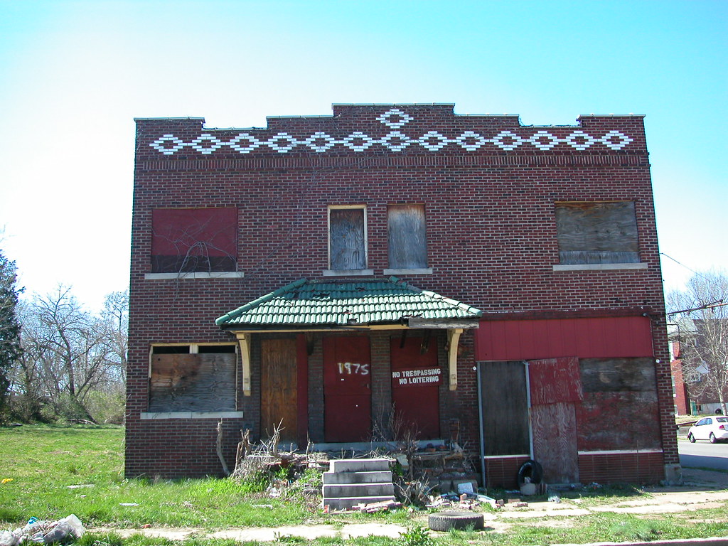
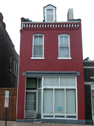
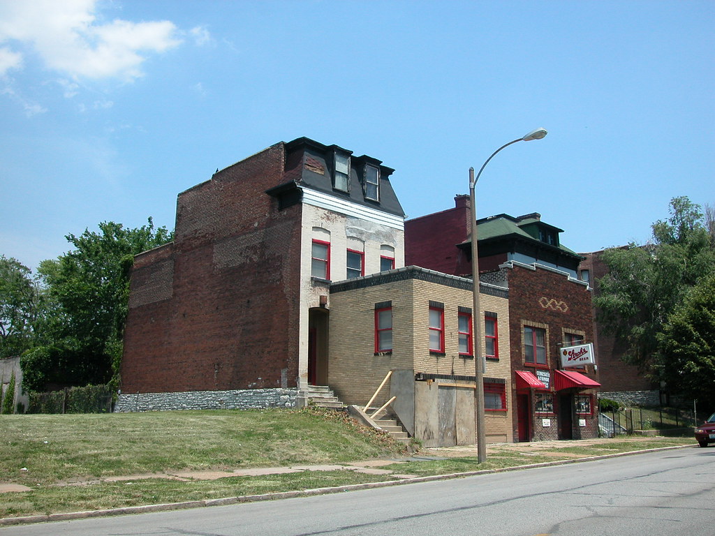
All across the city are examples of residential buildings adapted to later commercial use. As neighborhoods changed, so did uses. In early 19th century walking neighborhoods, commercial uses needed to be abundant to serve residents who could not travel far to get food, shoes or a hair cut. Later, after the streetcars gave middle- and working-class residents greater mobility, residential buildings located along street car lines were ripe for commercial use, especially in areas where property values declined because of the new street car lines.
Many examples of the common storefront addition involve the construction of connected one- or two-story buildings in the lawn space of houses and flats. However, in neighborhoods east of Grand, many early converted buildings stood at the sidewalk line. Here, the best way to create commercial space was through the insertion of storefront openings in existing front elevations. Typically, cast iron columns and combined beams would “jack” the new opening in the brick wall. Often, floor levels inside of the building would be altered to draw the shop floor down to sidewalk level from is common position at the head of foundation walls.
Two examples of similar buildings from different neighborhoods illustrate how this practice happened across the city.

by Michael R. Allen
My recent post on the demolished Delmar Foods storefront addition reminded me of the trove of storefront additions on Delmar Boulevard between Vandeventer and Whittier streets. Some were lost before my time, for sure, but the remaining examples are impressive.
Of course, I cannot attest to whether or not the storefront addition and house across the street from Delmar Foods was impressive. On June 10, 2006, I photographed the storefront addition at 4162 Delmar in the midst of demolition:
The remaining gems are one block east, all on the north side of the block. Two fancy additions stand adjacent to each other at 4033 (right) and 4035 (left) Delmar.
 The vacant storefront at 4035 Delmar dates to the early 1930s, and its parent house is a Second Empire town house from 1884. The storefront at 4033 Delmar houses Tennessee’s Lounge, and is less obviously an addition. The original house also dated to around 1884, and the addition to 1925. However, this was not the usual attachment, because the developer severely altered the house, removing its original roof line and building the addition into the house to completely
obscure it. According to records, the house at 4033 Delmar was the home of Gus C. Meissonier, a member of the Merchant’s Exchange. The conversion of the house of a member of the civic elite into commercial space was quite a big change.
A similar storefront addition project happened at 3963 Delmar eastward on the block, and coincidentally the space is also occupied by a lounge, Waldorf’s.
 These additions tell us about the rapid and abrupt changes of our city in the early days of the twentieth century. We were booming!
by Michael R. Allen
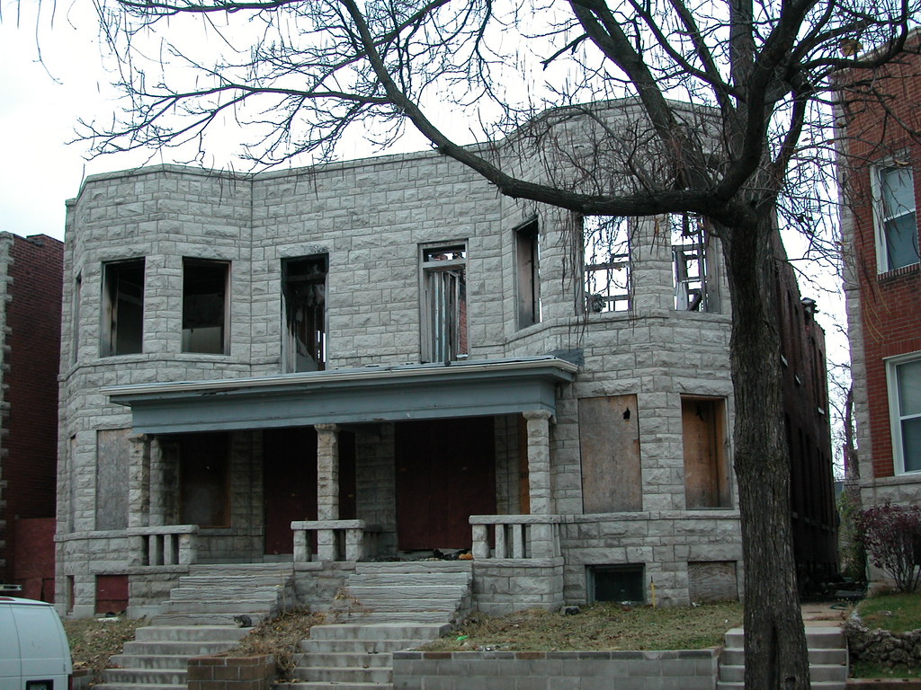 The 2007 fire that struck the four-flat at 3927-29 Shenandoah Avenue in the Shaw neighborhood eventually proved fatal. The building had been under rehabilitation when fire struck. The owners stopped paying taxes and mortgage payments, and ownership somehow split between Heartland Bank and the Land Reutilization Authority (the building straddles a lot line).
Obviously, the building was struck severely by the fire. Like most house fires, the fire spread upward and consumed the roof and second floor worst. Most of the roof sheathing was lost in the fire, leaving the building open to the elements. However, the walls had been tuckpointed and remained solid until the last days.
In October 2008, the Building Division condemned the building for demolition and sought demolition. Neighbors had filed many complaints on the condition of the house. Immediately to the west, a developer is rehabbing a similar building using historic rehab tax credits and understandably did not want a big question-mark next door.
After first being placed on the November 2008 agenda of the Preservation Board, the demolition shifted into high gear. Suddenly, the Building Division issued an emergency demolition order and paid to wreck the building. By the middle of December, it was gone. (Wonder if owner Heartland Bank got a bill for half of the cost?)
While the condition of the building was extreme, it was far from being a total loss. With solid masonry, the building was in no danger of immediate collapse. This could have been a great reconstruction project. Instead, the house went through the motions of our failed public safety laws: damage and abandonment, citizen complaints, emergency tear-down order. As the developers next door show, there is more than one way to fix a broken building, but the Building Division never seems to grasp that fact. Nor does the Cultural Resources Office (CRO) possess sufficient legal authority to prevent a senseless demolition like this one; the office and the Preservation Board were at the mercy of the Building Division, which controls what matters reach consideration of our preservation agency and its citizen commission. The CRO cannot override an emergency order, no matter how silly it is (and many are).
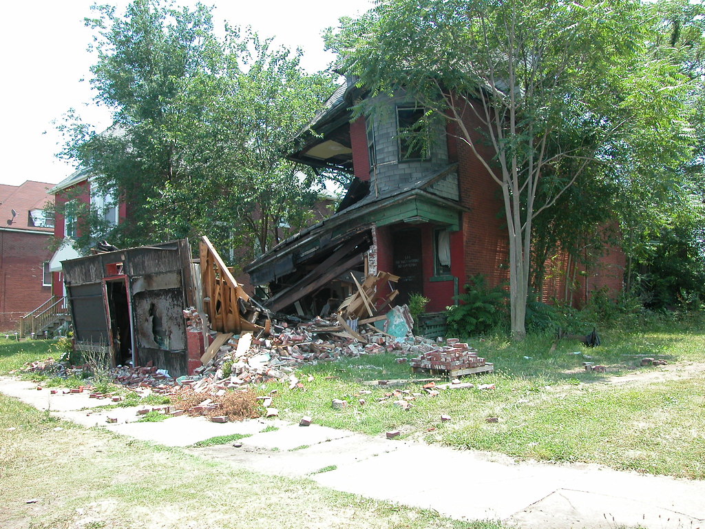
The neighbors’ momentary complaints are addressed, but they ultimately lose a remarkable street scape. On a block with only two gaps in continuous historic building line, both across the street, this demolition stands out. The demolition stands out even more since the demolished house is one of a row of five near-copies of the same plan built in 1903. defined by rusticated limestone front elevations, central porches and projecting bays on each end, the row was a handsome group.
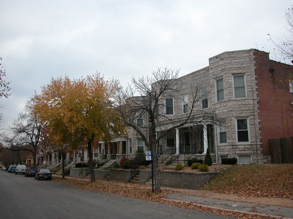
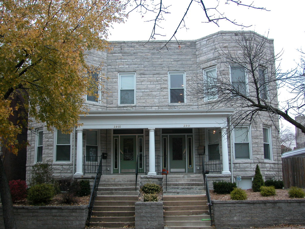
Looking at one of the extant members of this group, one sees the potential that the house at 3927-29 Shenandoah Avenue had, even in its fire-damaged state.
Demolition matters as much in a neighborhood as dense as Shaw as it does in a ravaged built environment like Old North. I would write that the only difference is why the buildings matter, but that would be false. The reason senseless demolitions harm our neighborhoods is because they erode the sense of place. Take away the last two buildings on a north side block, and the last vestige of the block’s urban character is gone forever. Take away one house on an intact block face in Shaw, and that block face is no longer intact. That brings a difference as big as taking down the last building standing. Besides, it’s not just a matter of blocks or neighborhoods but ultimately a matter of stewardship of this interconnected mass of resources we call St. Louis.
by Michael R. Allen
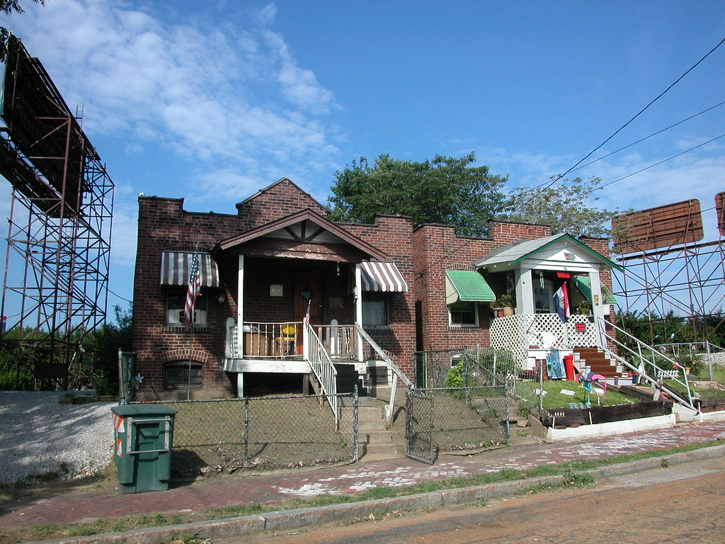 Eleventh Street continues north of Branch Street for two blocks, abruptly dead-ending where it meets the embankment of I-70. I-70 hems in the street and the pocket of residential Hyde Park that remains severed from the neighborhood. The city furthered this severance by officially drawing the Hyde Park boundary at I-70, which is certainly a barrier but nothing that defines any boundary of a neighborhood that has always started at the Mississippi River.
I love these two houses on the west side of Eleventh Street north of Branch. There are many small shaped-parapet bungalows in Hyde Park, built of pressed brick with wooden front porches. Houses like these line Agnes and Destrehan streets back in official Hyde Park. These homes date to the 1920s, when they went up en masse on undeveloped sites in the south end of the neighborhood. Few of those houses enjoy as dramatic a setting as these two now do. The highway in the back yard, giant billboards on each side — the only comfort found in one of these houses is its well-kept neighbor. The brick sidewalk in front adds another reminder of the lost connection with the historic world of Hyde Park.
On January 20th, the day Barack Obama will be inaugurated as President of the United States, area residents will have the opportunity to consider his predecessors at a talk in University City.
Esley Hamilton, Preservation Historian with the St. Louis County Department of Parks and Recreation, will present his talk Front Porch and Log Cabin: Presidential Homes and the Presidential Image at the Annual Meeting of the Sutter-Meyer Society. “The United States is unique among modern democracies in enshrining the homes of so many of its presidents,” says Hamilton. “These building have been used to shape the public’s perception of the president’s character both during and after the president’s lifetime.” The talk will explain how the homes are used and present a colorful tour of presidential sites all over the country.
The presentation on presidential homes will take place at the Annual Meeting of the Sutter-Meyer Society on Tuesday, January 20th at the Julia Goldstein Early Childhood Education Center at 737 Kingsland Avenue in University City. The short Annual Meeting will start at 6:30 p.m. The presentation on presidential homes will begin at
7:00 p.m.
The Sutter-Meyer Society (SMS) is a non-profit organization working to renovate the oldest building in University City to become a small community museum and educational facility, which will focus on the history of University City, St. Louis County and the greater St. Louis region.
The SMS “Radishes-to-Riches†Raffle will also take place at the Annual Meeting. Anyone interested in purchasing raffle ticket can send $20.00 per ticket to the Sutter-Meyer Society at 7141 Delmar Boulevard, St. Louis, Missouri 63130. The grand prize is $1,873, an amount that commemorates the year the Sutter-Meyer farmhouse was built.
FOR MORE INFORMATION: Shelley Welsch / 314-727-6852 / suttermeyersociety@ucitymo.com